Aztec Peak Topo Map Arizona
To zoom in, hover over the map of Aztec Peak
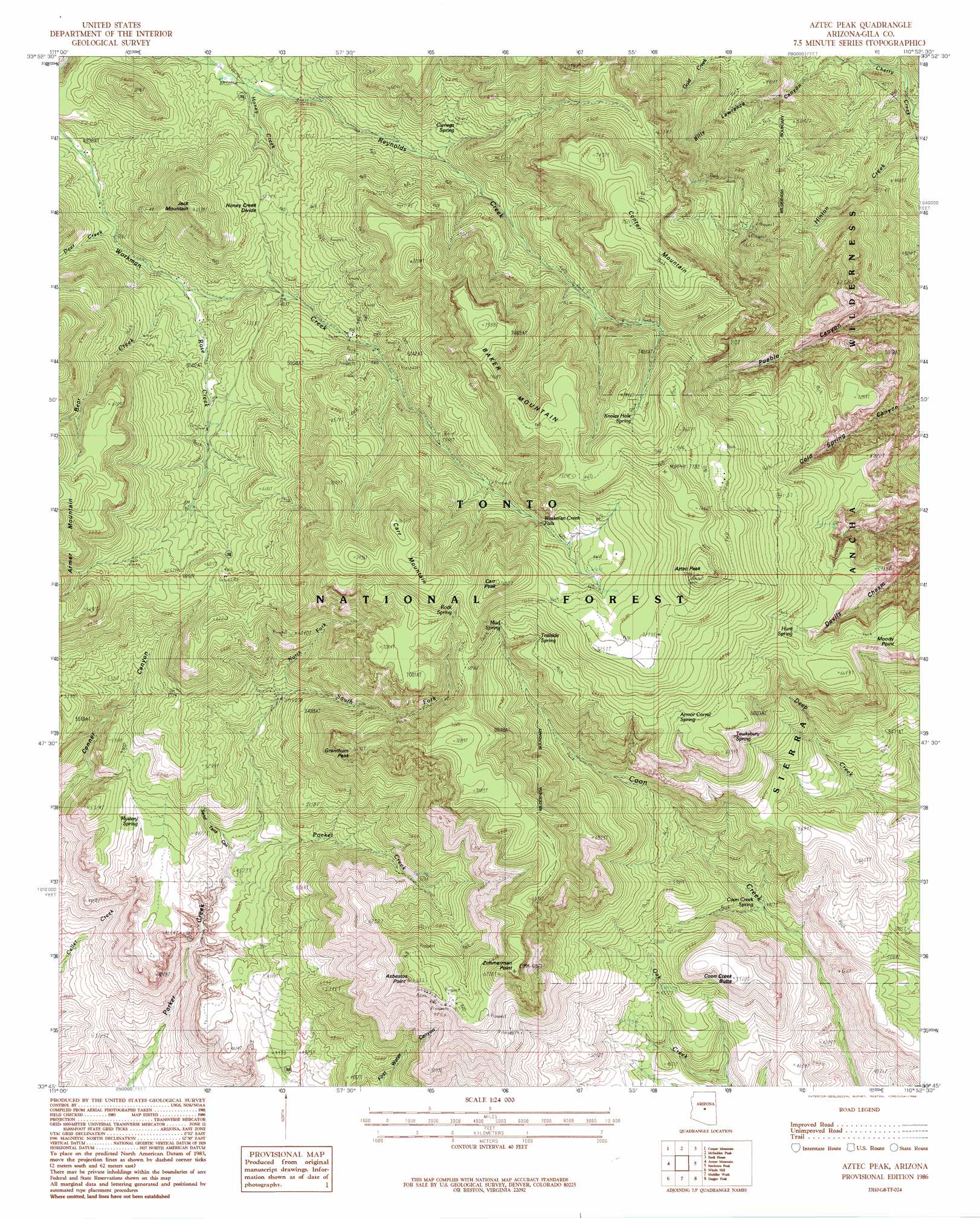
USGS Topo Quad 33110g8 - 1:24,000 scale
| Topo Map Name: | Aztec Peak |
| USGS Topo Quad ID: | 33110g8 |
| Print Size: | ca. 21 1/4" wide x 27" high |
| Southeast Coordinates: | 33.75° N latitude / 110.875° W longitude |
| Map Center Coordinates: | 33.8125° N latitude / 110.9375° W longitude |
| U.S. State: | AZ |
| Filename: | o33110g8.jpg |
| Download Map JPG Image: | Aztec Peak topo map 1:24,000 scale |
| Map Type: | Topographic |
| Topo Series: | 7.5´ |
| Map Scale: | 1:24,000 |
| Source of Map Images: | United States Geological Survey (USGS) |
| Alternate Map Versions: |
Aztec Peak AZ 1986, updated 1986 Download PDF Buy paper map Aztec Peak AZ 1986, updated 1986 Download PDF Buy paper map Aztec Peak AZ 2004, updated 2007 Download PDF Buy paper map Aztec Peak AZ 2011 Download PDF Buy paper map Aztec Peak AZ 2014 Download PDF Buy paper map |
| FStopo: | US Forest Service topo Aztec Peak is available: Download FStopo PDF Download FStopo TIF |
1:24,000 Topo Quads surrounding Aztec Peak
Sheep Basin Mountain |
Buzzard Roost Mesa |
Young |
Gentry Mountain |
Oak Creek Ranch |
Picture Mountain |
Copper Mountain |
Mcfadden Peak |
Rock House |
Double Buttes |
Greenback Creek |
Armer Mountain |
Aztec Peak |
Sombrero Peak |
Picacho Colorado |
Theodore Roosevelt Dam |
Windy Hill |
Meddler Wash |
Dagger Peak |
Haystack Butte |
Pinyon Mountain |
Two Bar Mountain |
Salt River Peak |
Rockinstraw Mountain |
Chrome Butte |
> Back to 33110e1 at 1:100,000 scale
> Back to 33110a1 at 1:250,000 scale
> Back to U.S. Topo Maps home
Aztec Peak topo map: Gazetteer
Aztec Peak: Falls
Workman Creek Falls elevation 2012m 6601′Aztec Peak: Forests
Sierra Ancha Experimental Forest elevation 1667m 5469′Aztec Peak: Mines
Lucky Strike Mine elevation 1802m 5912′Pueblo Mine elevation 1821m 5974′
Aztec Peak: Populated Places
Aztec Lodge elevation 1681m 5515′Rose Creek Lodge elevation 1641m 5383′
Aztec Peak: Reservoirs
Mesa Tank elevation 1537m 5042′Murphy Tank elevation 2173m 7129′
Never Go Dry Tank elevation 1580m 5183′
Ridge Tank elevation 1667m 5469′
Aztec Peak: Ridges
Honey Creek Divide elevation 1734m 5688′Aztec Peak: Springs
Armor Corral Spring elevation 2036m 6679′Cienega Spring elevation 1780m 5839′
Coon Creek Spring elevation 1370m 4494′
Edward Spring elevation 1914m 6279′
Hunt Spring elevation 1969m 6459′
Knoles Hole Spring elevation 2260m 7414′
Mud Spring elevation 2120m 6955′
Mystery Spring elevation 1475m 4839′
Rock Spring elevation 2102m 6896′
Rose Creek Spring elevation 1743m 5718′
Tewksbury Spring elevation 1890m 6200′
The Switchbacks Spring elevation 2024m 6640′
Trailside Spring elevation 2049m 6722′
Aztec Peak: Streams
Bear Creek elevation 1585m 5200′Deer Creek elevation 1553m 5095′
Honey Creek elevation 1589m 5213′
Horse Camp Creek elevation 1097m 3599′
McFadden Creek elevation 1595m 5232′
North Fork Parker Creek elevation 1556m 5104′
Pocket Creek elevation 1367m 4484′
Rose Creek elevation 1585m 5200′
South Fork Parker Creek elevation 1564m 5131′
Aztec Peak: Summits
Asbestos Point elevation 2021m 6630′Aztec Peak elevation 2342m 7683′
Baker Mountain elevation 2308m 7572′
Carr Mountain elevation 2328m 7637′
Carr Peak elevation 2320m 7611′
Center Mountain elevation 2274m 7460′
Coon Creek Butte elevation 1677m 5501′
Grantham Peak elevation 1954m 6410′
Jack Mountain elevation 1972m 6469′
Zimmerman Point elevation 2106m 6909′
Aztec Peak: Trails
Coon Spring Trail elevation 1487m 4878′Aztec Peak: Valleys
Sand Tank Canyon elevation 1356m 4448′Aztec Peak digital topo map on disk
Buy this Aztec Peak topo map showing relief, roads, GPS coordinates and other geographical features, as a high-resolution digital map file on DVD: