Mineral Mountain Topo Map Arizona
To zoom in, hover over the map of Mineral Mountain
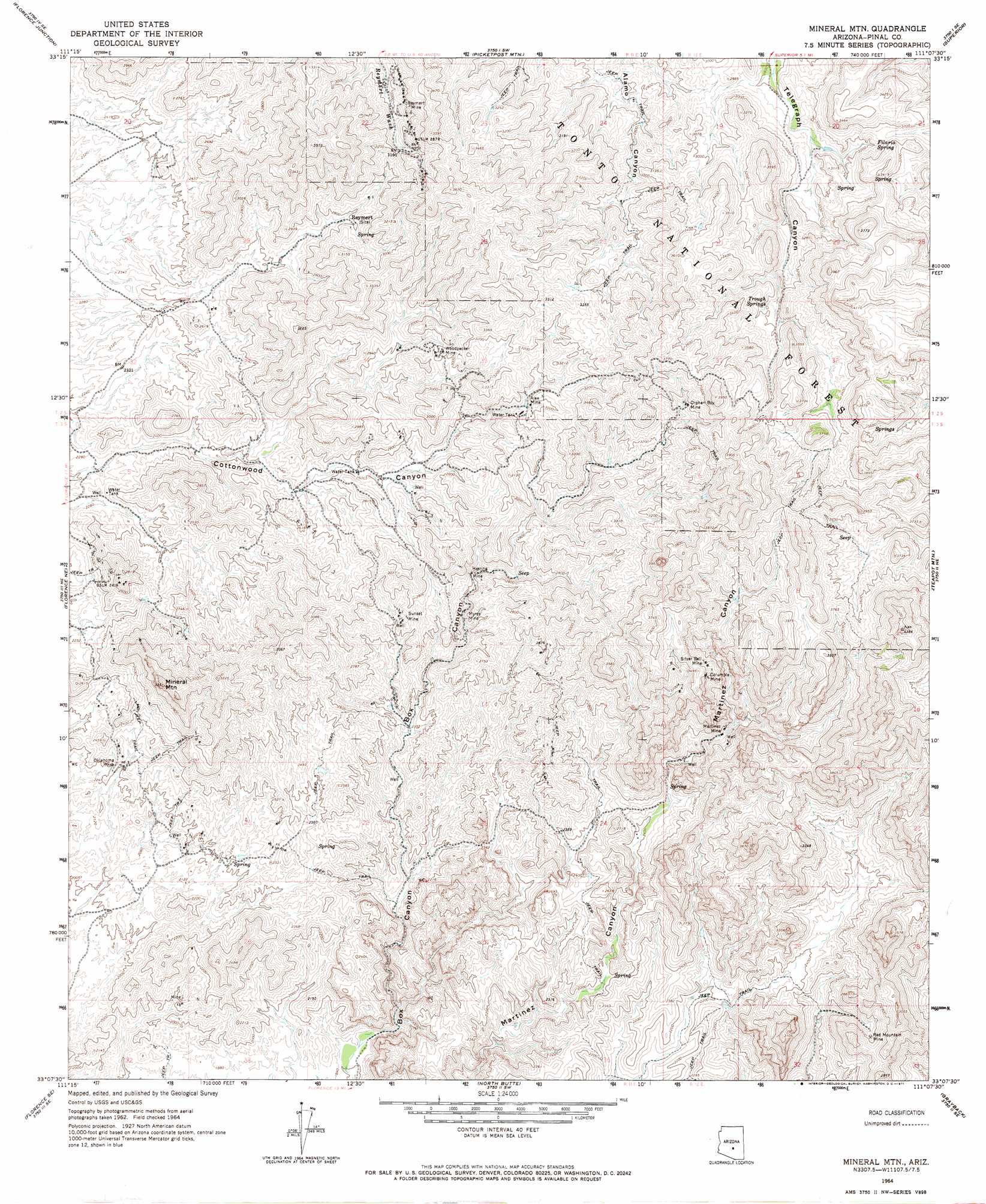
USGS Topo Quad 33111b2 - 1:24,000 scale
| Topo Map Name: | Mineral Mountain |
| USGS Topo Quad ID: | 33111b2 |
| Print Size: | ca. 21 1/4" wide x 27" high |
| Southeast Coordinates: | 33.125° N latitude / 111.125° W longitude |
| Map Center Coordinates: | 33.1875° N latitude / 111.1875° W longitude |
| U.S. State: | AZ |
| Filename: | o33111b2.jpg |
| Download Map JPG Image: | Mineral Mountain topo map 1:24,000 scale |
| Map Type: | Topographic |
| Topo Series: | 7.5´ |
| Map Scale: | 1:24,000 |
| Source of Map Images: | United States Geological Survey (USGS) |
| Alternate Map Versions: |
Mineral Mtn AZ 1964, updated 1965 Download PDF Buy paper map Mineral Mtn AZ 1964, updated 1971 Download PDF Buy paper map Mineral Mtn AZ 1964, updated 1971 Download PDF Buy paper map Mineral Mountain AZ 2004, updated 2007 Download PDF Buy paper map Mineral Mountain AZ 2011 Download PDF Buy paper map Mineral Mountain AZ 2014 Download PDF Buy paper map |
| FStopo: | US Forest Service topo Mineral Mountain is available: Download FStopo PDF Download FStopo TIF |
1:24,000 Topo Quads surrounding Mineral Mountain
Goldfield |
Weavers Needle |
Iron Mountain |
Haunted Canyon |
Inspiration |
Superstition Mountains Sw |
Florence Junction |
Picketpost Mountain |
Superior |
Pinal Ranch |
Magma |
Florence Ne |
Mineral Mountain |
Teapot Mountain |
Hot Tamale Peak |
Florence |
Florence Se |
North Butte |
Grayback |
Kearny |
Valley Farms |
Cactus Forest |
Ninetysix Hills Nw |
Ninetysix Hills Ne |
Crozier Peak |
> Back to 33111a1 at 1:100,000 scale
> Back to 33110a1 at 1:250,000 scale
> Back to U.S. Topo Maps home
Mineral Mountain topo map: Gazetteer
Mineral Mountain: Mines
Ajax Mine elevation 911m 2988′Columbia Mine elevation 982m 3221′
Herring Mine elevation 793m 2601′
Martinez Mine elevation 832m 2729′
Myres Mine elevation 779m 2555′
Oklahoma Mine elevation 682m 2237′
Orphan Boy Mine elevation 1027m 3369′
Red Mountain Mine elevation 771m 2529′
Reymert Mine elevation 968m 3175′
Silver Bell Mine elevation 1011m 3316′
Sunset Mine elevation 832m 2729′
Woodpecker Mine elevation 930m 3051′
Mineral Mountain: Populated Places
Reymert elevation 854m 2801′Mineral Mountain: Reservoirs
Alamo Number One Tank elevation 959m 3146′Alamo Number Two Tank elevation 893m 2929′
Mesa Tank elevation 1025m 3362′
Rock Tank elevation 887m 2910′
Talley Tank elevation 1078m 3536′
Mineral Mountain: Springs
Filaria Spring elevation 924m 3031′Seep Spring elevation 1061m 3480′
Trough Springs elevation 963m 3159′
Mineral Mountain: Summits
Bell Butte elevation 943m 3093′Mineral Mountain elevation 988m 3241′
Mineral Mountain: Wells
Martinez Well elevation 832m 2729′Picket Mill Well elevation 833m 2732′
Mineral Mountain digital topo map on disk
Buy this Mineral Mountain topo map showing relief, roads, GPS coordinates and other geographical features, as a high-resolution digital map file on DVD: