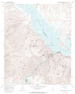
Theodore Roosevelt Dam Topo Map Arizona
To zoom in, hover over the map of Theodore Roosevelt Dam
USGS Topo Quad 33111f2 - 1:24,000 scale
| Topo Map Name: | Theodore Roosevelt Dam |
| USGS Topo Quad ID: | 33111f2 |
| Print Size: | ca. 21 1/4" wide x 27" high |
| Southeast Coordinates: | 33.625° N latitude / 111.125° W longitude |
| Map Center Coordinates: | 33.6875° N latitude / 111.1875° W longitude |
| U.S. State: | AZ |
| Filename: | o33111f2.jpg |
| Download Map JPG Image: | Theodore Roosevelt Dam topo map 1:24,000 scale |
| Map Type: | Topographic |
| Topo Series: | 7.5´ |
| Map Scale: | 1:24,000 |
| Source of Map Images: | United States Geological Survey (USGS) |
| Alternate Map Versions: |
Theodore Roosevelt Dam AZ 1964, updated 1965 Download PDF Buy paper map Theodore Roosevelt Dam AZ 1964, updated 1970 Download PDF Buy paper map Theodore Roosevelt Dam AZ 2004, updated 2007 Download PDF Buy paper map Theodore Roosevelt Dam AZ 2011 Download PDF Buy paper map Theodore Roosevelt Dam AZ 2014 Download PDF Buy paper map |
| FStopo: | US Forest Service topo Theodore Roosevelt Dam is available: Download FStopo PDF Download FStopo TIF |
1:24,000 Topo Quads surrounding Theodore Roosevelt Dam
> Back to 33111e1 at 1:100,000 scale
> Back to 33110a1 at 1:250,000 scale
> Back to U.S. Topo Maps home
Theodore Roosevelt Dam topo map: Gazetteer
Theodore Roosevelt Dam: Airports
Roosevelt Dam Heliport elevation 585m 1919′Theodore Roosevelt Dam: Basins
Buckhorn Basin elevation 843m 2765′Theodore Roosevelt Dam: Bays
Bachelor Cove Area elevation 639m 2096′Cholla Bay Area elevation 639m 2096′
Mills Cove elevation 639m 2096′
Mills Cove Area elevation 639m 2096′
Soltera Cove elevation 644m 2112′
Theodore Roosevelt Dam: Capes
Bass Point elevation 666m 2185′Hotel Point elevation 639m 2096′
Theodore Roosevelt Dam: Channels
Fools Pass elevation 648m 2125′Theodore Roosevelt Dam: Cliffs
Inspiration Point elevation 928m 3044′Theodore Roosevelt Dam: Dams
Theodore Roosevelt Dam elevation 639m 2096′Theodore Roosevelt Dam: Flats
Goose Flats elevation 651m 2135′Squaw Flat elevation 632m 2073′
Theodore Roosevelt Dam: Islands
Haystack Island elevation 659m 2162′Rabbit Island elevation 655m 2148′
Rock Island elevation 695m 2280′
Theodore Roosevelt Dam: Parks
Horse Pasture Recreation Area elevation 658m 2158′Roosevelt Lake Wildlife Area elevation 639m 2096′
Three Bar Wildlife Enclosure elevation 922m 3024′
Theodore Roosevelt Dam: Populated Places
Government Hill elevation 682m 2237′Lakeview Trailer Park elevation 690m 2263′
Roosevelt elevation 677m 2221′
Theodore Roosevelt Dam: Reservoirs
Buckhorn Tank elevation 1085m 3559′Coyote Tank elevation 1031m 3382′
Deer Hill Tank elevation 1068m 3503′
Lake Tank elevation 709m 2326′
Mills Ridge Tank elevation 892m 2926′
South Cactus Tank elevation 771m 2529′
Theodore Roosevelt Lake elevation 639m 2096′
Theodore Roosevelt Dam: Springs
Buckhorn Spring elevation 807m 2647′Canyon Spring elevation 864m 2834′
Hackberry Spring elevation 708m 2322′
Hillside Spring elevation 1002m 3287′
Long Gulch Spring elevation 695m 2280′
Thompson Spring elevation 720m 2362′
Tuakay Hot Springs elevation 677m 2221′
Vineyard Spring elevation 852m 2795′
Wildcat Seep elevation 867m 2844′
Theodore Roosevelt Dam: Streams
Buckhorn Creek elevation 584m 1916′Cottonwood Creek elevation 654m 2145′
Fox Gulch Sycamore Creek elevation 652m 2139′
Hackberry Creek elevation 656m 2152′
Methodist Creek elevation 640m 2099′
Rock Creek elevation 649m 2129′
Tonto Creek elevation 639m 2096′
Theodore Roosevelt Dam: Summits
Deer Hill elevation 1153m 3782′Henderson Mesa elevation 733m 2404′
Peters Mountain elevation 1005m 3297′
Pico Derecho Mountain elevation 685m 2247′
Sweetheart Peak elevation 771m 2529′
Vineyard Mountain elevation 1052m 3451′
Theodore Roosevelt Dam: Trails
Granite Spring Trail elevation 1135m 3723′Theodore Roosevelt Dam: Valleys
Alchesay Canyon elevation 596m 1955′Chuckwalla Canyon elevation 692m 2270′
Little Salt River Valley (historical) elevation 639m 2096′
Long Gulch elevation 639m 2096′
Mills Canyon elevation 639m 2096′
Vineyard Canyon elevation 639m 2096′
Theodore Roosevelt Dam digital topo map on disk
Buy this Theodore Roosevelt Dam topo map showing relief, roads, GPS coordinates and other geographical features, as a high-resolution digital map file on DVD:


