Mine Mountain Topo Map Arizona
To zoom in, hover over the map of Mine Mountain
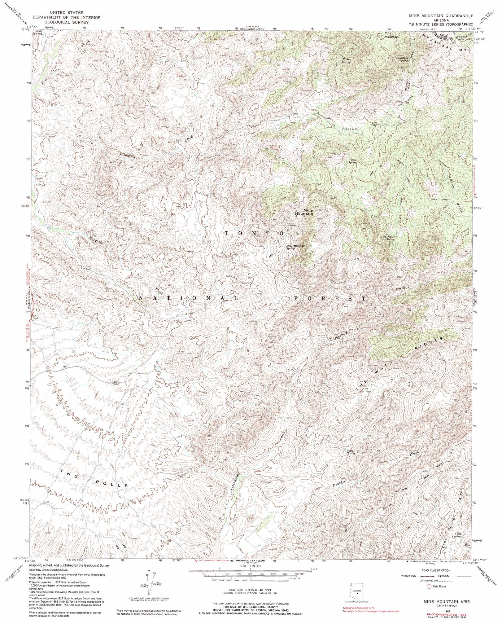
USGS Topo Quad 33111f4 - 1:24,000 scale
| Topo Map Name: | Mine Mountain |
| USGS Topo Quad ID: | 33111f4 |
| Print Size: | ca. 21 1/4" wide x 27" high |
| Southeast Coordinates: | 33.625° N latitude / 111.375° W longitude |
| Map Center Coordinates: | 33.6875° N latitude / 111.4375° W longitude |
| U.S. State: | AZ |
| Filename: | o33111f4.jpg |
| Download Map JPG Image: | Mine Mountain topo map 1:24,000 scale |
| Map Type: | Topographic |
| Topo Series: | 7.5´ |
| Map Scale: | 1:24,000 |
| Source of Map Images: | United States Geological Survey (USGS) |
| Alternate Map Versions: |
Mine Mountain AZ 1963, updated 1965 Download PDF Buy paper map Mine Mountain AZ 1963, updated 1972 Download PDF Buy paper map Mine Mountain AZ 1963, updated 1985 Download PDF Buy paper map Mine Mountain AZ 1963, updated 1992 Download PDF Buy paper map Mine Mountain AZ 2004, updated 2007 Download PDF Buy paper map Mine Mountain AZ 2011 Download PDF Buy paper map Mine Mountain AZ 2014 Download PDF Buy paper map |
| FStopo: | US Forest Service topo Mine Mountain is available: Download FStopo PDF Download FStopo TIF |
1:24,000 Topo Quads surrounding Mine Mountain
Horseshoe Dam |
Lion Mountain |
Reno Pass |
Kayler Butte |
Picture Mountain |
Bartlett Dam |
Maverick Mountain |
Boulder Mountain |
Tonto Basin |
Greenback Creek |
Fort Mcdowell |
Adams Mesa |
Mine Mountain |
Four Peaks |
Theodore Roosevelt Dam |
Granite Reef Dam |
Stewart Mountain |
Mormon Flat Dam |
Horse Mesa Dam |
Pinyon Mountain |
Buckhorn |
Apache Junction |
Goldfield |
Weavers Needle |
Iron Mountain |
> Back to 33111e1 at 1:100,000 scale
> Back to 33110a1 at 1:250,000 scale
> Back to U.S. Topo Maps home
Mine Mountain topo map: Gazetteer
Mine Mountain: Areas
The Rolls elevation 707m 2319′Mine Mountain: Cliffs
Malpais Cliffs elevation 1464m 4803′Mine Mountain: Ridges
The Wata Ridges elevation 1359m 4458′Mine Mountain: Springs
Cane Spring elevation 878m 2880′Cold Water Spring elevation 1182m 3877′
Coyote Spring elevation 1728m 5669′
Fisher Spring elevation 1456m 4776′
Mine Mountain Spring elevation 1128m 3700′
Mountain Spring elevation 1647m 5403′
Mud Springs elevation 660m 2165′
Wata Spring elevation 777m 2549′
Willow Spring elevation 1302m 4271′
Mine Mountain: Streams
Boulder Creek elevation 581m 1906′Mine Mountain: Summits
Bullfrog (historical) elevation 811m 2660′Mine Mountain elevation 1575m 5167′
Pine Mountain elevation 1896m 6220′
Mine Mountain digital topo map on disk
Buy this Mine Mountain topo map showing relief, roads, GPS coordinates and other geographical features, as a high-resolution digital map file on DVD: