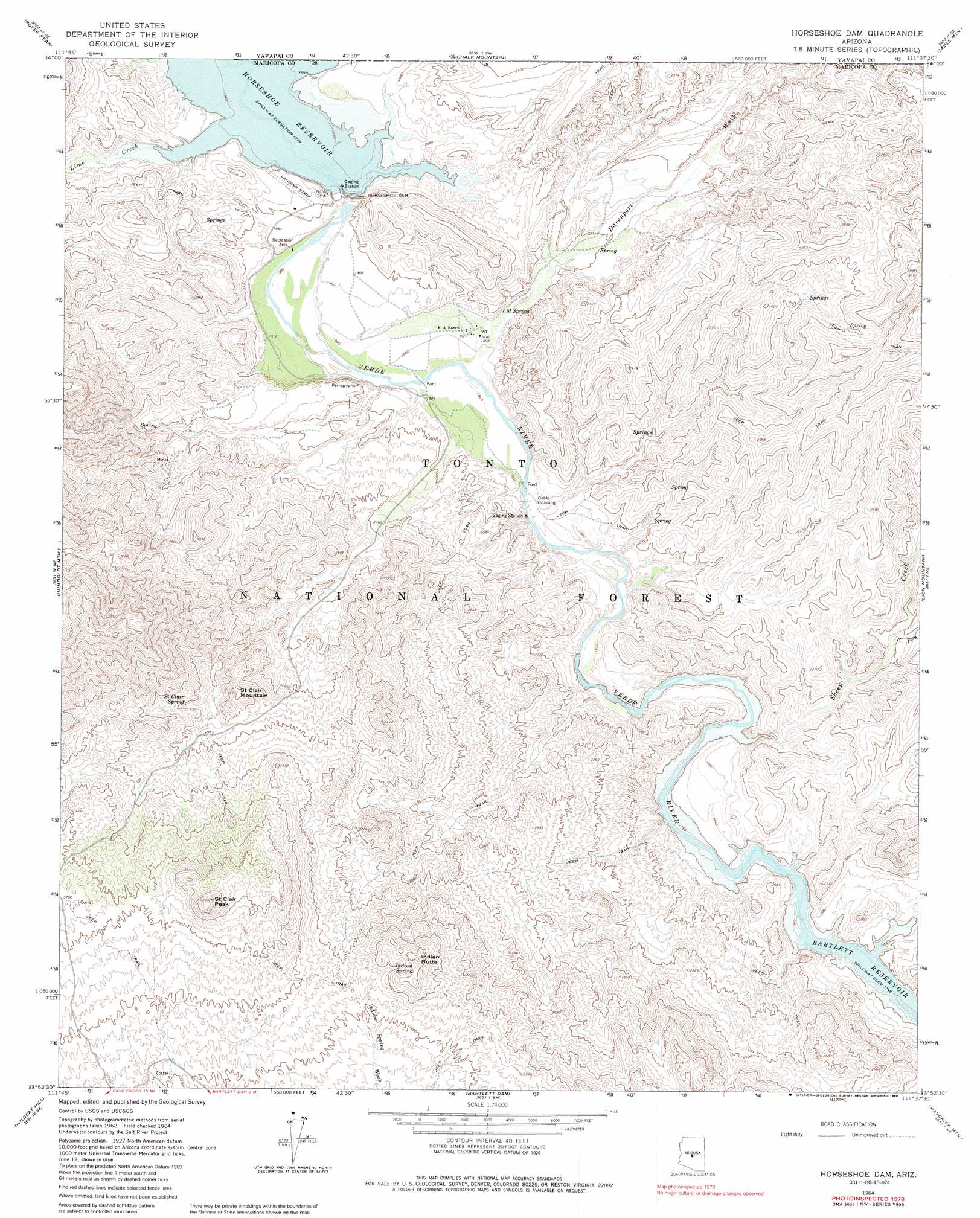
Horseshoe Dam Topo Map Arizona
To zoom in, hover over the map of Horseshoe Dam
USGS Topo Quad 33111h6 - 1:24,000 scale
| Topo Map Name: | Horseshoe Dam |
| USGS Topo Quad ID: | 33111h6 |
| Print Size: | ca. 21 1/4" wide x 27" high |
| Southeast Coordinates: | 33.875° N latitude / 111.625° W longitude |
| Map Center Coordinates: | 33.9375° N latitude / 111.6875° W longitude |
| U.S. State: | AZ |
| Filename: | o33111h6.jpg |
| Download Map JPG Image: | Horseshoe Dam topo map 1:24,000 scale |
| Map Type: | Topographic |
| Topo Series: | 7.5´ |
| Map Scale: | 1:24,000 |
| Source of Map Images: | United States Geological Survey (USGS) |
| Alternate Map Versions: |
Horseshoe Dam AZ 1964, updated 1965 Download PDF Buy paper map Horseshoe Dam AZ 1964, updated 1970 Download PDF Buy paper map Horseshoe Dam AZ 1964, updated 1986 Download PDF Buy paper map Horseshoe Dam AZ 2004, updated 2006 Download PDF Buy paper map Horseshoe Dam AZ 2011 Download PDF Buy paper map Horseshoe Dam AZ 2014 Download PDF Buy paper map |
| FStopo: | US Forest Service topo Horseshoe Dam is available: Download FStopo PDF Download FStopo TIF |
1:24,000 Topo Quads surrounding Horseshoe Dam
Brooklyn Peak |
Bloody Basin |
Wet Bottom Mesa |
Cypress Butte |
North Peak |
Cooks Mesa |
Rover Peak |
Chalk Mountain |
Table Mountain |
Mazatzal Peak |
New River Mesa |
Humboldt Mountain |
Horseshoe Dam |
Lion Mountain |
Reno Pass |
Cave Creek |
Wildcat Hill |
Bartlett Dam |
Maverick Mountain |
Boulder Mountain |
Currys Corner |
Mcdowell Peak |
Fort Mcdowell |
Adams Mesa |
Mine Mountain |
> Back to 33111e1 at 1:100,000 scale
> Back to 33110a1 at 1:250,000 scale
> Back to U.S. Topo Maps home
Horseshoe Dam topo map: Gazetteer
Horseshoe Dam: Airports
Horseshoe Dam Heliport elevation 618m 2027′Horseshoe Dam: Bays
Devils Hole elevation 548m 1797′Echo Bay elevation 533m 1748′
Jacks Cove elevation 534m 1751′
Horseshoe Dam: Dams
Horseshoe Dam elevation 610m 2001′Horseshoe Dam: Parks
Fishermans Point Recreation Area elevation 583m 1912′Gilbert Park elevation 1023m 3356′
Horseshoe Recreation Area elevation 585m 1919′
Mesquite Recreation Area elevation 580m 1902′
Horseshoe Dam: Reservoirs
Chalk Tank elevation 765m 2509′Horseshoe Reservoir elevation 610m 2001′
Horseshoe Dam: Springs
Basin Spring elevation 776m 2545′Chalk Spring elevation 622m 2040′
Cholla Spring elevation 783m 2568′
Fig Spring elevation 608m 1994′
Indian Spring elevation 1032m 3385′
J M Spring elevation 595m 1952′
Saint Clair Spring elevation 900m 2952′
Trail Springs elevation 761m 2496′
Willow Spring elevation 659m 2162′
Horseshoe Dam: Streams
Davenport Wash elevation 564m 1850′Lime Creek elevation 610m 2001′
Sheep Creek elevation 545m 1788′
South Fork Sheep Creek elevation 601m 1971′
Horseshoe Dam: Summits
Indian Butte elevation 1133m 3717′Mesquite Flat elevation 621m 2037′
Saint Clair Mountain elevation 981m 3218′
Saint Clair Peak elevation 1284m 4212′
Horseshoe Dam digital topo map on disk
Buy this Horseshoe Dam topo map showing relief, roads, GPS coordinates and other geographical features, as a high-resolution digital map file on DVD: