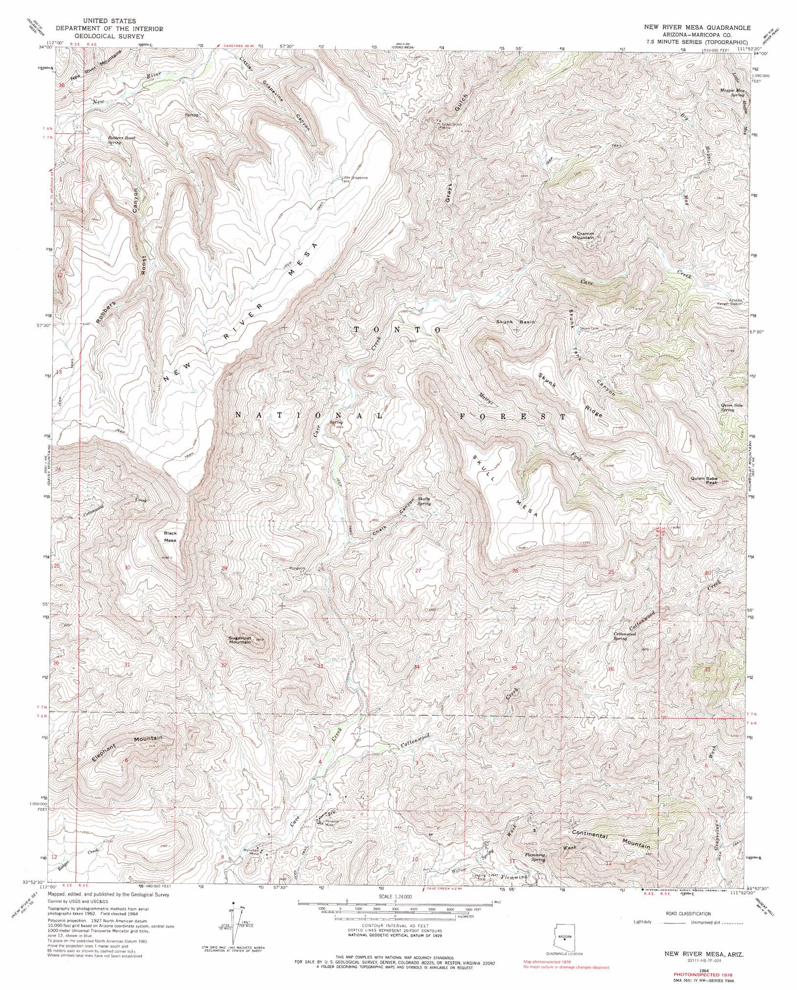
New River Mesa Topo Map Arizona
To zoom in, hover over the map of New River Mesa
USGS Topo Quad 33111h8 - 1:24,000 scale
| Topo Map Name: | New River Mesa |
| USGS Topo Quad ID: | 33111h8 |
| Print Size: | ca. 21 1/4" wide x 27" high |
| Southeast Coordinates: | 33.875° N latitude / 111.875° W longitude |
| Map Center Coordinates: | 33.9375° N latitude / 111.9375° W longitude |
| U.S. State: | AZ |
| Filename: | o33111h8.jpg |
| Download Map JPG Image: | New River Mesa topo map 1:24,000 scale |
| Map Type: | Topographic |
| Topo Series: | 7.5´ |
| Map Scale: | 1:24,000 |
| Source of Map Images: | United States Geological Survey (USGS) |
| Alternate Map Versions: |
New River Mesa AZ 1964, updated 1965 Download PDF Buy paper map New River Mesa AZ 1964, updated 1971 Download PDF Buy paper map New River Mesa AZ 1964, updated 1987 Download PDF Buy paper map New River Mesa AZ 1964, updated 1987 Download PDF Buy paper map New River Mesa AZ 2004, updated 2006 Download PDF Buy paper map New River Mesa AZ 2011 Download PDF Buy paper map New River Mesa AZ 2014 Download PDF Buy paper map |
| FStopo: | US Forest Service topo New River Mesa is available: Download FStopo PDF Download FStopo TIF |
1:24,000 Topo Quads surrounding New River Mesa
Bumble Bee |
Joes Hill |
Brooklyn Peak |
Bloody Basin |
Wet Bottom Mesa |
Black Canyon City |
Squaw Creek Mesa |
Cooks Mesa |
Rover Peak |
Chalk Mountain |
New River |
Daisy Mountain |
New River Mesa |
Humboldt Mountain |
Horseshoe Dam |
Biscuit Flat |
New River Se |
Cave Creek |
Wildcat Hill |
Bartlett Dam |
Hedgpeth Hills |
Union Hills |
Currys Corner |
Mcdowell Peak |
Fort Mcdowell |
> Back to 33111e1 at 1:100,000 scale
> Back to 33110a1 at 1:250,000 scale
> Back to U.S. Topo Maps home
New River Mesa topo map: Gazetteer
New River Mesa: Basins
Skunk Basin elevation 956m 3136′New River Mesa: Mines
Grays Gulch Mine elevation 1058m 3471′Maricopa Mine elevation 723m 2372′
Phoenix Mine elevation 752m 2467′
Quien Sabe Mine elevation 1238m 4061′
New River Mesa: Parks
Spur Cross Ranch Conservation Area elevation 758m 2486′New River Mesa: Reservoirs
Big Tank elevation 1379m 4524′Division Tank elevation 1350m 4429′
Little Grapevine Tank elevation 1267m 4156′
Lopez Tank elevation 1070m 3510′
Mesa Tank elevation 1279m 4196′
Middle Tank elevation 1263m 4143′
New River Mesa Tank elevation 1296m 4251′
Reed Tank elevation 1257m 4124′
Road Tank elevation 1268m 4160′
Ruin Tank elevation 1134m 3720′
Skunk Tank elevation 1107m 3631′
New River Mesa: Ridges
Skunk Ridge elevation 1263m 4143′New River Mesa: Springs
Board Spring elevation 958m 3143′Burro Spring elevation 1065m 3494′
Cement Spring elevation 842m 2762′
Chalk Spring elevation 917m 3008′
Cottonwood Spring elevation 889m 2916′
Cottonwood Spring elevation 962m 3156′
Flemming Spring elevation 908m 2979′
Lewis Spring elevation 1124m 3687′
Little Wonder Spring elevation 766m 2513′
Maggie May Spring elevation 1158m 3799′
Quien Sabe Spring elevation 1193m 3914′
Robbers Roost Spring elevation 956m 3136′
Rock Tank Spring elevation 862m 2828′
Shulte Spring elevation 898m 2946′
New River Mesa: Streams
Big Maggie May elevation 983m 3225′Cottonwood Creek elevation 707m 2319′
Flemming Wash elevation 780m 2559′
Mattys Fork elevation 852m 2795′
Quien Sabe Creek elevation 991m 3251′
New River Mesa: Summits
Black Mesa elevation 1430m 4691′Continental Mountain elevation 1356m 4448′
Cramm Mountain elevation 1195m 3920′
Elephant Mountain elevation 1192m 3910′
New River Mesa elevation 1426m 4678′
Quien Sabe Peak elevation 1486m 4875′
Skull Mesa elevation 1347m 4419′
Sugarloaf Mountain elevation 1177m 3861′
New River Mesa: Valleys
Chalk Canyon elevation 768m 2519′Grays Gulch elevation 882m 2893′
Little Grapevine Canyon elevation 944m 3097′
Robbers Roost Canyon elevation 902m 2959′
Skunk Tank Canyon elevation 906m 2972′
New River Mesa digital topo map on disk
Buy this New River Mesa topo map showing relief, roads, GPS coordinates and other geographical features, as a high-resolution digital map file on DVD: