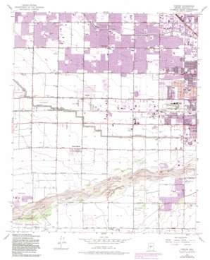
Fowler Topo Map Arizona
To zoom in, hover over the map of Fowler
USGS Topo Quad 33112d2 - 1:24,000 scale
| Topo Map Name: | Fowler |
| USGS Topo Quad ID: | 33112d2 |
| Print Size: | ca. 21 1/4" wide x 27" high |
| Southeast Coordinates: | 33.375° N latitude / 112.125° W longitude |
| Map Center Coordinates: | 33.4375° N latitude / 112.1875° W longitude |
| U.S. State: | AZ |
| Filename: | o33112d2.jpg |
| Download Map JPG Image: | Fowler topo map 1:24,000 scale |
| Map Type: | Topographic |
| Topo Series: | 7.5´ |
| Map Scale: | 1:24,000 |
| Source of Map Images: | United States Geological Survey (USGS) |
| Alternate Map Versions: |
Fowler AZ 1952, updated 1957 Download PDF Buy paper map Fowler AZ 1952, updated 1967 Download PDF Buy paper map Fowler AZ 1952, updated 1968 Download PDF Buy paper map Fowler AZ 1952, updated 1975 Download PDF Buy paper map Fowler AZ 1952, updated 1983 Download PDF Buy paper map Fowler AZ 1952, updated 1983 Download PDF Buy paper map Fowler AZ 1971, updated 1972 Download PDF Buy paper map Fowler AZ 2011 Download PDF Buy paper map Fowler AZ 2014 Download PDF Buy paper map |
1:24,000 Topo Quads surrounding Fowler
> Back to 33112a1 at 1:100,000 scale
> Back to 33112a1 at 1:250,000 scale
> Back to U.S. Topo Maps home
Fowler topo map: Gazetteer
Fowler: Airports
Farm Aero Airport elevation 314m 1030′Gila Port Airport elevation 309m 1013′
Paradise Air Park elevation 309m 1013′
Phoenix Area Heliport elevation 321m 1053′
Phoenix District Airport elevation 321m 1053′
S R P Tolleson Center Heliport elevation 315m 1033′
Westridge Mall Heliport elevation 323m 1059′
Fowler: Canals
Canal Alamo (historical) elevation 313m 1026′Canal Baseline (historical) elevation 300m 984′
Canal Five (historical) elevation 323m 1059′
Canal Laveen (historical) elevation 315m 1033′
Canal Laveen South Branch (historical) elevation 315m 1033′
Canal Rio Lower Branch (historical) elevation 313m 1026′
Canal Six (historical) elevation 318m 1043′
Canal Three (historical) elevation 310m 1017′
Fowler: Crossings
Interchange 135 elevation 316m 1036′Interchange 136A elevation 318m 1043′
Interchange 136B elevation 308m 1010′
Interchange 137 elevation 321m 1053′
Interchange 138 elevation 324m 1062′
Interchange 139 elevation 326m 1069′
Interchange 140 elevation 326m 1069′
Interchange 141 elevation 327m 1072′
Fowler: Parks
Alegre Park elevation 326m 1069′Alvord Park elevation 324m 1062′
Eloso Park elevation 328m 1076′
Falcon Park elevation 326m 1069′
Manzanita Park elevation 315m 1033′
Marivue Park elevation 333m 1092′
Maryvale Play Lot elevation 330m 1082′
Orme Park elevation 335m 1099′
Playa Margarita Park elevation 315m 1033′
Smith Park elevation 322m 1056′
Starlight Park elevation 327m 1072′
Sueno Park elevation 330m 1082′
Fowler: Populated Places
Alhambra elevation 342m 1122′Blue Bell Mobile Home Park elevation 323m 1059′
Capri Village elevation 324m 1062′
Cartwright elevation 330m 1082′
Catalina Village elevation 326m 1069′
Centura West elevation 323m 1059′
County Fair West elevation 328m 1076′
Desert Gem Mobile Home Park elevation 319m 1046′
Fowler elevation 318m 1043′
Hidden Acres Mobile Home Park elevation 319m 1046′
La Terraza elevation 324m 1062′
Lazy Daze Mobile Home Park elevation 323m 1059′
Legend Estates elevation 328m 1076′
Maryvale Terrace elevation 335m 1099′
Michigan Trailer Park elevation 339m 1112′
Out West Trailer Park elevation 325m 1066′
Parkwood elevation 333m 1092′
Phoenix Acres Trailer Park elevation 324m 1062′
Rose Lane Trailer Park elevation 325m 1066′
Santa Maria elevation 0m 0′
Stagecoach Trailer Park elevation 323m 1059′
Sunburst Homes elevation 326m 1069′
Sunrise Terrace elevation 327m 1072′
Sunscape Homes elevation 322m 1056′
Trailer Corral elevation 323m 1059′
Western Acres Mobile Home Park elevation 319m 1046′
Western Palms Mobile Home Community elevation 318m 1043′
Westridge Park elevation 320m 1049′
Willows West elevation 330m 1082′
Young America Homes elevation 332m 1089′
Fowler: Post Offices
Capitol Post Office elevation 324m 1062′Fowler digital topo map on disk
Buy this Fowler topo map showing relief, roads, GPS coordinates and other geographical features, as a high-resolution digital map file on DVD:


