Glendale Topo Map Arizona
To zoom in, hover over the map of Glendale
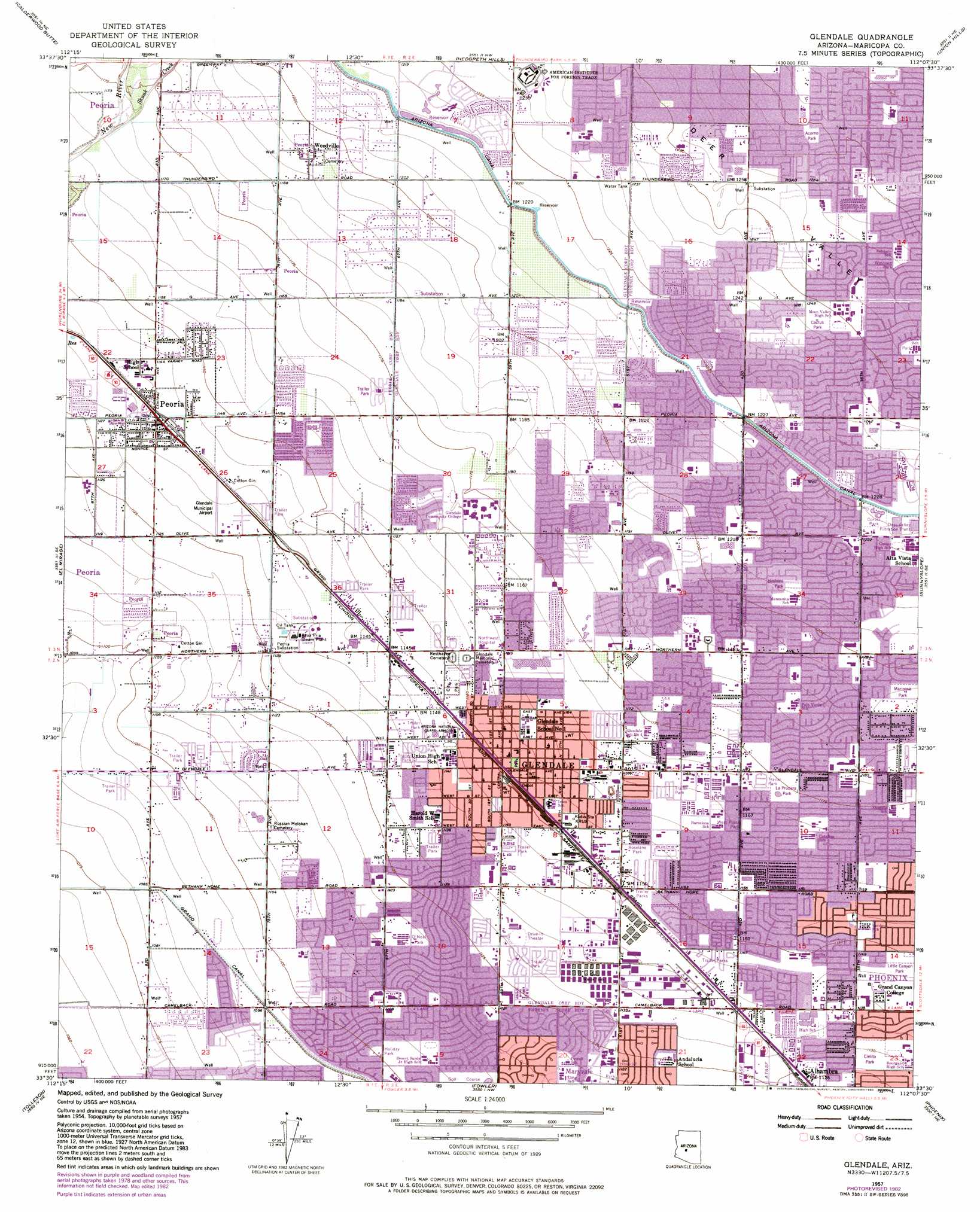
USGS Topo Quad 33112e2 - 1:24,000 scale
| Topo Map Name: | Glendale |
| USGS Topo Quad ID: | 33112e2 |
| Print Size: | ca. 21 1/4" wide x 27" high |
| Southeast Coordinates: | 33.5° N latitude / 112.125° W longitude |
| Map Center Coordinates: | 33.5625° N latitude / 112.1875° W longitude |
| U.S. State: | AZ |
| Filename: | o33112e2.jpg |
| Download Map JPG Image: | Glendale topo map 1:24,000 scale |
| Map Type: | Topographic |
| Topo Series: | 7.5´ |
| Map Scale: | 1:24,000 |
| Source of Map Images: | United States Geological Survey (USGS) |
| Alternate Map Versions: |
Glendale AZ 1957, updated 1958 Download PDF Buy paper map Glendale AZ 1957, updated 1965 Download PDF Buy paper map Glendale AZ 1957, updated 1972 Download PDF Buy paper map Glendale AZ 1957, updated 1977 Download PDF Buy paper map Glendale AZ 1957, updated 1983 Download PDF Buy paper map Glendale AZ 1957, updated 1983 Download PDF Buy paper map Glendale AZ 1971, updated 1972 Download PDF Buy paper map Glendale AZ 2011 Download PDF Buy paper map Glendale AZ 2014 Download PDF Buy paper map |
1:24,000 Topo Quads surrounding Glendale
Hieroglyphic Mountains Sw |
Baldy Mountain |
Biscuit Flat |
New River Se |
Cave Creek |
Mcmicken Dam |
Calderwood Butte |
Hedgpeth Hills |
Union Hills |
Currys Corner |
Waddell |
El Mirage |
Glendale |
Sunnyslope |
Paradise Valley |
Perryville |
Tolleson |
Fowler |
Phoenix |
Tempe |
Avondale Sw |
Avondale Se |
Laveen |
Lone Butte |
Guadalupe |
> Back to 33112e1 at 1:100,000 scale
> Back to 33112a1 at 1:250,000 scale
> Back to U.S. Topo Maps home
Glendale topo map: Gazetteer
Glendale: Airports
Airscrew Performance Ultralight Flightpark elevation 339m 1112′Glendale Municipal Airport elevation 346m 1135′
Sunstate-Glendale Helistop elevation 346m 1135′
Glendale: Parks
Acoma Park elevation 379m 1243′Acorno Park elevation 389m 1276′
Bicentennial Park elevation 339m 1112′
Braewood Park elevation 345m 1131′
Cactus Park elevation 380m 1246′
Central Park elevation 347m 1138′
Cholla Park elevation 368m 1207′
Cielito Park elevation 390m 1279′
Cielito Park elevation 344m 1128′
Cortez Park elevation 374m 1227′
Cortez Park elevation 374m 1227′
Country Gable Park elevation 394m 1292′
Country Gables Park elevation 381m 1250′
Delicias Park elevation 358m 1174′
Glendale Community Park elevation 347m 1138′
Holiday Park elevation 336m 1102′
Horizon Park elevation 365m 1197′
Hoshoni Park elevation 368m 1207′
La Prudera Park elevation 358m 1174′
Las Palmaritas Park elevation 386m 1266′
Lawrence Park elevation 349m 1145′
Little Canyon Park elevation 350m 1148′
Mariposa Park elevation 365m 1197′
Maryvale Park elevation 342m 1122′
Mission Park elevation 366m 1200′
Murphy Park elevation 352m 1154′
Myrtle Park elevation 355m 1164′
New World Park elevation 364m 1194′
O'Neal Park elevation 342m 1122′
Roselane Park elevation 352m 1154′
Rovey Park elevation 356m 1167′
Sunset Park elevation 369m 1210′
Varney Park elevation 350m 1148′
W J Murphy Park elevation 352m 1154′
West Plaza Park elevation 356m 1167′
Westown Park elevation 386m 1266′
Windsor Park elevation 340m 1115′
Glendale: Populated Places
Belaire Manor elevation 346m 1135′Bethany Grand Mobile Home Park elevation 352m 1154′
Bethany Villa Adult Mobile Home Park elevation 352m 1154′
Blue Sky Mobile Estates elevation 355m 1164′
Braemar VII elevation 355m 1164′
Bristol Square elevation 364m 1194′
Cactus Gale V elevation 376m 1233′
Casa del Sol Resorts elevation 357m 1171′
Cheyenne Village elevation 384m 1259′
Cottonwood Ranch elevation 357m 1171′
Deer Creek elevation 354m 1161′
Dunhill Meadows elevation 332m 1089′
Fairwood VIII elevation 358m 1174′
Flamingo Mobile Home Resort elevation 351m 1151′
Fox Glen elevation 357m 1171′
Glendale elevation 351m 1151′
Glendale West Mobile Home Park elevation 338m 1108′
Grand Missouri Adult Mobile Home Park elevation 351m 1151′
Greenbriar elevation 370m 1213′
Hoka Tiki Mobile Village elevation 352m 1154′
Indian Springs elevation 335m 1099′
Ironwood Terrace elevation 339m 1112′
La Fontana Heights elevation 337m 1105′
Lazy J Trailer Lodge elevation 347m 1138′
Leisure Time Mobile Park elevation 349m 1145′
Longhaven West elevation 344m 1128′
Longhorn Ranch II elevation 364m 1194′
Marlborough Meadows elevation 369m 1210′
Maryland West Mobile Home Park elevation 349m 1145′
Maryvale elevation 341m 1118′
Midges Court elevation 349m 1145′
Montara elevation 365m 1197′
Mountain View Meadows elevation 354m 1161′
Olive West elevation 350m 1148′
Palm Shadows Mobile Home Park elevation 357m 1171′
Palmaritas elevation 369m 1210′
Paradise Grove Family Park elevation 348m 1141′
Paradise Grove Trailer Park elevation 350m 1148′
Pensfield Place elevation 359m 1177′
Peoria elevation 348m 1141′
Peoria Estates elevation 348m 1141′
Pepper Tree Mobile Home Park elevation 346m 1135′
Phoenix West Mobile Home Park elevation 361m 1184′
Pioneer Village II elevation 354m 1161′
Purple Sage Mobile Home Park elevation 347m 1138′
Quail Lane elevation 361m 1184′
Rambling Rons Mobile Home Park elevation 352m 1154′
Roles Inn of America elevation 358m 1174′
Rose Terrace Trailer Park elevation 349m 1145′
Royal Estates West elevation 370m 1213′
Royal Glen Mobile Home Park elevation 360m 1181′
Sahara Mobile Home Park elevation 358m 1174′
San Miguel elevation 373m 1223′
Santa Grande Mobile Home Park elevation 350m 1148′
Santa Maria elevation 367m 1204′
Shamrock Mobile Home Park elevation 333m 1092′
Sunray Manor elevation 387m 1269′
The Citadel elevation 354m 1161′
Three Fountains elevation 344m 1128′
Thunderbird Palms II elevation 372m 1220′
Tiki Tai Village elevation 350m 1148′
Triple T Mobilcity elevation 347m 1138′
Village Park elevation 359m 1177′
Weedville elevation 365m 1197′
Wellington Court elevation 362m 1187′
Westcliff Park elevation 384m 1259′
Westerra elevation 367m 1204′
Westwind elevation 363m 1190′
WillowBrook II elevation 364m 1194′
Windmill elevation 355m 1164′
Windsor Square elevation 361m 1184′
Glendale: Post Offices
Glendale Post Office elevation 362m 1187′Glendale Post Office elevation 352m 1154′
Maryvale Post Office elevation 341m 1118′
Peoria Post Office elevation 345m 1131′
Glendale: Streams
Skunk Creek elevation 354m 1161′Glendale: Valleys
Deer Valley elevation 380m 1246′Glendale digital topo map on disk
Buy this Glendale topo map showing relief, roads, GPS coordinates and other geographical features, as a high-resolution digital map file on DVD: