Kofa Butte Topo Map Arizona
To zoom in, hover over the map of Kofa Butte
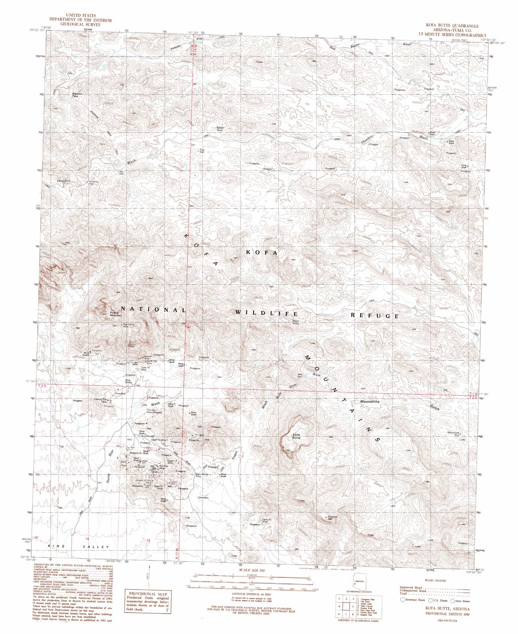
USGS Topo Quad 33113c8 - 1:24,000 scale
| Topo Map Name: | Kofa Butte |
| USGS Topo Quad ID: | 33113c8 |
| Print Size: | ca. 21 1/4" wide x 27" high |
| Southeast Coordinates: | 33.25° N latitude / 113.875° W longitude |
| Map Center Coordinates: | 33.3125° N latitude / 113.9375° W longitude |
| U.S. State: | AZ |
| Filename: | o33113c8.jpg |
| Download Map JPG Image: | Kofa Butte topo map 1:24,000 scale |
| Map Type: | Topographic |
| Topo Series: | 7.5´ |
| Map Scale: | 1:24,000 |
| Source of Map Images: | United States Geological Survey (USGS) |
| Alternate Map Versions: |
Kofa Butte AZ 1990, updated 1990 Download PDF Buy paper map Kofa Butte AZ 2011 Download PDF Buy paper map Kofa Butte AZ 2014 Download PDF Buy paper map |
1:24,000 Topo Quads surrounding Kofa Butte
South Of Quartzsite |
Crystal Hill |
New Water Mountains |
New Water Well |
Hope Sw |
Livingston Hills Nw |
Livingston Hills |
Owl Head |
Cholla Tank |
Coyote Peak |
Stone Cabin |
Palm Canyon |
Kofa Butte |
Hoodoo Well |
Cementosa Wash |
Arch Tank |
Kofa Deep Well |
Charlie Died Tank |
Engesser Pass |
Palomas Mountains Nw |
Castle Dome Peak |
Slumgullion Pass |
Engesser Pass Sw |
Neversweat Ridge |
Palomas Mountains Sw |
> Back to 33113a1 at 1:100,000 scale
> Back to 33112a1 at 1:250,000 scale
> Back to U.S. Topo Maps home
Kofa Butte topo map: Gazetteer
Kofa Butte: Arches
Natural Arch elevation 685m 2247′Kofa Butte: Dams
Kofa Dam elevation 658m 2158′Kofa Butte: Gaps
Big Horn Pass elevation 936m 3070′Kofa Butte: Mines
Baker Mine elevation 529m 1735′Black Dahlia Mine elevation 523m 1715′
C O D Mine elevation 766m 2513′
Eagle Mine elevation 580m 1902′
Evening Star Mine elevation 551m 1807′
High Henry Mine elevation 965m 3166′
I X L Mine elevation 853m 2798′
King of Arizona Mine elevation 569m 1866′
North Star Mine elevation 589m 1932′
Rob Roy Mine elevation 558m 1830′
Kofa Butte: Reservoirs
Moonshine Tank elevation 630m 2066′Raven Tank elevation 826m 2709′
Yaqui Tanks elevation 719m 2358′
Kofa Butte: Streams
Kofa Dam Wash elevation 575m 1886′North Star Wash elevation 461m 1512′
Yaqui Wash elevation 491m 1610′
Kofa Butte: Summits
Kofa Butte elevation 973m 3192′Kofa Mountains elevation 842m 2762′
Polaris Mountain elevation 1099m 3605′
Kofa Butte: Wells
Deep Well elevation 487m 1597′Dry Well elevation 887m 2910′
King Well elevation 829m 2719′
Mid Well elevation 874m 2867′
North Star Well elevation 464m 1522′
Rob Roy Well elevation 537m 1761′
Wilbanks Well elevation 903m 2962′
Kofa Butte digital topo map on disk
Buy this Kofa Butte topo map showing relief, roads, GPS coordinates and other geographical features, as a high-resolution digital map file on DVD: