Harquahala Mountain Topo Map Arizona
To zoom in, hover over the map of Harquahala Mountain
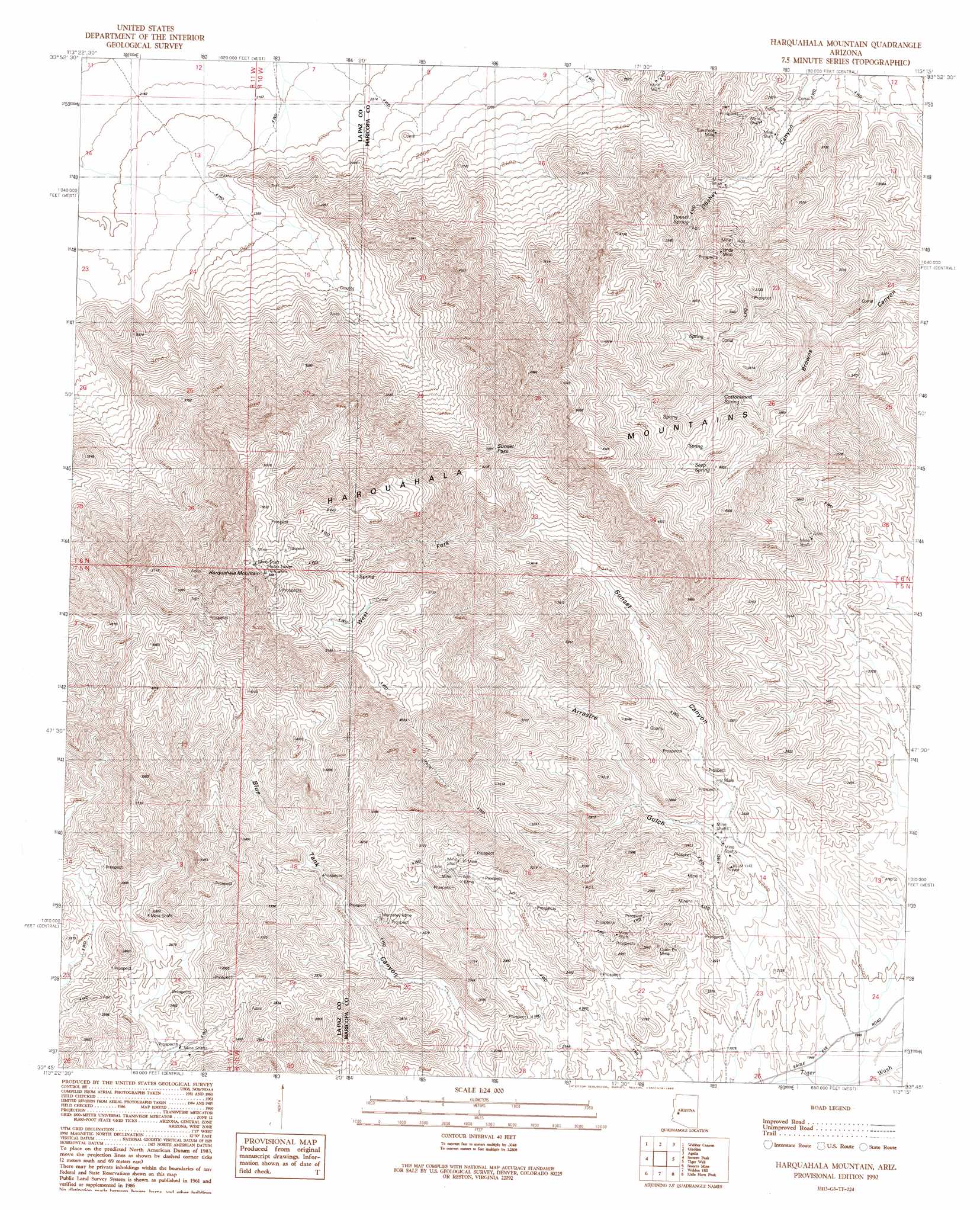
USGS Topo Quad 33113g3 - 1:24,000 scale
| Topo Map Name: | Harquahala Mountain |
| USGS Topo Quad ID: | 33113g3 |
| Print Size: | ca. 21 1/4" wide x 27" high |
| Southeast Coordinates: | 33.75° N latitude / 113.25° W longitude |
| Map Center Coordinates: | 33.8125° N latitude / 113.3125° W longitude |
| U.S. State: | AZ |
| Filename: | o33113g3.jpg |
| Download Map JPG Image: | Harquahala Mountain topo map 1:24,000 scale |
| Map Type: | Topographic |
| Topo Series: | 7.5´ |
| Map Scale: | 1:24,000 |
| Source of Map Images: | United States Geological Survey (USGS) |
| Alternate Map Versions: |
Harquahala Mountain AZ 1990, updated 1990 Download PDF Buy paper map Harquahala Mountain AZ 2011 Download PDF Buy paper map Harquahala Mountain AZ 2014 Download PDF Buy paper map |
1:24,000 Topo Quads surrounding Harquahala Mountain
Alamo Dam Se |
E C P Peak |
Smith Peak |
Date Creek Ranch Sw |
Date Creek Ranch Se |
Cunningham Pass |
Webber Canyon |
Gladden |
Aguila |
Forepaugh Peak |
Salome |
Socorro Peak |
Harquahala Mountain |
Tiger Well |
Black Butte |
Harrisburg Valley |
Socorro Mine |
Weldon Hill |
Little Horn Peak |
Hummingbird Spring |
Hope Se |
Lone Mountain |
Courthouse Well |
Big Horn Peak |
Burnt Mountain |
> Back to 33113e1 at 1:100,000 scale
> Back to 33112a1 at 1:250,000 scale
> Back to U.S. Topo Maps home
Harquahala Mountain topo map: Gazetteer
Harquahala Mountain: Gaps
Sunset Pass elevation 1177m 3861′Harquahala Mountain: Mines
Carmelita Mines elevation 703m 2306′Linda Mine elevation 1128m 3700′
Monterey Mine elevation 882m 2893′
Sunshine Mine elevation 992m 3254′
Harquahala Mountain: Ranges
Harquahala Mountains elevation 1556m 5104′Harquahala Mountain: Springs
Cottonwood Spring elevation 1051m 3448′Seep Spring elevation 0m 0′
Tunnel Spring elevation 1023m 3356′
Harquahala Mountain: Summits
Harquahala Mountain elevation 1705m 5593′Harquahala Mountain: Valleys
Arrastre Gulch elevation 637m 2089′Sunset Canyon elevation 658m 2158′
West Fork Sunset Canyon elevation 961m 3152′
Harquahala Mountain digital topo map on disk
Buy this Harquahala Mountain topo map showing relief, roads, GPS coordinates and other geographical features, as a high-resolution digital map file on DVD: