Palm Canyon Topo Map Arizona
To zoom in, hover over the map of Palm Canyon
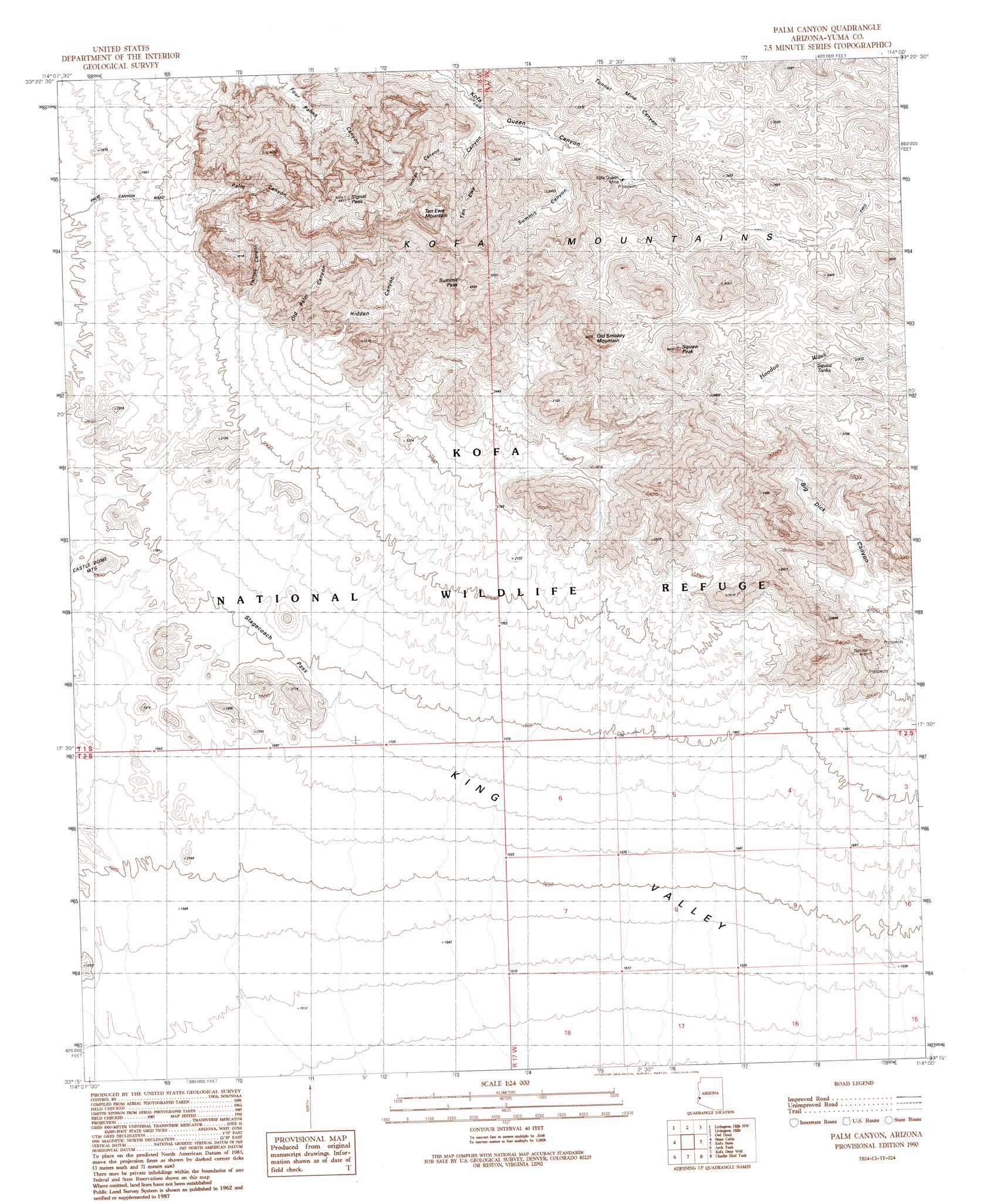
USGS Topo Quad 33114c1 - 1:24,000 scale
| Topo Map Name: | Palm Canyon |
| USGS Topo Quad ID: | 33114c1 |
| Print Size: | ca. 21 1/4" wide x 27" high |
| Southeast Coordinates: | 33.25° N latitude / 114° W longitude |
| Map Center Coordinates: | 33.3125° N latitude / 114.0625° W longitude |
| U.S. State: | AZ |
| Filename: | o33114c1.jpg |
| Download Map JPG Image: | Palm Canyon topo map 1:24,000 scale |
| Map Type: | Topographic |
| Topo Series: | 7.5´ |
| Map Scale: | 1:24,000 |
| Source of Map Images: | United States Geological Survey (USGS) |
| Alternate Map Versions: |
Palm Canyon AZ 1990, updated 1990 Download PDF Buy paper map Palm Canyon AZ 2011 Download PDF Buy paper map Palm Canyon AZ 2014 Download PDF Buy paper map |
1:24,000 Topo Quads surrounding Palm Canyon
Cunningham Mountain |
South Of Quartzsite |
Crystal Hill |
New Water Mountains |
New Water Well |
Trigo Pass |
Livingston Hills Nw |
Livingston Hills |
Owl Head |
Cholla Tank |
Tweed Mine |
Stone Cabin |
Palm Canyon |
Kofa Butte |
Hoodoo Well |
Red Hill Ne |
Arch Tank |
Kofa Deep Well |
Charlie Died Tank |
Engesser Pass |
Middle Mountains North |
Castle Dome Peak |
Slumgullion Pass |
Engesser Pass Sw |
Neversweat Ridge |
> Back to 33114a1 at 1:100,000 scale
> Back to 33114a1 at 1:250,000 scale
> Back to U.S. Topo Maps home
Palm Canyon topo map: Gazetteer
Palm Canyon: Arches
Natural Arch elevation 747m 2450′Palm Canyon: Gaps
Stagecoach Pass elevation 554m 1817′Palm Canyon: Mines
Kofa Queen Mine elevation 964m 3162′Palm Canyon: Parks
Kofa Game Range elevation 450m 1476′Palm Canyon: Pillars
Squaw Peak elevation 1240m 4068′Palm Canyon: Reservoirs
Squaw Tanks elevation 975m 3198′Palm Canyon: Summits
Old Smokey Mountain elevation 1307m 4288′Signal Peak elevation 0m 0′
Summit Peak elevation 1308m 4291′
Ten Ewe Mountain elevation 1437m 4714′
Palm Canyon: Valleys
Big Dick Canyon elevation 613m 2011′Fishtail Canyon elevation 640m 2099′
Hidden Canyon elevation 700m 2296′
Indian Canyon elevation 894m 2933′
Old Palm Canyon elevation 654m 2145′
Palm Canyon elevation 641m 2103′
Summit Canyon elevation 926m 3038′
Ten Ewe Canyon elevation 870m 2854′
Palm Canyon digital topo map on disk
Buy this Palm Canyon topo map showing relief, roads, GPS coordinates and other geographical features, as a high-resolution digital map file on DVD: