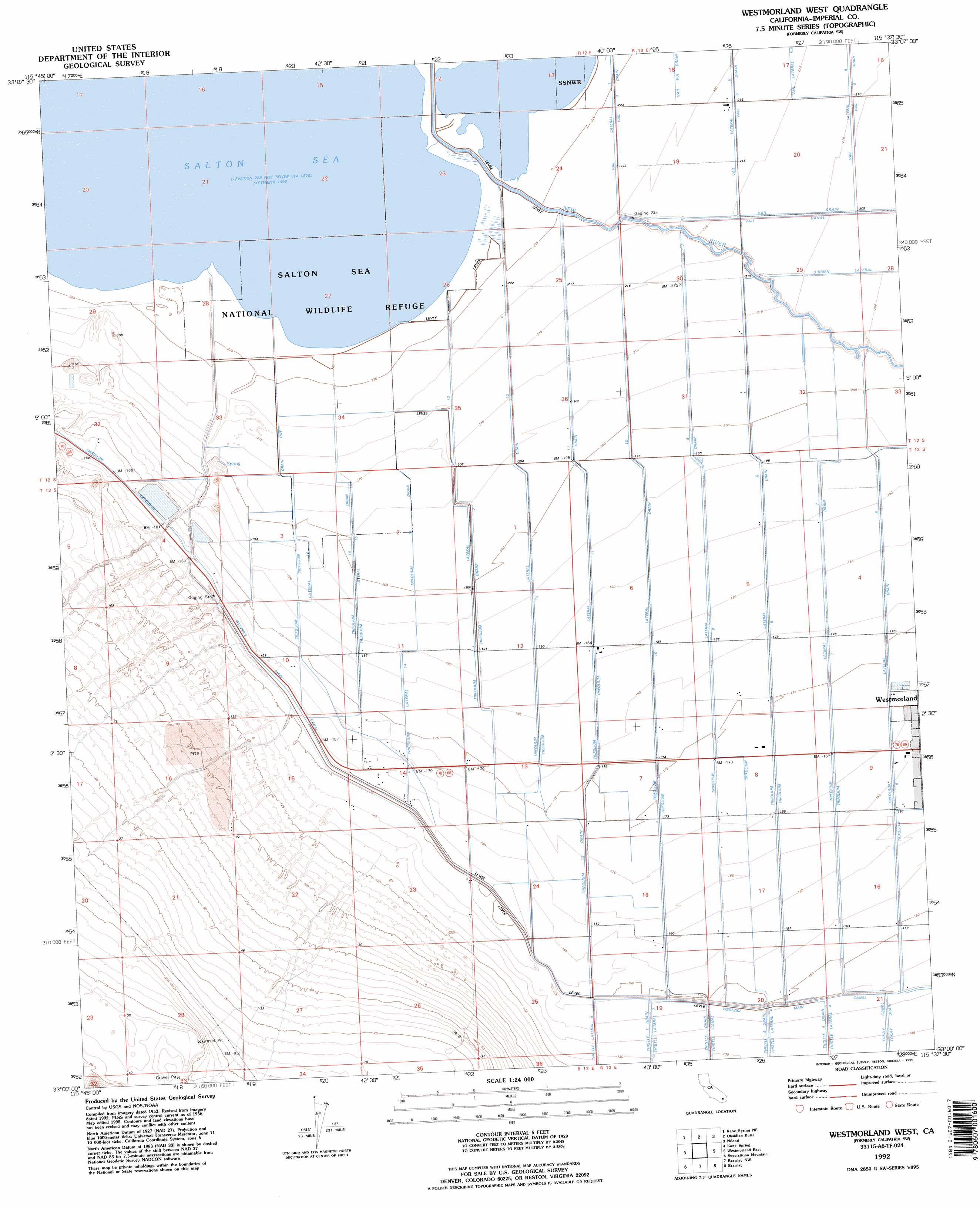
Westmorland West Topo Map California
To zoom in, hover over the map of Westmorland West
USGS Topo Quad 33115a6 - 1:24,000 scale
| Topo Map Name: | Westmorland West |
| USGS Topo Quad ID: | 33115a6 |
| Print Size: | ca. 21 1/4" wide x 27" high |
| Southeast Coordinates: | 33° N latitude / 115.625° W longitude |
| Map Center Coordinates: | 33.0625° N latitude / 115.6875° W longitude |
| U.S. State: | CA |
| Filename: | o33115a6.jpg |
| Download Map JPG Image: | Westmorland West topo map 1:24,000 scale |
| Map Type: | Topographic |
| Topo Series: | 7.5´ |
| Map Scale: | 1:24,000 |
| Source of Map Images: | United States Geological Survey (USGS) |
| Alternate Map Versions: |
Calipatria SW CA 1956, updated 1958 Download PDF Buy paper map Calipatria SW CA 1956, updated 1966 Download PDF Buy paper map Calipatria SW CA 1956, updated 1966 Download PDF Buy paper map Calipatria SW CA 1956, updated 1979 Download PDF Buy paper map Westmorland West CA 1992, updated 1995 Download PDF Buy paper map Westmorland West CA 1992, updated 1995 Download PDF Buy paper map Westmorland West CA 2012 Download PDF Buy paper map Westmorland West CA 2015 Download PDF Buy paper map |
1:24,000 Topo Quads surrounding Westmorland West
Truckhaven |
Durmid Se |
Frink |
Wister |
Iris Wash |
Kane Spring Nw |
Kane Spring Ne |
Obsidian Butte |
Niland |
Iris |
Harpers Well |
Kane Spring |
Westmorland West |
Westmorland East |
Wiest |
Plaster City Nw |
Superstition Mountain |
Brawley Nw |
Brawley |
Alamorio |
Painted Gorge |
Plaster City |
Seeley |
El Centro |
Holtville West |
> Back to 33115a1 at 1:100,000 scale
> Back to 33114a1 at 1:250,000 scale
> Back to U.S. Topo Maps home
Westmorland West topo map: Gazetteer
Westmorland West: Canals
O'Brien Lateral elevation -61m -201′Thompson Drain elevation -63m -207′
Trifolium Drain 2 elevation -61m -201′
Trifolium Drain One elevation -65m -214′
Trifolium Eight Drain elevation -54m -178′
Trifolium Eleven Drain elevation -59m -194′
Trifolium Fifteen Drain elevation -60m -197′
Trifolium Fourteen Drain elevation -61m -201′
Trifolium Lateral elevation -59m -194′
Trifolium Lateral Eight elevation -53m -174′
Trifolium Lateral Eleven elevation -57m -188′
Trifolium Lateral Fifteen elevation -59m -194′
Trifolium Lateral Fourteen elevation -52m -171′
Trifolium Lateral Nine elevation -54m -178′
Trifolium Lateral Seven elevation -52m -171′
Trifolium Lateral Six elevation -52m -171′
Trifolium Lateral Sixteen elevation -57m -188′
Trifolium Lateral Ten elevation -54m -178′
Trifolium Lateral Twelve elevation -59m -194′
Trifolium Nine Drain elevation -57m -188′
Trifolium Seven Drain elevation -53m -174′
Trifolium Six Drain elevation -51m -168′
Trifolium Storm Drain elevation -47m -155′
Trifolium Ten Drain elevation -55m -181′
Trifolium Twelve Drain elevation -61m -201′
Vail Canal elevation -64m -210′
Vail Five Drain elevation -63m -207′
Vail Seven Drain elevation -67m -220′
Vail Six-A Drain elevation -64m -210′
Westmorland West digital topo map on disk
Buy this Westmorland West topo map showing relief, roads, GPS coordinates and other geographical features, as a high-resolution digital map file on DVD: