Victory Pass Topo Map California
To zoom in, hover over the map of Victory Pass
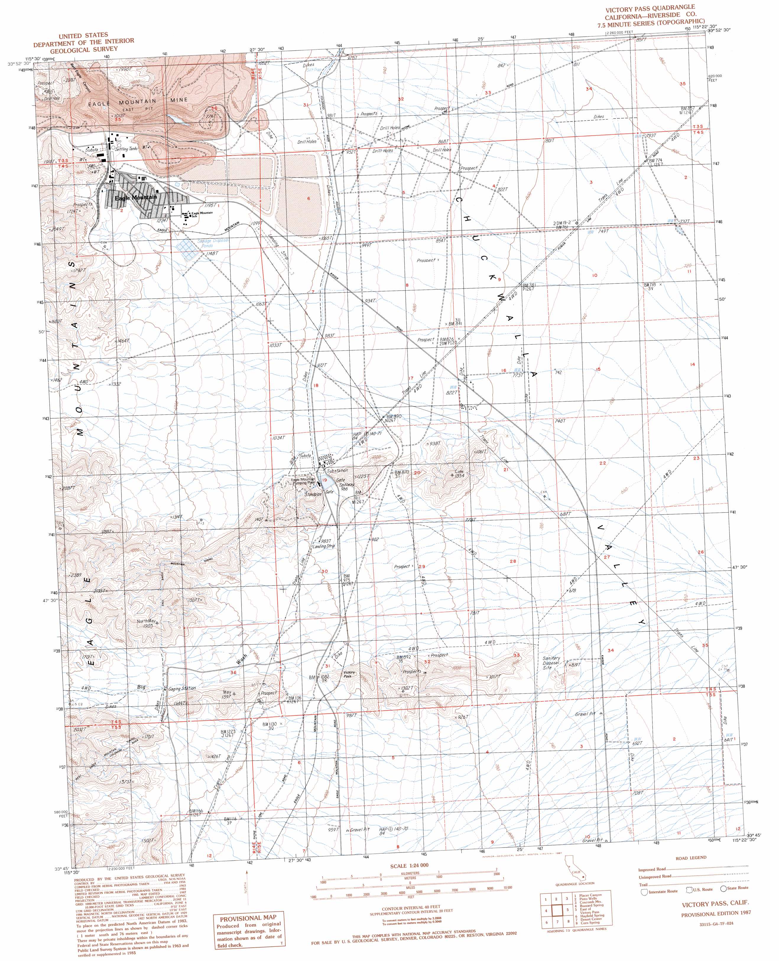
USGS Topo Quad 33115g4 - 1:24,000 scale
| Topo Map Name: | Victory Pass |
| USGS Topo Quad ID: | 33115g4 |
| Print Size: | ca. 21 1/4" wide x 27" high |
| Southeast Coordinates: | 33.75° N latitude / 115.375° W longitude |
| Map Center Coordinates: | 33.8125° N latitude / 115.4375° W longitude |
| U.S. State: | CA |
| Filename: | o33115g4.jpg |
| Download Map JPG Image: | Victory Pass topo map 1:24,000 scale |
| Map Type: | Topographic |
| Topo Series: | 7.5´ |
| Map Scale: | 1:24,000 |
| Source of Map Images: | United States Geological Survey (USGS) |
| Alternate Map Versions: |
Victory Pass CA 1987, updated 1987 Download PDF Buy paper map Victory Pass CA 2012 Download PDF Buy paper map Victory Pass CA 2015 Download PDF Buy paper map |
1:24,000 Topo Quads surrounding Victory Pass
New Dale |
Clarks Pass |
Cadiz Valley Sw |
Cadiz Valley Se |
Granite Pass |
San Bernardino Wash |
Placer Canyon |
Pinto Wells |
Coxcomb Mountains |
West Of Palen Pass |
Conejo Well |
Buzzard Spring |
Victory Pass |
East Of Victory Pass |
Palen Lake |
Hayfield |
Hayfield Spring |
Desert Center |
Corn Spring |
Sidewinder Well |
Red Canyon |
East Of Red Canyon |
Red Cloud Canyon |
Pilot Mountain |
Aztec Mines |
> Back to 33115e1 at 1:100,000 scale
> Back to 33114a1 at 1:250,000 scale
> Back to U.S. Topo Maps home
Victory Pass topo map: Gazetteer
Victory Pass: Airports
Eagle Mountain Pump Plant Landing Strip elevation 300m 984′Victory Pass: Gaps
Victory Pass elevation 328m 1076′Victory Pass: Mines
Eagle Mountain Mine elevation 439m 1440′East Pit Eagle Mountain Mine elevation 305m 1000′
Victory Pass: Populated Places
Eagle Mountain elevation 416m 1364′Victory Pass: Streams
Eagle Creek elevation 230m 754′Victory Pass: Tunnels
East Eagle Mountain Tunnel elevation 465m 1525′Victory Pass: Valleys
Bald Eagle Canyon elevation 444m 1456′Victory Pass digital topo map on disk
Buy this Victory Pass topo map showing relief, roads, GPS coordinates and other geographical features, as a high-resolution digital map file on DVD: