Earthquake Valley Topo Map California
To zoom in, hover over the map of Earthquake Valley
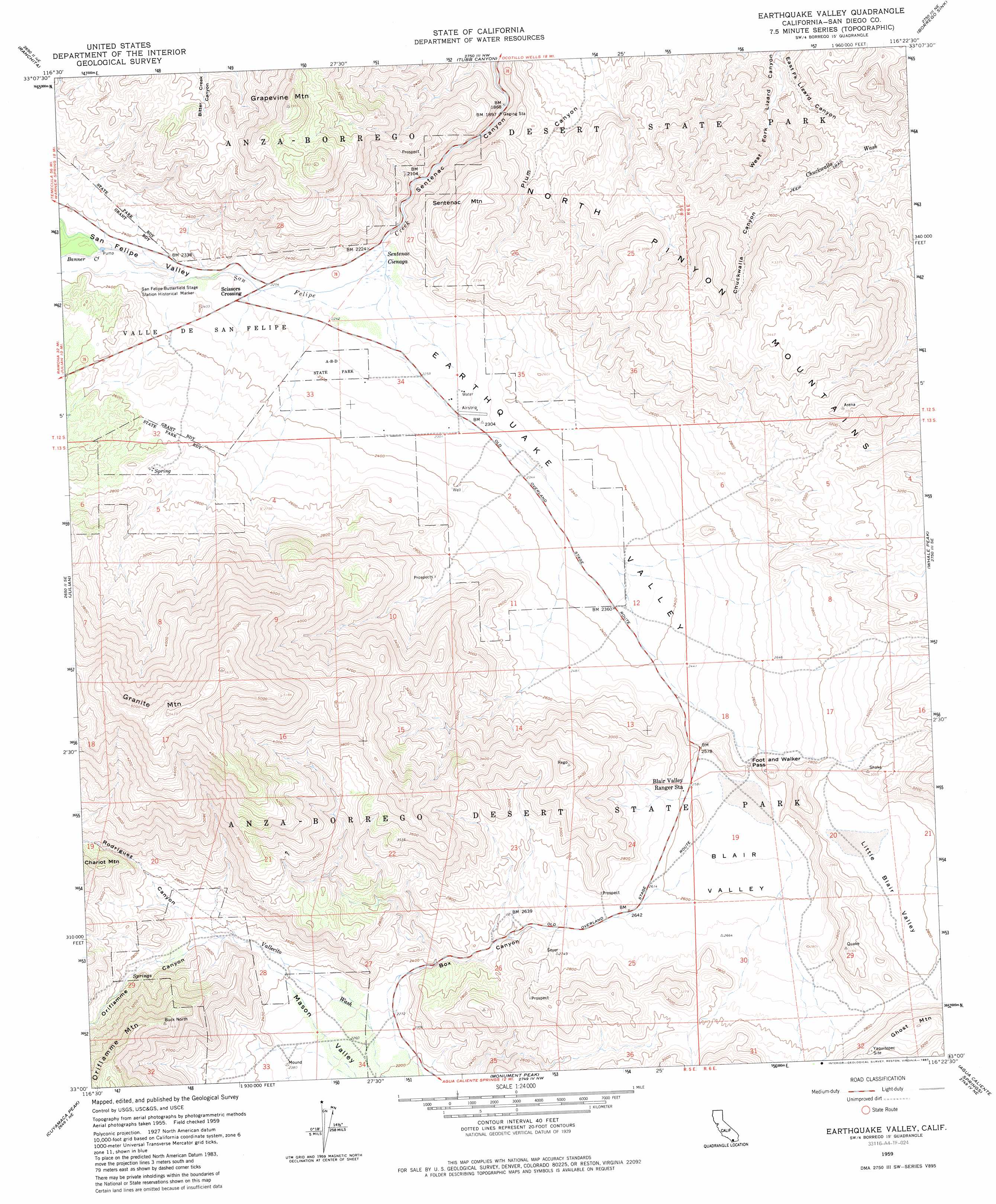
USGS Topo Quad 33116a4 - 1:24,000 scale
| Topo Map Name: | Earthquake Valley |
| USGS Topo Quad ID: | 33116a4 |
| Print Size: | ca. 21 1/4" wide x 27" high |
| Southeast Coordinates: | 33° N latitude / 116.375° W longitude |
| Map Center Coordinates: | 33.0625° N latitude / 116.4375° W longitude |
| U.S. State: | CA |
| Filename: | o33116a4.jpg |
| Download Map JPG Image: | Earthquake Valley topo map 1:24,000 scale |
| Map Type: | Topographic |
| Topo Series: | 7.5´ |
| Map Scale: | 1:24,000 |
| Source of Map Images: | United States Geological Survey (USGS) |
| Alternate Map Versions: |
Earthquake Valley CA 1959, updated 1960 Download PDF Buy paper map Earthquake Valley CA 1959, updated 1967 Download PDF Buy paper map Earthquake Valley CA 1959, updated 1967 Download PDF Buy paper map Earthquake Valley CA 1959, updated 1980 Download PDF Buy paper map Earthquake Valley CA 1959, updated 1987 Download PDF Buy paper map Earthquake Valley CA 2012 Download PDF Buy paper map Earthquake Valley CA 2015 Download PDF Buy paper map |
1:24,000 Topo Quads surrounding Earthquake Valley
Warner Springs |
Hot Springs Mountain |
Borrego Palm Canyon |
Clark Lake |
Fonts Point |
Warners Ranch |
Ranchita |
Tubb Canyon |
Borrego Sink |
Borrego Mountain |
Santa Ysabel |
Julian |
Earthquake Valley |
Whale Peak |
Harper Canyon |
Tule Springs |
Cuyamaca Peak |
Monument Peak |
Agua Caliente Springs |
Arroyo Tapiado |
Viejas Mountain |
Descanso |
Mount Laguna |
Sombrero Peak |
Sweeney Pass |
> Back to 33116a1 at 1:100,000 scale
> Back to 33116a1 at 1:250,000 scale
> Back to U.S. Topo Maps home
Earthquake Valley topo map: Gazetteer
Earthquake Valley: Airports
Hunts Sky Ranch elevation 698m 2290′Earthquake Valley: Basins
Blair Valley elevation 773m 2536′Little Blair Valley elevation 834m 2736′
Earthquake Valley: Gaps
Foot and Walker Pass elevation 790m 2591′Earthquake Valley: Populated Places
Scissors Crossing elevation 699m 2293′Earthquake Valley: Ranges
North Pinyon Mountains elevation 1079m 3540′Earthquake Valley: Streams
Banner Creek elevation 720m 2362′Oriflamme Creek elevation 781m 2562′
San Felipe Creek elevation 679m 2227′
Earthquake Valley: Summits
Ghost Mountain elevation 1033m 3389′Granite Mountain elevation 1711m 5613′
Grapevine Mountain elevation 1192m 3910′
Sentenac Mountain elevation 930m 3051′
Earthquake Valley: Swamps
Sentence Cienaga elevation 679m 2227′Earthquake Valley: Trails
Old Overland Stage Route elevation 792m 2598′Earthquake Valley: Valleys
Box Canyon elevation 701m 2299′Chuckwalla Canyon elevation 595m 1952′
Earthquake Valley elevation 679m 2227′
East Fork Lizard Canyon elevation 550m 1804′
Oriflamme Canyon elevation 789m 2588′
Rodriguez Canyon elevation 777m 2549′
San Felipe Valley elevation 681m 2234′
West Fork Lizard Canyon elevation 544m 1784′
Earthquake Valley digital topo map on disk
Buy this Earthquake Valley topo map showing relief, roads, GPS coordinates and other geographical features, as a high-resolution digital map file on DVD: