San Pasqual Topo Map California
To zoom in, hover over the map of San Pasqual
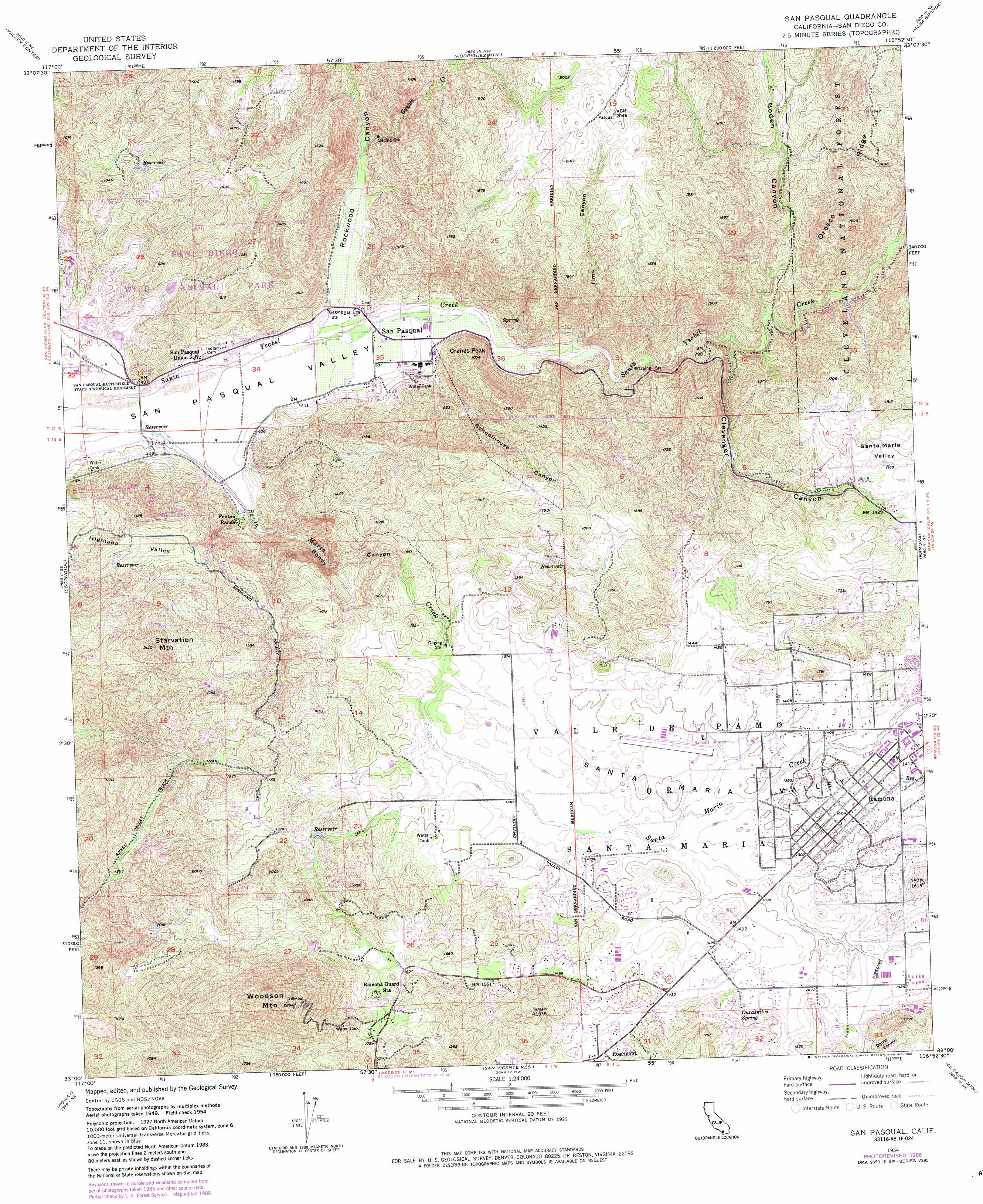
USGS Topo Quad 33116a8 - 1:24,000 scale
| Topo Map Name: | San Pasqual |
| USGS Topo Quad ID: | 33116a8 |
| Print Size: | ca. 21 1/4" wide x 27" high |
| Southeast Coordinates: | 33° N latitude / 116.875° W longitude |
| Map Center Coordinates: | 33.0625° N latitude / 116.9375° W longitude |
| U.S. State: | CA |
| Filename: | o33116a8.jpg |
| Download Map JPG Image: | San Pasqual topo map 1:24,000 scale |
| Map Type: | Topographic |
| Topo Series: | 7.5´ |
| Map Scale: | 1:24,000 |
| Source of Map Images: | United States Geological Survey (USGS) |
| Alternate Map Versions: |
San Pasqual CA 1954, updated 1957 Download PDF Buy paper map San Pasqual CA 1954, updated 1961 Download PDF Buy paper map San Pasqual CA 1954, updated 1973 Download PDF Buy paper map San Pasqual CA 1954, updated 1984 Download PDF Buy paper map San Pasqual CA 1954, updated 1988 Download PDF Buy paper map San Pasqual CA 1997, updated 2000 Download PDF Buy paper map San Pasqual CA 2012 Download PDF Buy paper map San Pasqual CA 2015 Download PDF Buy paper map |
| FStopo: | US Forest Service topo San Pasqual is available: Download FStopo PDF Download FStopo TIF |
1:24,000 Topo Quads surrounding San Pasqual
Bonsall |
Pala |
Boucher Hill |
Palomar Observatory |
Warner Springs |
San Marcos |
Valley Center |
Rodriguez Mountain |
Mesa Grande |
Warners Ranch |
Rancho Santa Fe |
Escondido |
San Pasqual |
Ramona |
Santa Ysabel |
Del Mar |
Poway |
San Vicente Reservoir |
El Cajon Mountain |
Tule Springs |
La Jolla |
La Mesa |
El Cajon |
Alpine |
Viejas Mountain |
> Back to 33116a1 at 1:100,000 scale
> Back to 33116a1 at 1:250,000 scale
> Back to U.S. Topo Maps home
San Pasqual topo map: Gazetteer
San Pasqual: Airports
Ramona Airport elevation 424m 1391′San Pasqual: Dams
Mount Woodson 1044 Dam elevation 513m 1683′San Pasqual: Parks
San Diego Wild Animal Park elevation 237m 777′San Pasqual Battlefield State Historic Park elevation 123m 403′
San Pasqual: Populated Places
Rosemont elevation 451m 1479′San Pasqual elevation 131m 429′
San Pasqual: Ridges
Orosco Ridge elevation 547m 1794′San Pasqual: Springs
Durasnitos Spring elevation 445m 1459′San Pasqual: Streams
Guejito Creek elevation 142m 465′San Pasqual: Summits
Cranes Peak elevation 310m 1017′Starvation Mountain elevation 641m 2103′
Woodson Mountain elevation 878m 2880′
San Pasqual: Trails
Green Valley Truck Trail elevation 383m 1256′San Pasqual: Valleys
Bandy Canyon elevation 126m 413′Boden Canyon elevation 219m 718′
Clevenger Canyon elevation 205m 672′
Rockwood Canyon elevation 126m 413′
Santa Maria Valley elevation 427m 1400′
Schoolhouse Canyon elevation 143m 469′
Tims Canyon elevation 145m 475′
San Pasqual digital topo map on disk
Buy this San Pasqual topo map showing relief, roads, GPS coordinates and other geographical features, as a high-resolution digital map file on DVD: