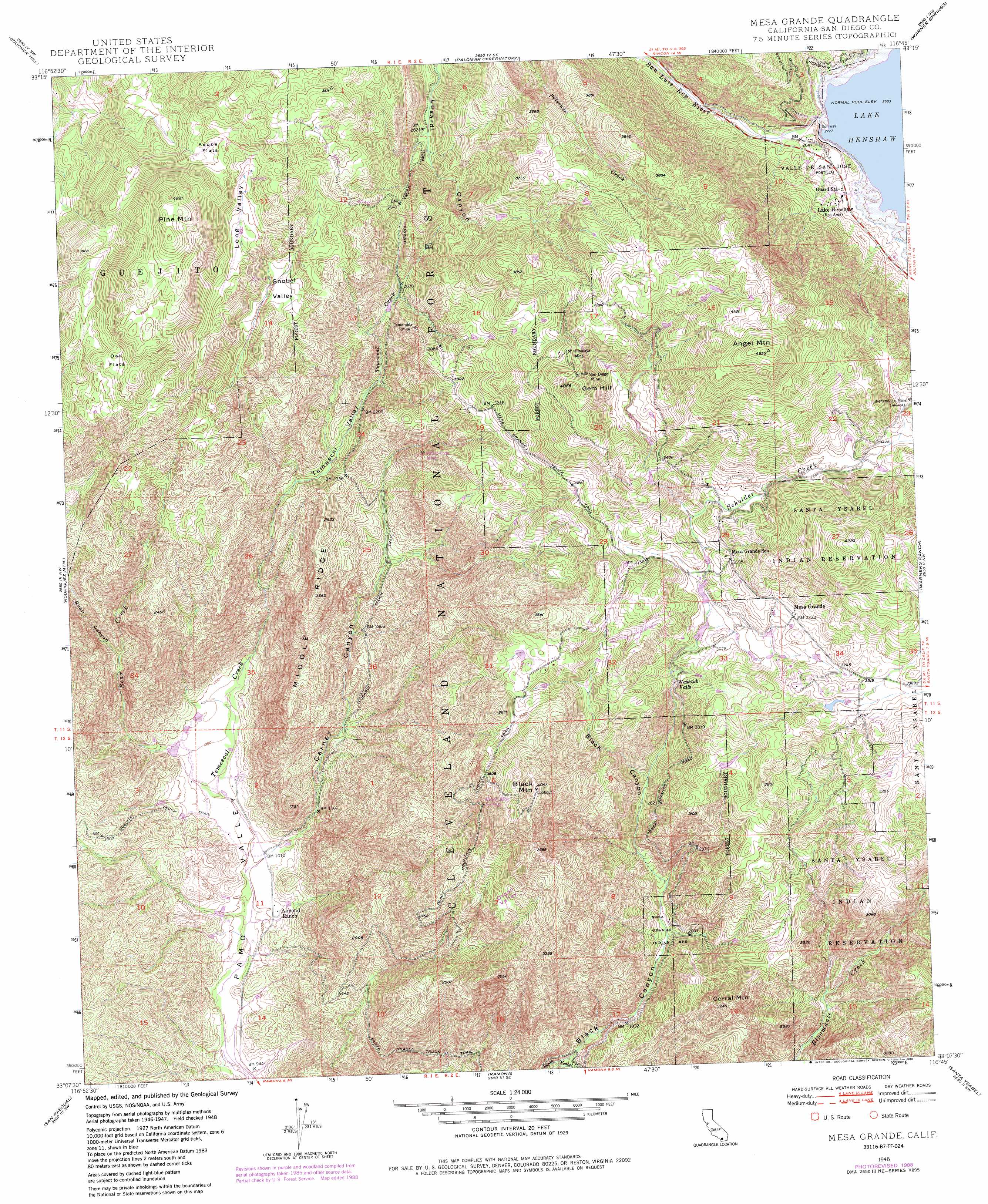
Mesa Grande Topo Map California
To zoom in, hover over the map of Mesa Grande
USGS Topo Quad 33116b7 - 1:24,000 scale
| Topo Map Name: | Mesa Grande |
| USGS Topo Quad ID: | 33116b7 |
| Print Size: | ca. 21 1/4" wide x 27" high |
| Southeast Coordinates: | 33.125° N latitude / 116.75° W longitude |
| Map Center Coordinates: | 33.1875° N latitude / 116.8125° W longitude |
| U.S. State: | CA |
| Filename: | o33116b7.jpg |
| Download Map JPG Image: | Mesa Grande topo map 1:24,000 scale |
| Map Type: | Topographic |
| Topo Series: | 7.5´ |
| Map Scale: | 1:24,000 |
| Source of Map Images: | United States Geological Survey (USGS) |
| Alternate Map Versions: |
Mesa Grande CA 1948, updated 1956 Download PDF Buy paper map Mesa Grande CA 1948, updated 1967 Download PDF Buy paper map Mesa Grande CA 1948, updated 1973 Download PDF Buy paper map Mesa Grande CA 1948, updated 1982 Download PDF Buy paper map Mesa Grande CA 1948, updated 1984 Download PDF Buy paper map Mesa Grande CA 1948, updated 1988 Download PDF Buy paper map Mesa Grande CA 1949, updated 1949 Download PDF Buy paper map Mesa Grande CA 1997, updated 2000 Download PDF Buy paper map Mesa Grande CA 2012 Download PDF Buy paper map Mesa Grande CA 2015 Download PDF Buy paper map |
| FStopo: | US Forest Service topo Mesa Grande is available: Download FStopo PDF Download FStopo TIF |
1:24,000 Topo Quads surrounding Mesa Grande
Pechanga |
Vail Lake |
Aguanga |
Beauty Mountain |
Bucksnort Mountain |
Pala |
Boucher Hill |
Palomar Observatory |
Warner Springs |
Hot Springs Mountain |
Valley Center |
Rodriguez Mountain |
Mesa Grande |
Warners Ranch |
Ranchita |
Escondido |
San Pasqual |
Ramona |
Santa Ysabel |
Julian |
Poway |
San Vicente Reservoir |
El Cajon Mountain |
Tule Springs |
Cuyamaca Peak |
> Back to 33116a1 at 1:100,000 scale
> Back to 33116a1 at 1:250,000 scale
> Back to U.S. Topo Maps home
Mesa Grande topo map: Gazetteer
Mesa Grande: Airports
Loma Madera Ranch Airport elevation 1017m 3336′Mesa Grande: Basins
Organ Valley elevation 938m 3077′Mesa Grande: Dams
Henshaw 69-002 Dam elevation 830m 2723′Mesa Grande: Falls
Washtub Falls elevation 892m 2926′Mesa Grande: Flats
Adobe Flats elevation 1090m 3576′Oak Flats elevation 1120m 3674′
Mesa Grande: Mines
Esmeralda Mine elevation 914m 2998′Himalaya Mine elevation 1162m 3812′
Patton Lode Mine elevation 814m 2670′
Rose Quartz Mine elevation 823m 2700′
San Diego Mine elevation 1166m 3825′
Shenandoah Mine elevation 1059m 3474′
Mesa Grande: Parks
Lake Henshaw elevation 844m 2769′Mesa Grande: Populated Places
Mesa Grande elevation 987m 3238′Mesa Grande: Reservoirs
Lake Henshaw elevation 830m 2723′Mesa Grande: Ridges
Middle Ridge elevation 810m 2657′Mesa Grande: Springs
Black Mountain Spring elevation 971m 3185′Mesa Grande: Streams
Bear Creek elevation 311m 1020′Scholder Creek elevation 944m 3097′
Mesa Grande: Summits
Angel Mountain elevation 1385m 4543′Black Butte elevation 816m 2677′
Black Mountain elevation 1214m 3982′
Corral Mountain elevation 987m 3238′
Gem Hill elevation 1230m 4035′
Pine Mountain elevation 1284m 4212′
Mesa Grande: Trails
Black Mountain Truck Trail elevation 968m 3175′Guejito Truck Trail elevation 443m 1453′
Lusardi Truck Trail elevation 918m 3011′
Mesa Grande Truck Trail elevation 1015m 3330′
Mesa Grande: Valleys
Black Canyon elevation 503m 1650′Carney Canyon elevation 312m 1023′
Long Valley elevation 1024m 3359′
Quail Canyon elevation 486m 1594′
Snobel Valley elevation 915m 3001′
Temescal Valley elevation 667m 2188′
Mesa Grande digital topo map on disk
Buy this Mesa Grande topo map showing relief, roads, GPS coordinates and other geographical features, as a high-resolution digital map file on DVD: