Warner Springs Topo Map California
To zoom in, hover over the map of Warner Springs
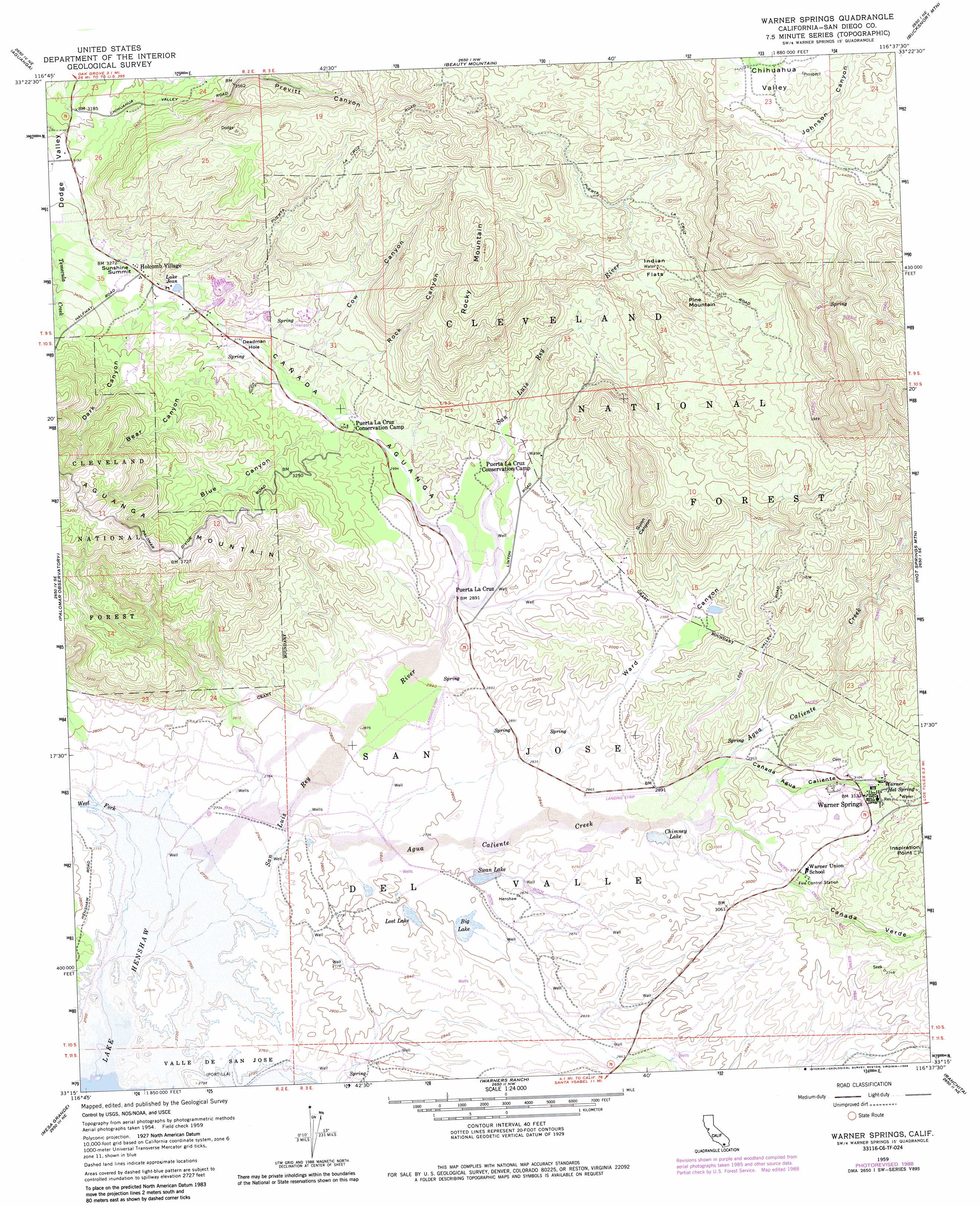
USGS Topo Quad 33116c6 - 1:24,000 scale
| Topo Map Name: | Warner Springs |
| USGS Topo Quad ID: | 33116c6 |
| Print Size: | ca. 21 1/4" wide x 27" high |
| Southeast Coordinates: | 33.25° N latitude / 116.625° W longitude |
| Map Center Coordinates: | 33.3125° N latitude / 116.6875° W longitude |
| U.S. State: | CA |
| Filename: | o33116c6.jpg |
| Download Map JPG Image: | Warner Springs topo map 1:24,000 scale |
| Map Type: | Topographic |
| Topo Series: | 7.5´ |
| Map Scale: | 1:24,000 |
| Source of Map Images: | United States Geological Survey (USGS) |
| Alternate Map Versions: |
Warner Springs CA 1958, updated 1988 Download PDF Buy paper map Warner Springs CA 1959, updated 1961 Download PDF Buy paper map Warner Springs CA 1959, updated 1964 Download PDF Buy paper map Warner Springs CA 1959, updated 1982 Download PDF Buy paper map Warner Springs CA 1959, updated 1984 Download PDF Buy paper map Warner Springs CA 2012 Download PDF Buy paper map Warner Springs CA 2015 Download PDF Buy paper map |
| FStopo: | US Forest Service topo Warner Springs is available: Download FStopo PDF Download FStopo TIF |
1:24,000 Topo Quads surrounding Warner Springs
Sage |
Cahuilla Mountain |
Anza |
Butterfly Peak |
Toro Peak |
Vail Lake |
Aguanga |
Beauty Mountain |
Bucksnort Mountain |
Collins Valley |
Boucher Hill |
Palomar Observatory |
Warner Springs |
Hot Springs Mountain |
Borrego Palm Canyon |
Rodriguez Mountain |
Mesa Grande |
Warners Ranch |
Ranchita |
Tubb Canyon |
San Pasqual |
Ramona |
Santa Ysabel |
Julian |
Earthquake Valley |
> Back to 33116a1 at 1:100,000 scale
> Back to 33116a1 at 1:250,000 scale
> Back to U.S. Topo Maps home
Warner Springs topo map: Gazetteer
Warner Springs: Airports
Warner Springs Gliderport elevation 875m 2870′Warner Springs: Flats
Indian Flats elevation 1097m 3599′Warner Springs: Gaps
Sunshine Summit elevation 1004m 3293′Warner Springs: Lakes
Big Lake elevation 852m 2795′Chimney Lake elevation 878m 2880′
Lake Jean elevation 992m 3254′
Lost Lake elevation 846m 2775′
Swan Lake elevation 853m 2798′
Warner Springs: Populated Places
Holcomb Village elevation 1002m 3287′Warner Springs elevation 954m 3129′
Warner Springs: Springs
Warner Hot Spring elevation 956m 3136′Warner Springs: Streams
Agua Caliente Creek elevation 841m 2759′West Fork San Luis Rey River elevation 822m 2696′
Warner Springs: Summits
Pine Mountain elevation 1176m 3858′Rocky Mountain elevation 1343m 4406′
Warner Springs: Valleys
Bear Canyon elevation 931m 3054′Blue Canyon elevation 922m 3024′
Cañada Agua Caliente elevation 892m 2926′
Cañada Aguanga elevation 889m 2916′
Cañada Verde elevation 885m 2903′
Cow Canyon elevation 925m 3034′
Dark Canyon elevation 977m 3205′
Deadman Hole elevation 941m 3087′
Gunn Canyon elevation 934m 3064′
Johnson Canyon elevation 1317m 4320′
Rock Canyon elevation 922m 3024′
Ward Canyon elevation 870m 2854′
Warner Springs digital topo map on disk
Buy this Warner Springs topo map showing relief, roads, GPS coordinates and other geographical features, as a high-resolution digital map file on DVD: