Palm View Peak Topo Map California
To zoom in, hover over the map of Palm View Peak
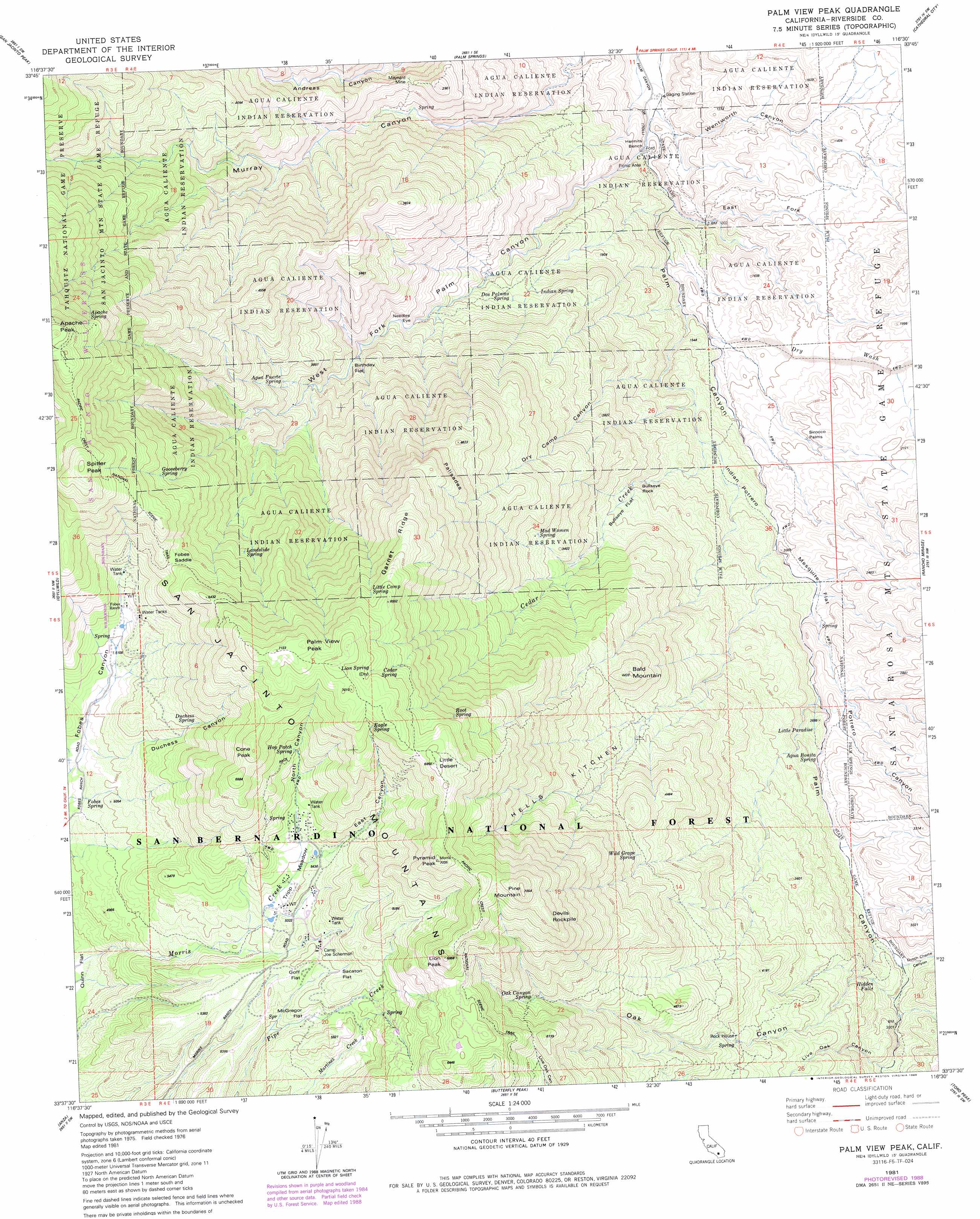
USGS Topo Quad 33116f5 - 1:24,000 scale
| Topo Map Name: | Palm View Peak |
| USGS Topo Quad ID: | 33116f5 |
| Print Size: | ca. 21 1/4" wide x 27" high |
| Southeast Coordinates: | 33.625° N latitude / 116.5° W longitude |
| Map Center Coordinates: | 33.6875° N latitude / 116.5625° W longitude |
| U.S. State: | CA |
| Filename: | o33116f5.jpg |
| Download Map JPG Image: | Palm View Peak topo map 1:24,000 scale |
| Map Type: | Topographic |
| Topo Series: | 7.5´ |
| Map Scale: | 1:24,000 |
| Source of Map Images: | United States Geological Survey (USGS) |
| Alternate Map Versions: |
Palm View Peak CA 1981, updated 1982 Download PDF Buy paper map Palm View Peak CA 1981, updated 1986 Download PDF Buy paper map Palm View Peak CA 1981, updated 1988 Download PDF Buy paper map Palm View Peak CA 1996, updated 1999 Download PDF Buy paper map Palm View Peak CA 2012 Download PDF Buy paper map Palm View Peak CA 2015 Download PDF Buy paper map |
| FStopo: | US Forest Service topo Palm View Peak is available: Download FStopo PDF Download FStopo TIF |
1:24,000 Topo Quads surrounding Palm View Peak
Cabazon |
White Water |
Desert Hot Springs |
Seven Palms Valley |
East Deception Canyon |
Lake Fulmor |
San Jacinto Peak |
Palm Springs |
Cathedral City |
Myoma |
Blackburn Canyon |
Idyllwild |
Palm View Peak |
Rancho Mirage |
La Quinta |
Cahuilla Mountain |
Anza |
Butterfly Peak |
Toro Peak |
Martinez Mountain |
Aguanga |
Beauty Mountain |
Bucksnort Mountain |
Collins Valley |
Clark Lake Ne |
> Back to 33116e1 at 1:100,000 scale
> Back to 33116a1 at 1:250,000 scale
> Back to U.S. Topo Maps home
Palm View Peak topo map: Gazetteer
Palm View Peak: Benches
Hermits Bench elevation 249m 816′Palm View Peak: Falls
Hidden Falls elevation 962m 3156′Palm View Peak: Flats
Birthday Flat elevation 927m 3041′Bullseye Flat elevation 779m 2555′
Goff Flat elevation 1638m 5374′
Hells Kitchen elevation 1558m 5111′
Indian Potrero elevation 583m 1912′
McGregor Flat elevation 1653m 5423′
Mesquite Flat elevation 664m 2178′
Needles Eye elevation 790m 2591′
Sacaton Flat elevation 1645m 5396′
Tripp Meadow elevation 1636m 5367′
Palm View Peak: Gaps
Fobes Saddle elevation 1827m 5994′Palm View Peak: Mines
Maynard Mine elevation 778m 2552′Palm View Peak: Pillars
Bulls Eye Rock elevation 734m 2408′Palm View Peak: Plains
Little Desert elevation 1866m 6122′Palm View Peak: Ridges
Garnet Ridge elevation 1930m 6332′Palm View Peak: Springs
Agua Bonita Spring elevation 822m 2696′Agua Fuerte Spring elevation 1163m 3815′
Apache Spring elevation 2089m 6853′
Cedar Spring elevation 1982m 6502′
Dos Palmas Spring elevation 695m 2280′
Duchess Spring elevation 1680m 5511′
Eagle Spring elevation 2071m 6794′
Fobes Spring elevation 1500m 4921′
Gooseberry Spring elevation 1782m 5846′
Hop Patch Spring elevation 1778m 5833′
Indian Spring elevation 695m 2280′
Landslide Spring elevation 1618m 5308′
Lion Spring elevation 2059m 6755′
Little Camp Spring elevation 1913m 6276′
Little Paradise elevation 860m 2821′
Mad Woman Spring elevation 1081m 3546′
Oak Canyon Spring elevation 1669m 5475′
Root Spring elevation 1911m 6269′
Wild Grape Spring elevation 1389m 4557′
Palm View Peak: Streams
Cedar Creek elevation 397m 1302′Dry Wash elevation 439m 1440′
Palm View Peak: Summits
Bald Mountain elevation 1344m 4409′Cone Peak elevation 2077m 6814′
Devils Rockpile elevation 1870m 6135′
Lion Peak elevation 2089m 6853′
Palm View Peak elevation 2184m 7165′
Pine Mountain elevation 2147m 7043′
Pyramid Peak elevation 2138m 7014′
Spitler Peak elevation 2247m 7372′
Palm View Peak: Trails
Desert Divide Trail elevation 2114m 6935′Palm View Peak: Valleys
Dry Camp Canyon elevation 485m 1591′Duchess Canyon elevation 1498m 4914′
Dutch Charlie Canyon elevation 899m 2949′
East Fork Palm Canyon elevation 258m 846′
Live Oak Canyon elevation 954m 3129′
Oak Canyon elevation 904m 2965′
Potrero Canyon elevation 634m 2080′
Rock Canyon elevation 446m 1463′
Wentworth Canyon elevation 220m 721′
West Fork Palm Canyon elevation 220m 721′
Palm View Peak: Woods
Sirocco Palms elevation 535m 1755′Palm View Peak digital topo map on disk
Buy this Palm View Peak topo map showing relief, roads, GPS coordinates and other geographical features, as a high-resolution digital map file on DVD: