Desert Hot Springs Topo Map California
To zoom in, hover over the map of Desert Hot Springs
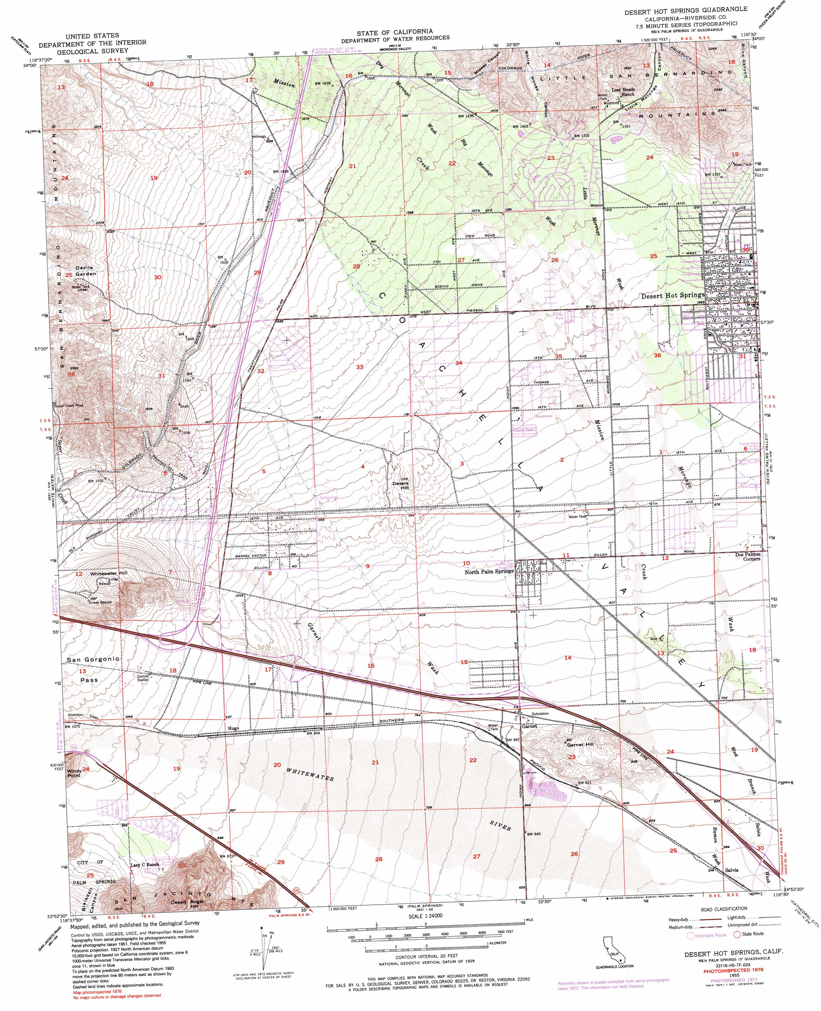
USGS Topo Quad 33116h5 - 1:24,000 scale
| Topo Map Name: | Desert Hot Springs |
| USGS Topo Quad ID: | 33116h5 |
| Print Size: | ca. 21 1/4" wide x 27" high |
| Southeast Coordinates: | 33.875° N latitude / 116.5° W longitude |
| Map Center Coordinates: | 33.9375° N latitude / 116.5625° W longitude |
| U.S. State: | CA |
| Filename: | o33116h5.jpg |
| Download Map JPG Image: | Desert Hot Springs topo map 1:24,000 scale |
| Map Type: | Topographic |
| Topo Series: | 7.5´ |
| Map Scale: | 1:24,000 |
| Source of Map Images: | United States Geological Survey (USGS) |
| Alternate Map Versions: |
Desert Hot Springs CA 1955, updated 1956 Download PDF Buy paper map Desert Hot Springs CA 1955, updated 1961 Download PDF Buy paper map Desert Hot Springs CA 1955, updated 1973 Download PDF Buy paper map Desert Hot Springs CA 1955, updated 1987 Download PDF Buy paper map Desert Hot Springs CA 2012 Download PDF Buy paper map Desert Hot Springs CA 2015 Download PDF Buy paper map |
| FStopo: | US Forest Service topo Desert Hot Springs is available: Download FStopo PDF Download FStopo TIF |
1:24,000 Topo Quads surrounding Desert Hot Springs
Moonridge |
Onyx Peak |
Rimrock |
Yucca Valley North |
Joshua Tree North |
San Gorgonio Mountain |
Catclaw Flat |
Morongo Valley |
Yucca Valley South |
Joshua Tree South |
Cabazon |
White Water |
Desert Hot Springs |
Seven Palms Valley |
East Deception Canyon |
Lake Fulmor |
San Jacinto Peak |
Palm Springs |
Cathedral City |
Myoma |
Blackburn Canyon |
Idyllwild |
Palm View Peak |
Rancho Mirage |
La Quinta |
> Back to 33116e1 at 1:100,000 scale
> Back to 33116a1 at 1:250,000 scale
> Back to U.S. Topo Maps home
Desert Hot Springs topo map: Gazetteer
Desert Hot Springs: Airports
Devers Substation Heliport elevation 349m 1145′Desert Hot Springs: Flats
Devils Garden elevation 652m 2139′Desert Hot Springs: Parks
Arroyo Park elevation 309m 1013′Wardman Park elevation 366m 1200′
Desert Hot Springs: Populated Places
Carefree Mobile Village elevation 269m 882′Desert Hot Springs elevation 328m 1076′
Dos Palmas Corners elevation 252m 826′
Garnet elevation 217m 711′
North Palm Springs elevation 263m 862′
Desert Hot Springs: Post Offices
Desert Hot Springs Post Office elevation 327m 1072′North Palm Springs Post Office elevation 268m 879′
Desert Hot Springs: Streams
Big Morongo Wash elevation 334m 1095′Dry Morongo Wash elevation 424m 1391′
Garnet Wash elevation 211m 692′
Little Morongo Creek elevation 415m 1361′
Little Morongo Wash elevation 334m 1095′
Mission Creek elevation 177m 580′
Super Creek elevation 442m 1450′
Desert Hot Springs: Summits
Desert Angel elevation 702m 2303′Devers Hill elevation 357m 1171′
Garnet Hill elevation 267m 875′
Whitewater Hill elevation 531m 1742′
Desert Hot Springs: Trails
Painted Hill Trail elevation 416m 1364′Desert Hot Springs: Valleys
Blaisdell Canyon elevation 302m 990′Blind Canyon elevation 438m 1437′
Little Morongo Canyon elevation 415m 1361′
Midway Canyon elevation 455m 1492′
White House Canyon elevation 425m 1394′
Desert Hot Springs digital topo map on disk
Buy this Desert Hot Springs topo map showing relief, roads, GPS coordinates and other geographical features, as a high-resolution digital map file on DVD: