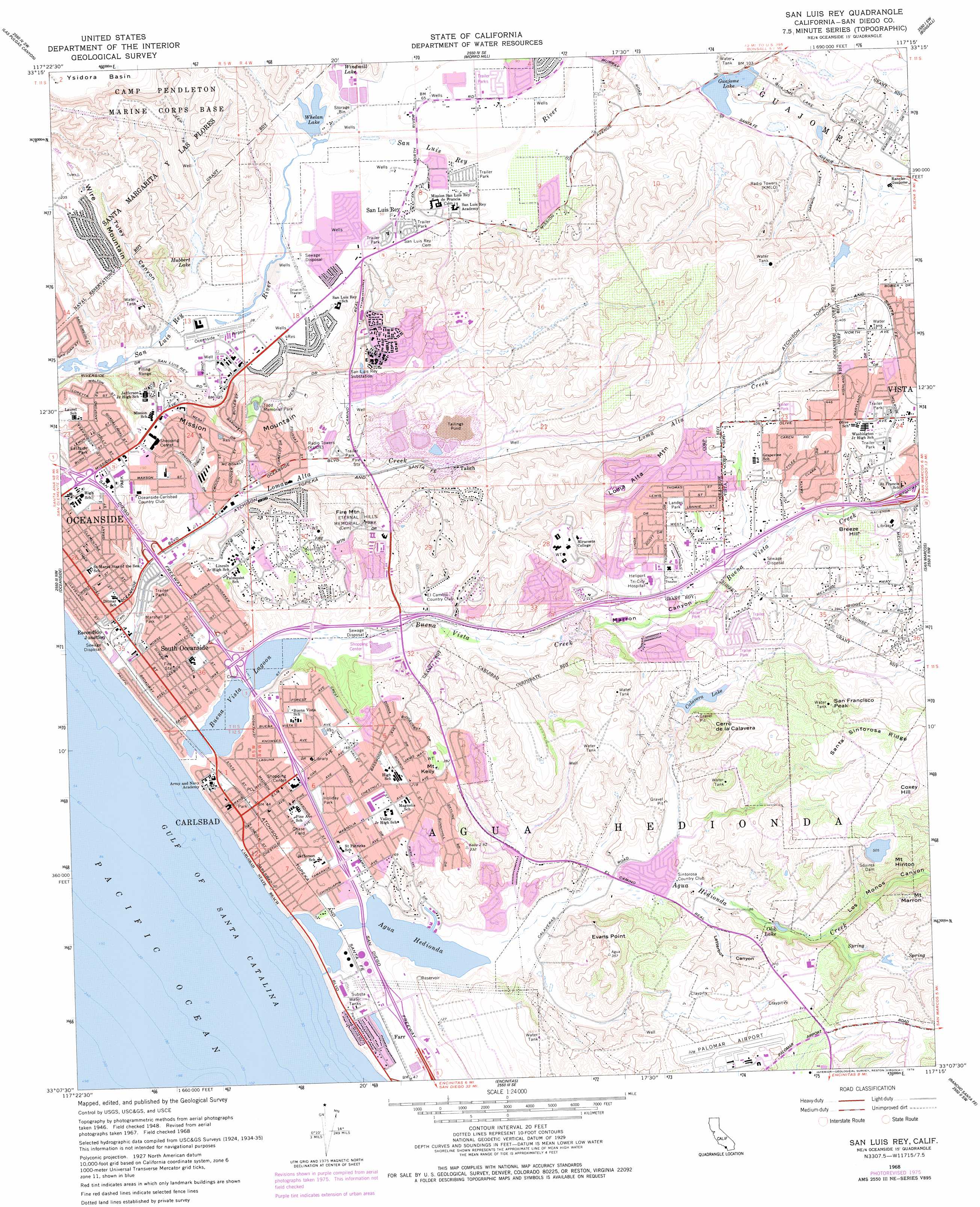
San Luis Rey Topo Map California
To zoom in, hover over the map of San Luis Rey
USGS Topo Quad 33117b3 - 1:24,000 scale
| Topo Map Name: | San Luis Rey |
| USGS Topo Quad ID: | 33117b3 |
| Print Size: | ca. 21 1/4" wide x 27" high |
| Southeast Coordinates: | 33.125° N latitude / 117.25° W longitude |
| Map Center Coordinates: | 33.1875° N latitude / 117.3125° W longitude |
| U.S. State: | CA |
| Filename: | o33117b3.jpg |
| Download Map JPG Image: | San Luis Rey topo map 1:24,000 scale |
| Map Type: | Topographic |
| Topo Series: | 7.5´ |
| Map Scale: | 1:24,000 |
| Source of Map Images: | United States Geological Survey (USGS) |
| Alternate Map Versions: |
San Luis Rey CA 1948, updated 1955 Download PDF Buy paper map San Luis Rey CA 1948, updated 1961 Download PDF Buy paper map San Luis Rey CA 1948, updated 1966 Download PDF Buy paper map San Luis Rey CA 1949 Download PDF Buy paper map San Luis Rey CA 1968, updated 1969 Download PDF Buy paper map San Luis Rey CA 1968, updated 1978 Download PDF Buy paper map San Luis Rey CA 1968, updated 1978 Download PDF Buy paper map San Luis Rey CA 1997, updated 2000 Download PDF Buy paper map San Luis Rey CA 2012 Download PDF Buy paper map San Luis Rey CA 2015 Download PDF Buy paper map |
1:24,000 Topo Quads surrounding San Luis Rey
San Clemente |
Margarita Peak |
Fallbrook |
Temecula |
Pechanga |
San Onofre Bluff |
Las Pulgas Canyon |
Morro Hill |
Bonsall |
Pala |
Oceanside |
San Luis Rey |
San Marcos |
Valley Center |
|
Encinitas |
Rancho Santa Fe |
Escondido |
||
Del Mar |
Poway |
> Back to 33117a1 at 1:100,000 scale
> Back to 33116a1 at 1:250,000 scale
> Back to U.S. Topo Maps home
San Luis Rey topo map: Gazetteer
San Luis Rey: Airports
McClellan-Palomar Airport elevation 96m 314′Oceanside Municipal Airport elevation 9m 29′
Tri-City Hospital Heliport elevation 76m 249′
San Luis Rey: Areas
Tacayme elevation 30m 98′San Luis Rey: Bays
Agua Hedionda elevation 0m 0′San Luis Rey: Beaches
Saint Malo Beach elevation 4m 13′South Oceanside Beach elevation 5m 16′
San Luis Rey: Crossings
Interchange 48 elevation 19m 62′Interchange 49 elevation 19m 62′
Interchange 50 elevation 25m 82′
Interchange 51A elevation 19m 62′
Interchange 51B elevation 16m 52′
Interchange 52 elevation 7m 22′
Interchange 53 elevation 37m 121′
San Luis Rey: Dams
Calavera 847 Dam elevation 63m 206′Squires Dam elevation 154m 505′
San Luis Rey: Lakes
Buena Vista Lagoon elevation 0m 0′Oak Lake elevation 30m 98′
San Luis Rey: Parks
Alamosa Park elevation 43m 141′Breeze Hill Park elevation 106m 347′
Bub Williamson Park elevation 98m 321′
Buccaneer Beach Park elevation 5m 16′
Calavera Park elevation 80m 262′
Canyon Park elevation 16m 52′
Car Country Park elevation 19m 62′
Carlsbad State Beach elevation 9m 29′
Cedar Lane City Park elevation 104m 341′
Chase Field elevation 20m 65′
Community Center Park elevation 22m 72′
Eastside Park elevation 43m 141′
Encino Public Fishing Area elevation 4m 13′
Fire Mountain Park elevation 89m 291′
Fireside Park elevation 12m 39′
Guajome Park elevation 51m 167′
Heritage Village Park elevation 31m 101′
Holiday Park elevation 26m 85′
Ivey Ranch Park elevation 23m 75′
Laguna Riviera City Park elevation 9m 29′
Landes Park elevation 106m 347′
Lions Club Park elevation 12m 39′
Magee Park elevation 16m 52′
Marshall Street Park elevation 13m 42′
Maxton Brown Park elevation 11m 36′
Oak Riparian Park elevation 83m 272′
Rancho del Oro Community Park elevation 48m 157′
Rotary Park elevation 14m 45′
Sherbourne Park elevation 123m 403′
Skylark Park elevation 40m 131′
South Oceanside Park elevation 19m 62′
Todd Memorial Park elevation 86m 282′
San Luis Rey: Populated Places
Carlsbad elevation 16m 52′Carlsbad Trailer Park elevation 16m 52′
El Camino 76 Trailer Park elevation 15m 49′
Escondido Junction elevation 12m 39′
Farr elevation 15m 49′
Green Valley Mobile Home Park elevation 67m 219′
Laguna Vista Trailer Park elevation 15m 49′
Mountain View Mobile Estates elevation 103m 337′
Ocean Hills elevation 155m 508′
Oceana elevation 52m 170′
Rancho Calevero Mobile Home Park elevation 99m 324′
Rancho Carlsbad Trailer Park elevation 15m 49′
Rancho San Luis Rey Trailer Park elevation 15m 49′
San Luis Rey elevation 18m 59′
South Oceanside elevation 18m 59′
Talich elevation 45m 147′
The Palms Trailer Park elevation 99m 324′
Tiki Mobile Village elevation 124m 406′
Trico Mobile Estates elevation 16m 52′
San Luis Rey: Post Offices
Carlsbad Post Office elevation 14m 45′San Luis Rey: Reservoirs
Calavera Lake elevation 63m 206′Guajome Lake elevation 29m 95′
Hubbert Lake elevation 11m 36′
Whelan Lake elevation 16m 52′
Windmill Lake elevation 16m 52′
San Luis Rey: Ridges
Mission Mountain elevation 70m 229′Santa Sinforosa Ridge elevation 158m 518′
San Luis Rey: Streams
Agua Hedionda Creek elevation 6m 19′Buena Vista Creek elevation 0m 0′
Loma Alta Creek elevation 6m 19′
Pilgrim Creek elevation 14m 45′
San Luis Rey: Summits
Breeze Hill elevation 117m 383′Cerro de la Calavera elevation 154m 505′
Coxey Hill elevation 171m 561′
Evans Point elevation 107m 351′
Fire Mountain elevation 93m 305′
Loma Alta Mountain elevation 146m 479′
Mount Hinton elevation 177m 580′
Mount Kelly elevation 105m 344′
Mount Marron elevation 167m 547′
San Francisco Peak elevation 154m 505′
Wire Mountain elevation 94m 308′
San Luis Rey: Swamps
Loma Alta Marsh elevation 6m 19′San Luis Rey: Valleys
Letterbox Canyon elevation 24m 78′Los Monos Canyon elevation 37m 121′
Marron Canyon elevation 44m 144′
Tuley Canyon elevation 10m 32′
Windmill Canyon elevation 17m 55′
San Luis Rey: Wells
Fraziers Mineral Well elevation 15m 49′San Luis Rey digital topo map on disk
Buy this San Luis Rey topo map showing relief, roads, GPS coordinates and other geographical features, as a high-resolution digital map file on DVD: