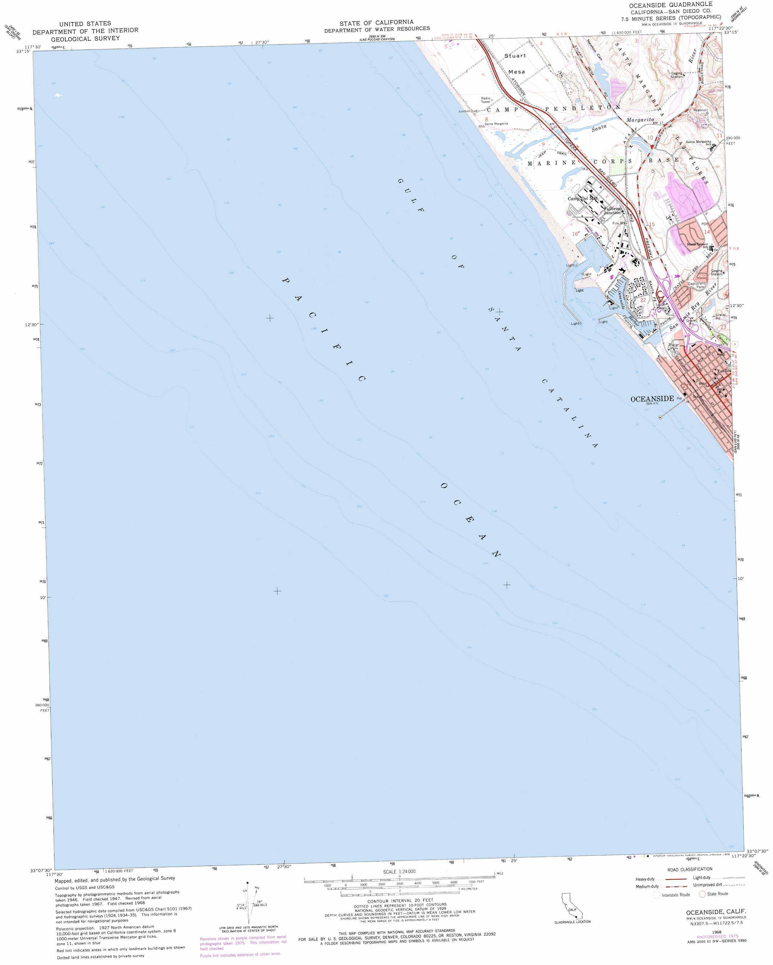
Oceanside Topo Map California
To zoom in, hover over the map of Oceanside
USGS Topo Quad 33117b4 - 1:24,000 scale
| Topo Map Name: | Oceanside |
| USGS Topo Quad ID: | 33117b4 |
| Print Size: | ca. 21 1/4" wide x 27" high |
| Southeast Coordinates: | 33.125° N latitude / 117.375° W longitude |
| Map Center Coordinates: | 33.1875° N latitude / 117.4375° W longitude |
| U.S. State: | CA |
| Filename: | o33117b4.jpg |
| Download Map JPG Image: | Oceanside topo map 1:24,000 scale |
| Map Type: | Topographic |
| Topo Series: | 7.5´ |
| Map Scale: | 1:24,000 |
| Source of Map Images: | United States Geological Survey (USGS) |
| Alternate Map Versions: |
Oceanside CA 1947, updated 1957 Download PDF Buy paper map Oceanside CA 1947, updated 1962 Download PDF Buy paper map Oceanside CA 1949, updated 1949 Download PDF Buy paper map Oceanside CA 1968, updated 1970 Download PDF Buy paper map Oceanside CA 1968, updated 1978 Download PDF Buy paper map Oceanside CA 1997, updated 2000 Download PDF Buy paper map Oceanside CA 2012 Download PDF Buy paper map Oceanside CA 2015 Download PDF Buy paper map |
1:24,000 Topo Quads surrounding Oceanside
Dana Point |
San Clemente |
Margarita Peak |
Fallbrook |
Temecula |
San Onofre Bluff |
Las Pulgas Canyon |
Morro Hill |
Bonsall |
|
Oceanside |
San Luis Rey |
San Marcos |
||
Encinitas |
Rancho Santa Fe |
|||
Del Mar |
> Back to 33117a1 at 1:100,000 scale
> Back to 33116a1 at 1:250,000 scale
> Back to U.S. Topo Maps home
Oceanside topo map: Gazetteer
Oceanside: Basins
Del Mar Boat Basin elevation 0m 0′Oceanside: Beaches
Harbor Beach elevation 6m 19′Oceanside City Beach elevation 7m 22′
Oceanside: Crossings
Interchange 54A elevation 34m 111′Interchange 54B elevation 3m 9′
Interchange 54C elevation 19m 62′
Oceanside: Harbors
Camp Pendleton Boat Basin elevation -3m -10′North Harbor elevation 2m 6′
Oceanside Harbor elevation 0m 0′
South Harbor elevation 4m 13′
Oceanside: Parks
Capistrano Park elevation 6m 19′Pacific Street Linear Park elevation 9m 29′
Rotary Park elevation 9m 29′
Tyson Street Park elevation 7m 22′
Oceanside: Populated Places
Fallbrook Junction elevation 19m 62′Oceanside elevation 20m 65′
Yaldora elevation 8m 26′
Oceanside: Post Offices
Oceanside Post Office elevation 21m 68′Oceanside: Streams
San Luis Rey River elevation 1m 3′Santa Margarita River elevation 2m 6′
Oceanside: Summits
Stuart Mesa elevation 40m 131′Oceanside: Swamps
Santa Margarita Marsh elevation 2m 6′Oceanside: Valleys
Lawrence Canyon elevation 4m 13′Newton Canyon elevation 4m 13′
Oceanside digital topo map on disk
Buy this Oceanside topo map showing relief, roads, GPS coordinates and other geographical features, as a high-resolution digital map file on DVD: