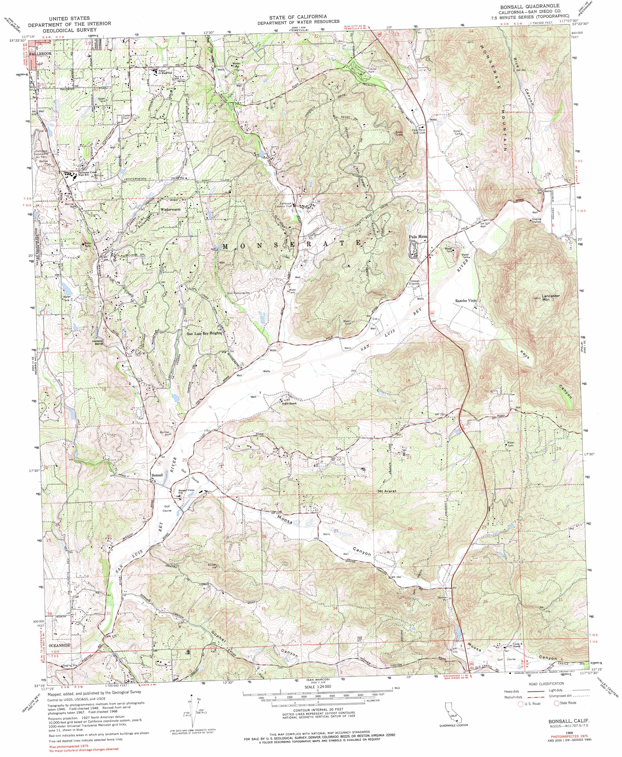
Bonsall Topo Map California
To zoom in, hover over the map of Bonsall
USGS Topo Quad 33117c2 - 1:24,000 scale
| Topo Map Name: | Bonsall |
| USGS Topo Quad ID: | 33117c2 |
| Print Size: | ca. 21 1/4" wide x 27" high |
| Southeast Coordinates: | 33.25° N latitude / 117.125° W longitude |
| Map Center Coordinates: | 33.3125° N latitude / 117.1875° W longitude |
| U.S. State: | CA |
| Filename: | o33117c2.jpg |
| Download Map JPG Image: | Bonsall topo map 1:24,000 scale |
| Map Type: | Topographic |
| Topo Series: | 7.5´ |
| Map Scale: | 1:24,000 |
| Source of Map Images: | United States Geological Survey (USGS) |
| Alternate Map Versions: |
Bonsall CA 1948, updated 1956 Download PDF Buy paper map Bonsall CA 1948, updated 1963 Download PDF Buy paper map Bonsall CA 1949 Download PDF Buy paper map Bonsall CA 1968, updated 1970 Download PDF Buy paper map Bonsall CA 1968, updated 1970 Download PDF Buy paper map Bonsall CA 1968, updated 1977 Download PDF Buy paper map Bonsall CA 2012 Download PDF Buy paper map Bonsall CA 2015 Download PDF Buy paper map |
1:24,000 Topo Quads surrounding Bonsall
Sitton Peak |
Wildomar |
Murrieta |
Bachelor Mountain |
Sage |
Margarita Peak |
Fallbrook |
Temecula |
Pechanga |
Vail Lake |
Las Pulgas Canyon |
Morro Hill |
Bonsall |
Pala |
Boucher Hill |
Oceanside |
San Luis Rey |
San Marcos |
Valley Center |
Rodriguez Mountain |
Encinitas |
Rancho Santa Fe |
Escondido |
San Pasqual |
> Back to 33117a1 at 1:100,000 scale
> Back to 33116a1 at 1:250,000 scale
> Back to U.S. Topo Maps home
Bonsall topo map: Gazetteer
Bonsall: Bends
Hellers Bend elevation 87m 285′Bonsall: Bridges
West Lilac Bridge elevation 242m 793′Bonsall: Crossings
Interchange 41 elevation 145m 475′Interchange 43 elevation 176m 577′
Interchange 46 elevation 87m 285′
Bonsall: Parks
Bonsall Preserve elevation 54m 177′Dinwiddie Preserve elevation 176m 577′
Live Oak Park elevation 182m 597′
Los Jilgueros Preserve elevation 182m 597′
Palomares House and Park elevation 182m 597′
Bonsall: Populated Places
Bonsall elevation 55m 180′Pala Mesa elevation 108m 354′
San Luis Rey Heights elevation 114m 374′
Winterwarm elevation 190m 623′
Bonsall: Streams
Adler Creek elevation 63m 206′Keys Creek elevation 64m 209′
Bonsall: Summits
Lancaster Mountain elevation 452m 1482′Monserate Mountain elevation 472m 1548′
Mount Ararat elevation 260m 853′
Bonsall: Valleys
Couser Canyon elevation 89m 291′Gopher Canyon elevation 42m 137′
Keys Canyon elevation 75m 246′
Moosa Canyon elevation 49m 160′
Rice Canyon elevation 90m 295′
South Fork Gopher Canyon elevation 90m 295′
Bonsall digital topo map on disk
Buy this Bonsall topo map showing relief, roads, GPS coordinates and other geographical features, as a high-resolution digital map file on DVD: