Fallbrook Topo Map California
To zoom in, hover over the map of Fallbrook
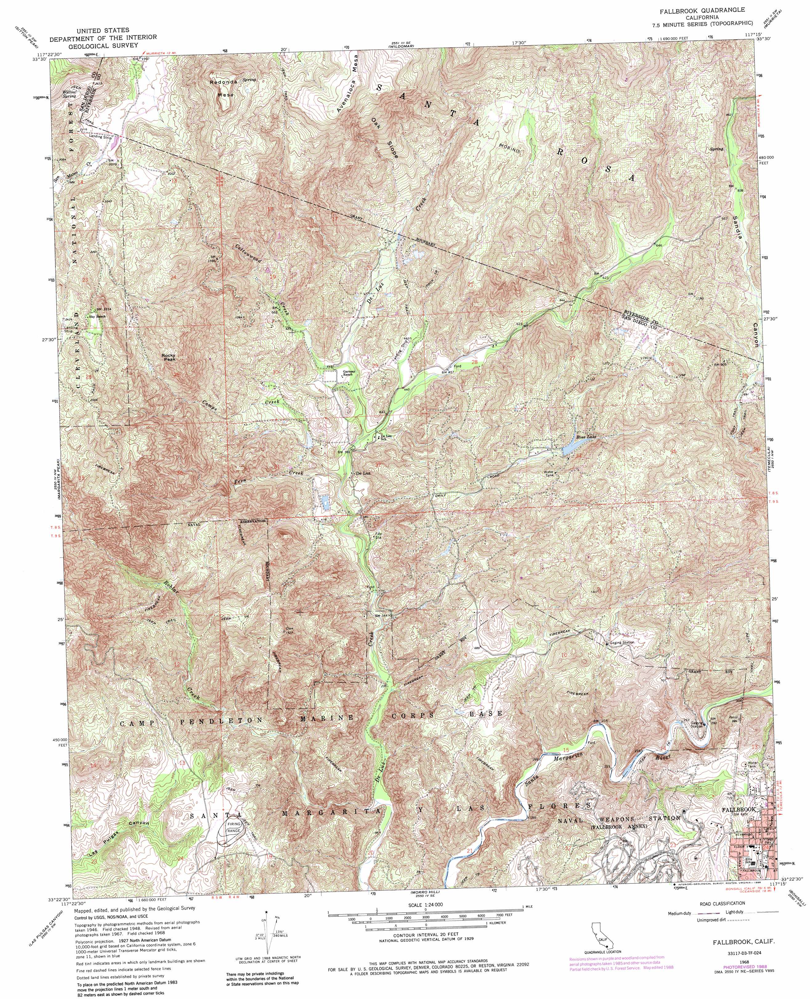
USGS Topo Quad 33117d3 - 1:24,000 scale
| Topo Map Name: | Fallbrook |
| USGS Topo Quad ID: | 33117d3 |
| Print Size: | ca. 21 1/4" wide x 27" high |
| Southeast Coordinates: | 33.375° N latitude / 117.25° W longitude |
| Map Center Coordinates: | 33.4375° N latitude / 117.3125° W longitude |
| U.S. State: | CA |
| Filename: | o33117d3.jpg |
| Download Map JPG Image: | Fallbrook topo map 1:24,000 scale |
| Map Type: | Topographic |
| Topo Series: | 7.5´ |
| Map Scale: | 1:24,000 |
| Source of Map Images: | United States Geological Survey (USGS) |
| Alternate Map Versions: |
Fallbrook CA 1948, updated 1964 Download PDF Buy paper map Fallbrook CA 1949, updated 1949 Download PDF Buy paper map Fallbrook CA 1949, updated 1957 Download PDF Buy paper map Fallbrook CA 1968, updated 1970 Download PDF Buy paper map Fallbrook CA 1968, updated 1982 Download PDF Buy paper map Fallbrook CA 1968, updated 1988 Download PDF Buy paper map Fallbrook CA 1997, updated 2000 Download PDF Buy paper map Fallbrook CA 2012 Download PDF Buy paper map Fallbrook CA 2015 Download PDF Buy paper map |
| FStopo: | US Forest Service topo Fallbrook is available: Download FStopo PDF Download FStopo TIF |
1:24,000 Topo Quads surrounding Fallbrook
Santiago Peak |
Alberhill |
Lake Elsinore |
Romoland |
Winchester |
Canada Gobernadora * |
Sitton Peak |
Wildomar |
Murrieta |
Bachelor Mountain |
San Clemente |
Margarita Peak |
Fallbrook |
Temecula |
Pechanga |
San Onofre Bluff |
Las Pulgas Canyon |
Morro Hill |
Bonsall |
Pala |
Oceanside |
San Luis Rey |
San Marcos |
Valley Center |
> Back to 33117a1 at 1:100,000 scale
> Back to 33116a1 at 1:250,000 scale
> Back to U.S. Topo Maps home
Fallbrook topo map: Gazetteer
Fallbrook: Dams
Matthews 858 Dam elevation 202m 662′Fallbrook: Parks
Village Park elevation 209m 685′Village Square Park elevation 212m 695′
Fallbrook: Populated Places
De Luz elevation 111m 364′De Luz Heights elevation 396m 1299′
Fallbrook elevation 208m 682′
Santa Margarita Groves elevation 405m 1328′
Fallbrook: Post Offices
Fallbrook Post Office elevation 209m 685′Fallbrook: Reservoirs
Ross Lake elevation 264m 866′Fallbrook: Slopes
Oak Slope elevation 481m 1578′Fallbrook: Springs
Willow Spring elevation 718m 2355′Fallbrook: Streams
Camps Creek elevation 117m 383′Cottonwood Creek elevation 134m 439′
Fern Creek elevation 103m 337′
Roblar Creek elevation 57m 187′
Fallbrook: Summits
Avenaloca Mesa elevation 776m 2545′Redonda Mesa elevation 841m 2759′
Rocky Peak elevation 701m 2299′
Fallbrook digital topo map on disk
Buy this Fallbrook topo map showing relief, roads, GPS coordinates and other geographical features, as a high-resolution digital map file on DVD: