Margarita Peak Topo Map California
To zoom in, hover over the map of Margarita Peak
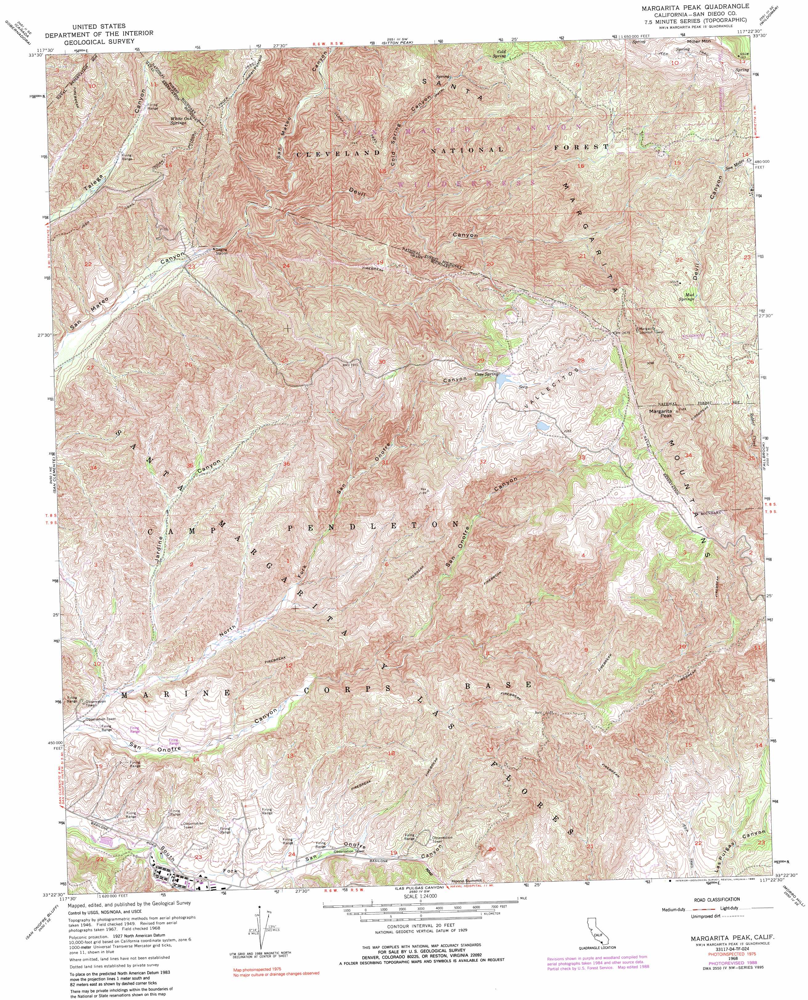
USGS Topo Quad 33117d4 - 1:24,000 scale
| Topo Map Name: | Margarita Peak |
| USGS Topo Quad ID: | 33117d4 |
| Print Size: | ca. 21 1/4" wide x 27" high |
| Southeast Coordinates: | 33.375° N latitude / 117.375° W longitude |
| Map Center Coordinates: | 33.4375° N latitude / 117.4375° W longitude |
| U.S. State: | CA |
| Filename: | o33117d4.jpg |
| Download Map JPG Image: | Margarita Peak topo map 1:24,000 scale |
| Map Type: | Topographic |
| Topo Series: | 7.5´ |
| Map Scale: | 1:24,000 |
| Source of Map Images: | United States Geological Survey (USGS) |
| Alternate Map Versions: |
Margarita Peak CA 1949, updated 1958 Download PDF Buy paper map Margarita Peak CA 1950, updated 1950 Download PDF Buy paper map Margarita Peak CA 1968, updated 1970 Download PDF Buy paper map Margarita Peak CA 1968, updated 1975 Download PDF Buy paper map Margarita Peak CA 1968, updated 1984 Download PDF Buy paper map Margarita Peak CA 1968, updated 1985 Download PDF Buy paper map Margarita Peak CA 1968, updated 1988 Download PDF Buy paper map Margarita Peak CA 1968, updated 1990 Download PDF Buy paper map Margarita Peak CA 1997, updated 2000 Download PDF Buy paper map Margarita Peak CA 2012 Download PDF Buy paper map Margarita Peak CA 2015 Download PDF Buy paper map |
| FStopo: | US Forest Service topo Margarita Peak is available: Download FStopo PDF Download FStopo TIF |
1:24,000 Topo Quads surrounding Margarita Peak
El Toro |
Santiago Peak |
Alberhill |
Lake Elsinore |
Romoland |
San Juan Capistrano |
Canada Gobernadora * |
Sitton Peak |
Wildomar |
Murrieta |
Dana Point |
San Clemente |
Margarita Peak |
Fallbrook |
Temecula |
San Onofre Bluff |
Las Pulgas Canyon |
Morro Hill |
Bonsall |
|
Oceanside |
San Luis Rey |
San Marcos |
> Back to 33117a1 at 1:100,000 scale
> Back to 33116a1 at 1:250,000 scale
> Back to U.S. Topo Maps home
Margarita Peak topo map: Gazetteer
Margarita Peak: Dams
Case Springs Dam elevation 657m 2155′Margarita Peak: Gaps
Horno Summit elevation 245m 803′Margarita Peak: Ranges
Santa Margarita Mountains elevation 618m 2027′Margarita Peak: Reservoirs
Case Springs Lake elevation 657m 2155′Margarita Peak: Springs
Case Spring elevation 664m 2178′Cold Spring elevation 632m 2073′
Mud Springs elevation 667m 2188′
White Oak Springs elevation 389m 1276′
Margarita Peak: Summits
Margarita Peak elevation 956m 3136′Margarita Peak: Trails
Clark Trail elevation 501m 1643′Margarita Peak: Valleys
Cold Spring Canyon elevation 247m 810′Devil Canyon elevation 138m 452′
Jardine Canyon elevation 87m 285′
North Fork San Onofre Canyon elevation 77m 252′
Vallecitos elevation 660m 2165′
Margarita Peak digital topo map on disk
Buy this Margarita Peak topo map showing relief, roads, GPS coordinates and other geographical features, as a high-resolution digital map file on DVD: