Sitton Peak Topo Map California
To zoom in, hover over the map of Sitton Peak
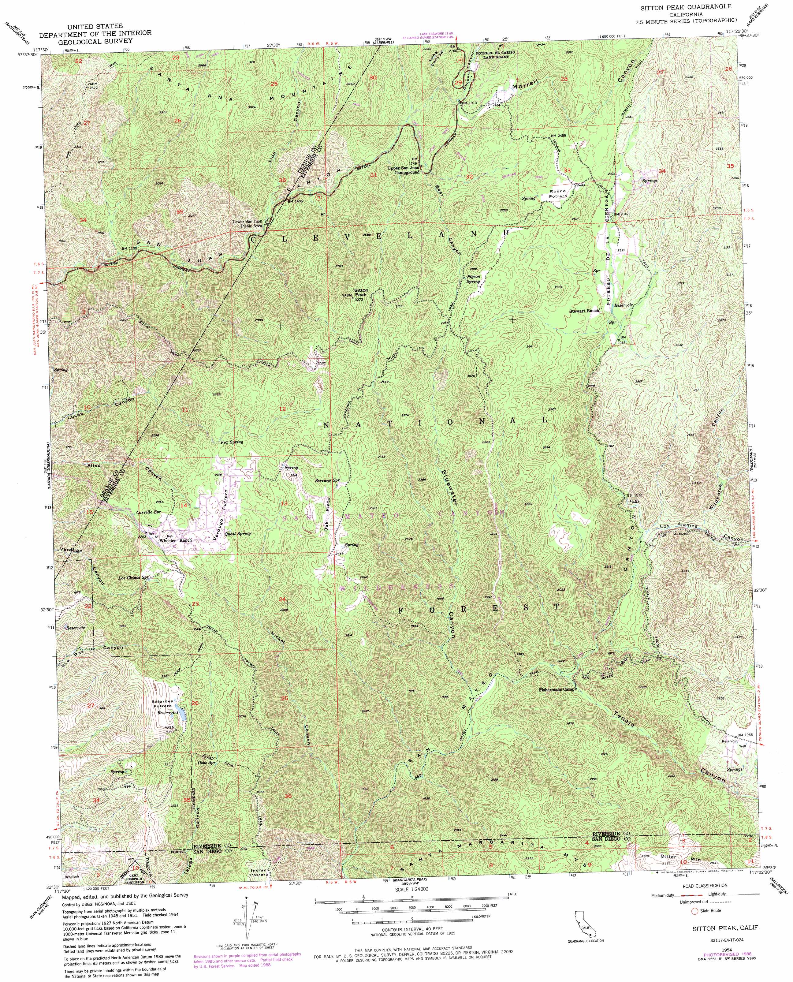
USGS Topo Quad 33117e4 - 1:24,000 scale
| Topo Map Name: | Sitton Peak |
| USGS Topo Quad ID: | 33117e4 |
| Print Size: | ca. 21 1/4" wide x 27" high |
| Southeast Coordinates: | 33.5° N latitude / 117.375° W longitude |
| Map Center Coordinates: | 33.5625° N latitude / 117.4375° W longitude |
| U.S. State: | CA |
| Filename: | o33117e4.jpg |
| Download Map JPG Image: | Sitton Peak topo map 1:24,000 scale |
| Map Type: | Topographic |
| Topo Series: | 7.5´ |
| Map Scale: | 1:24,000 |
| Source of Map Images: | United States Geological Survey (USGS) |
| Alternate Map Versions: |
Sitton Peak CA 1954, updated 1955 Download PDF Buy paper map Sitton Peak CA 1954, updated 1961 Download PDF Buy paper map Sitton Peak CA 1954, updated 1984 Download PDF Buy paper map Sitton Peak CA 1954, updated 1988 Download PDF Buy paper map Sitton Peak CA 1974, updated 1977 Download PDF Buy paper map Sitton Peak CA 1997, updated 2000 Download PDF Buy paper map Sitton Peak CA 2012 Download PDF Buy paper map Sitton Peak CA 2015 Download PDF Buy paper map |
| FStopo: | US Forest Service topo Sitton Peak is available: Download FStopo PDF Download FStopo TIF |
1:24,000 Topo Quads surrounding Sitton Peak
Black Star Canyon |
Corona South |
Lake Mathews |
Steele Peak |
Perris |
El Toro |
Santiago Peak |
Alberhill |
Lake Elsinore |
Romoland |
San Juan Capistrano |
Canada Gobernadora * |
Sitton Peak |
Wildomar |
Murrieta |
Dana Point |
San Clemente |
Margarita Peak |
Fallbrook |
Temecula |
San Onofre Bluff |
Las Pulgas Canyon |
Morro Hill |
Bonsall |
> Back to 33117e1 at 1:100,000 scale
> Back to 33116a1 at 1:250,000 scale
> Back to U.S. Topo Maps home
Sitton Peak topo map: Gazetteer
Sitton Peak: Areas
Belardes Potrero elevation 677m 2221′Sitton Peak: Flats
Indian Potrero elevation 657m 2155′Oak Flats elevation 740m 2427′
Round Potrero elevation 755m 2477′
Verdugo Potrero elevation 708m 2322′
Sitton Peak: Springs
Carrillo Spring elevation 659m 2162′Dobe Spring elevation 509m 1669′
Fox Spring elevation 701m 2299′
Los Chinos Spring elevation 668m 2191′
Pigeon Spring elevation 792m 2598′
Quail Spring elevation 688m 2257′
Serrano Spring elevation 755m 2477′
Sitton Peak: Summits
Miller Mountain elevation 885m 2903′Sitton Peak elevation 983m 3225′
Sitton Peak: Trails
Bluewater Truck Trail elevation 690m 2263′Chiquito Trail elevation 778m 2552′
Clark Trail elevation 518m 1699′
Indian Potrero Truck Trail elevation 690m 2263′
Morgan Trail elevation 808m 2650′
San Juan Trail elevation 700m 2296′
San Mateo Trail elevation 313m 1026′
San Mateo Truck Trail elevation 483m 1584′
Sitton Peak Truck Trail elevation 789m 2588′
Tenaja Truck Trail elevation 496m 1627′
Verdugo Truck Trail elevation 795m 2608′
Sitton Peak: Valleys
Bear Canyon elevation 538m 1765′Bluewater Canyon elevation 305m 1000′
Decker Canyon elevation 592m 1942′
Lion Canyon elevation 404m 1325′
Long Canyon elevation 535m 1755′
Los Alamos Canyon elevation 400m 1312′
Morrell Canyon elevation 515m 1689′
Nickel Canyon elevation 231m 757′
Tenaja Canyon elevation 339m 1112′
Wildhorse Canyon elevation 428m 1404′
Sitton Peak digital topo map on disk
Buy this Sitton Peak topo map showing relief, roads, GPS coordinates and other geographical features, as a high-resolution digital map file on DVD: