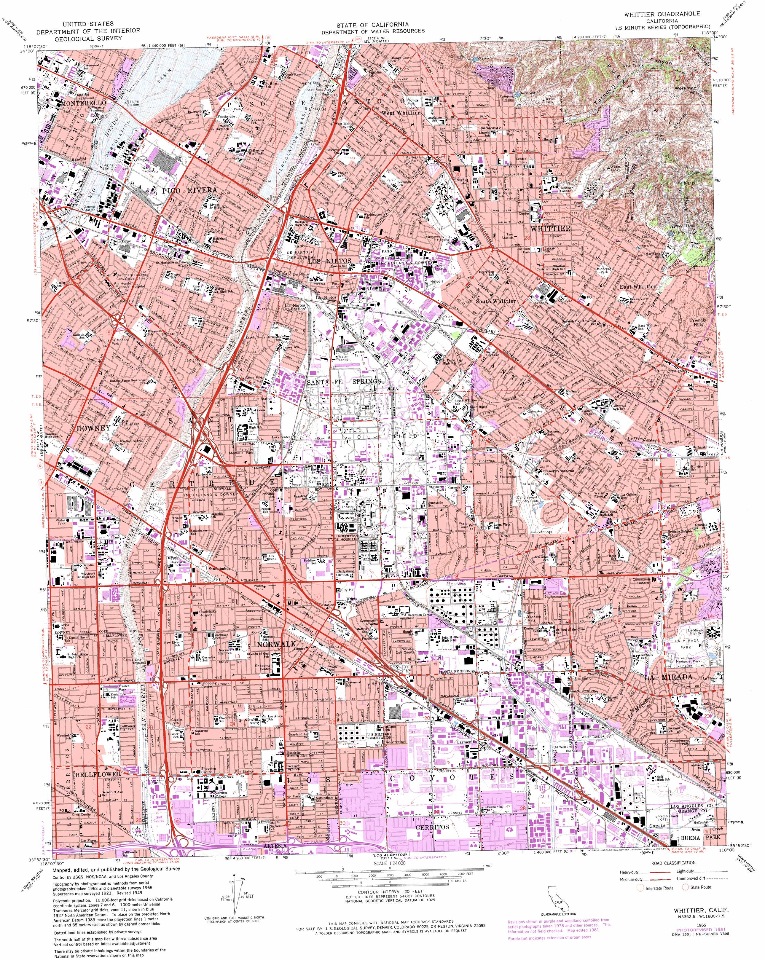
Whittier Topo Map California
To zoom in, hover over the map of Whittier
USGS Topo Quad 33118h1 - 1:24,000 scale
| Topo Map Name: | Whittier |
| USGS Topo Quad ID: | 33118h1 |
| Print Size: | ca. 21 1/4" wide x 27" high |
| Southeast Coordinates: | 33.875° N latitude / 118° W longitude |
| Map Center Coordinates: | 33.9375° N latitude / 118.0625° W longitude |
| U.S. State: | CA |
| Filename: | o33118h1.jpg |
| Download Map JPG Image: | Whittier topo map 1:24,000 scale |
| Map Type: | Topographic |
| Topo Series: | 7.5´ |
| Map Scale: | 1:24,000 |
| Source of Map Images: | United States Geological Survey (USGS) |
| Alternate Map Versions: |
Whittier CA 1949, updated 1955 Download PDF Buy paper map Whittier CA 1951 Download PDF Buy paper map Whittier CA 1965, updated 1967 Download PDF Buy paper map Whittier CA 1965, updated 1975 Download PDF Buy paper map Whittier CA 1965, updated 1982 Download PDF Buy paper map Whittier CA 1965, updated 1984 Download PDF Buy paper map Whittier CA 1965, updated 1984 Download PDF Buy paper map Whittier CA 1974, updated 1975 Download PDF Buy paper map Whittier CA 2012 Download PDF Buy paper map Whittier CA 2015 Download PDF Buy paper map |
1:24,000 Topo Quads surrounding Whittier
Burbank |
Pasadena |
Mount Wilson |
Azusa |
Glendora |
Hollywood |
Los Angeles |
El Monte |
Baldwin Park |
San Dimas |
Inglewood |
South Gate |
Whittier |
La Habra |
Yorba Linda |
Torrance |
Long Beach |
Los Alamitos |
Anaheim |
Orange |
San Pedro |
Seal Beach |
Newport Beach |
Tustin |
> Back to 33118e1 at 1:100,000 scale
> Back to 33118a1 at 1:250,000 scale
> Back to U.S. Topo Maps home
Whittier topo map: Gazetteer
Whittier: Airports
Bellflower Airport (historical) elevation 24m 78′Norwalk Sheriff Station Heliport elevation 32m 104′
Southeast Superior Court Heliport elevation 34m 111′
Whittier: Canals
Sorensen Avenue Drain elevation 42m 137′Whittier: Crossings
Exit 10 elevation 37m 121′Exit 11 elevation 37m 121′
Exit 118 elevation 20m 65′
Exit 119 elevation 25m 82′
Exit 12 elevation 43m 141′
Exit 120A elevation 28m 91′
Exit 120B elevation 31m 101′
Exit 121 elevation 33m 108′
Exit 122 elevation 37m 121′
Exit 123 elevation 37m 121′
Exit 124 elevation 38m 124′
Exit 125 elevation 43m 141′
Exit 126A elevation 43m 141′
Exit 13 elevation 49m 160′
Exit 14A elevation 49m 160′
Exit 14B elevation 49m 160′
Exit 15 elevation 53m 173′
Exit 17A elevation 21m 68′
Exit 17B elevation 21m 68′
Exit 18 elevation 19m 62′
Exit 19A elevation 19m 62′
Exit 7B elevation 25m 82′
Exit 9A elevation 29m 95′
Exit 9B elevation 31m 101′
Whittier: Dams
Greenleaf 18 Dam elevation 142m 465′Whittier Reservoir Number 4 18-002 Dam elevation 170m 557′
Whittier: Lakes
Little Lake (historical) elevation 36m 118′Whittier: Parks
Allen Layne Stadium elevation 36m 118′Amelia Mayberry Park elevation 48m 157′
Anaconda Park elevation 75m 246′
Arthur Gerdes Park elevation 26m 85′
Broadway Park elevation 108m 354′
Byron Zinn Park elevation 28m 91′
Carmenita Park elevation 21m 68′
Central Park elevation 116m 380′
Cerritos Park East elevation 19m 62′
Chet Holifield Park elevation 57m 187′
Dennis the Menace Park elevation 43m 141′
Ecology Park elevation 20m 65′
Falcon Field elevation 22m 72′
Flora Vista Park elevation 24m 78′
Founders Memorial Park elevation 95m 311′
Friends Park elevation 91m 298′
Friendship Park elevation 43m 141′
Frontier Park elevation 19m 62′
Frontier Park elevation 31m 101′
Glazier Park elevation 25m 82′
Gunn Avenue Park elevation 43m 141′
Heritage Park elevation 37m 121′
Hermosillo Park elevation 21m 68′
Holifield Park elevation 24m 78′
Independence Park elevation 30m 98′
Jackson Park elevation 79m 259′
John Zimmerman Park elevation 30m 98′
Kennedy Park elevation 62m 203′
La Mirada Park elevation 54m 177′
Lake Center Athletic Park elevation 38m 124′
Lakeside Park elevation 34m 111′
Lakeview Recreation Area elevation 39m 127′
Laurel Park elevation 62m 203′
Little Lake Park elevation 37m 121′
Los Nietos Park elevation 42m 137′
McNees Park elevation 65m 213′
Memorial Stadium elevation 137m 449′
Michigan Park elevation 92m 301′
Neff Park elevation 32m 104′
New River Park elevation 28m 91′
Norwalk Park elevation 31m 101′
Olive Lawn Memorial Park elevation 50m 164′
Orr Park elevation 36m 118′
Palm Park elevation 70m 229′
Parnell Park elevation 63m 206′
Pio Pico State Historic Park elevation 54m 177′
Ramona Park elevation 25m 82′
Reservoir Hill Park elevation 21m 68′
Rio San Gabriel Park elevation 35m 114′
Rivera Park elevation 45m 147′
Santa Fe Springs Park elevation 40m 131′
Satellite Park elevation 21m 68′
Shady Grove Park elevation 42m 137′
Soaring Dreams Plaza elevation 40m 131′
Sorensen Park elevation 51m 167′
Vista Verde Park elevation 31m 101′
Westside Park elevation 33m 108′
William A Smith Park elevation 52m 170′
William Penn Park elevation 123m 403′
Windermere Park elevation 39m 127′
York Field elevation 45m 147′
Whittier: Populated Places
Bandini elevation 53m 173′Bellflower elevation 22m 72′
Carmenita elevation 24m 78′
Colima elevation 64m 209′
Downey Road elevation 46m 150′
East Whittier elevation 93m 305′
Evergreen (historical) elevation 58m 190′
Friendly Hills elevation 97m 318′
Fulton Wells elevation 39m 127′
La Mirada elevation 59m 193′
Los Nietos elevation 47m 154′
Los Nietos Junction elevation 47m 154′
McCampbell elevation 46m 150′
Norwalk elevation 28m 91′
Pico Rivera elevation 50m 164′
Rio Hondo elevation 48m 157′
Santa Fe Springs elevation 41m 134′
South Whittier elevation 54m 177′
Studebaker elevation 32m 104′
Valla elevation 45m 147′
West Whittier elevation 66m 216′
Whittier elevation 112m 367′
Whittier: Post Offices
Bellflower Post Office elevation 22m 72′Whittier: Reservoirs
Hoover Reservoir elevation 170m 557′Whittier: Streams
Arroyo Pescadero elevation 104m 341′Arroyo San Miguel elevation 85m 278′
Bacon Creek elevation 142m 465′
Brea Creek elevation 21m 68′
La Mirada Creek elevation 17m 55′
Leffingwell Creek elevation 46m 150′
Savage Creek elevation 115m 377′
Worsham Creek elevation 146m 479′
Whittier: Summits
Workman Hill elevation 424m 1391′Whittier: Valleys
Turnbull Canyon elevation 128m 419′Whittier digital topo map on disk
Buy this Whittier topo map showing relief, roads, GPS coordinates and other geographical features, as a high-resolution digital map file on DVD: