South Gate Topo Map California
To zoom in, hover over the map of South Gate
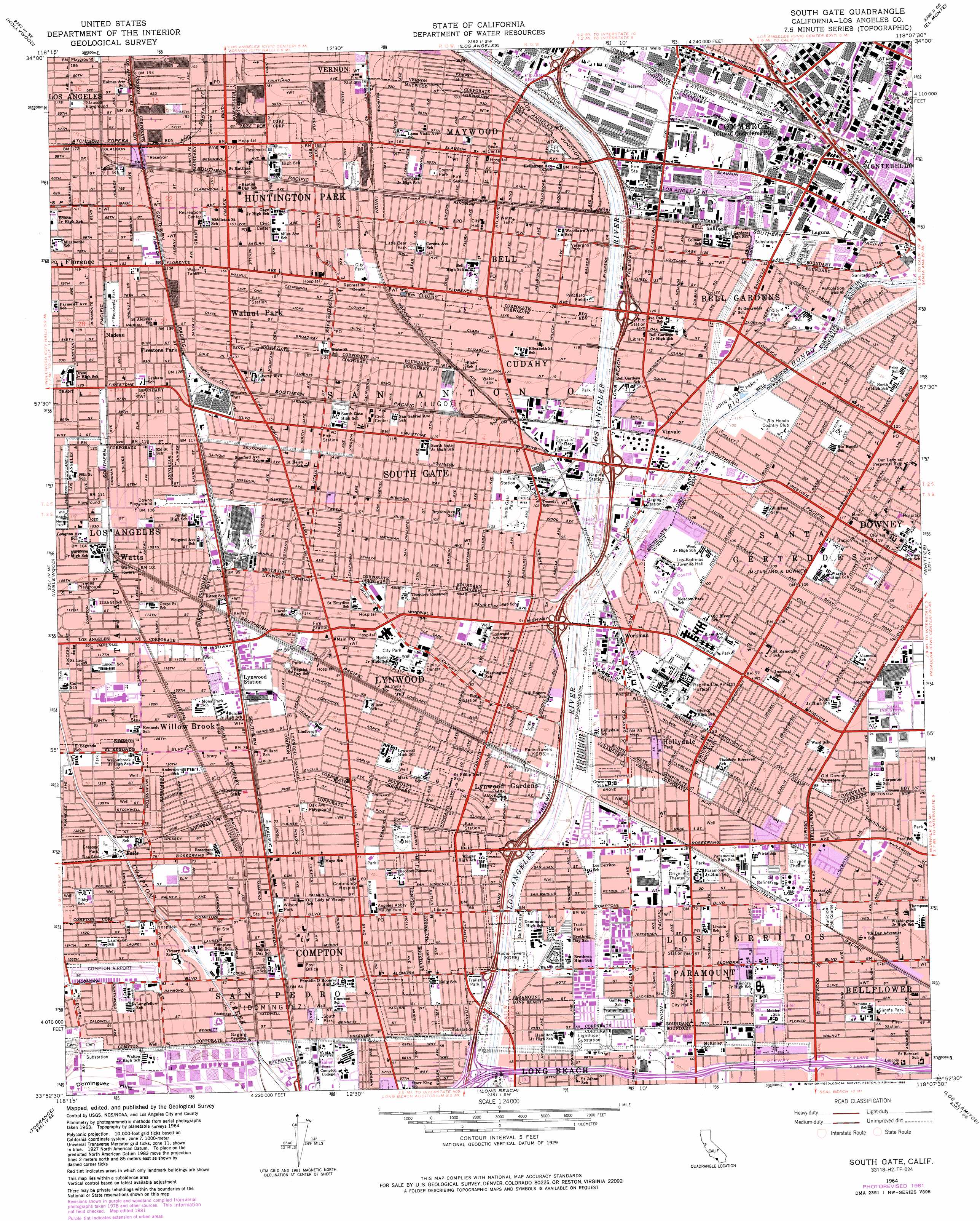
USGS Topo Quad 33118h2 - 1:24,000 scale
| Topo Map Name: | South Gate |
| USGS Topo Quad ID: | 33118h2 |
| Print Size: | ca. 21 1/4" wide x 27" high |
| Southeast Coordinates: | 33.875° N latitude / 118.125° W longitude |
| Map Center Coordinates: | 33.9375° N latitude / 118.1875° W longitude |
| U.S. State: | CA |
| Filename: | o33118h2.jpg |
| Download Map JPG Image: | South Gate topo map 1:24,000 scale |
| Map Type: | Topographic |
| Topo Series: | 7.5´ |
| Map Scale: | 1:24,000 |
| Source of Map Images: | United States Geological Survey (USGS) |
| Alternate Map Versions: |
South Gate CA 1949, updated 1957 Download PDF Buy paper map South Gate CA 1949, updated 1960 Download PDF Buy paper map South Gate CA 1964, updated 1966 Download PDF Buy paper map South Gate CA 1964, updated 1975 Download PDF Buy paper map South Gate CA 1964, updated 1982 Download PDF Buy paper map South Gate CA 1964, updated 1988 Download PDF Buy paper map South Gate CA 2012 Download PDF Buy paper map South Gate CA 2015 Download PDF Buy paper map |
1:24,000 Topo Quads surrounding South Gate
Van Nuys |
Burbank |
Pasadena |
Mount Wilson |
Azusa |
Beverly Hills |
Hollywood |
Los Angeles |
El Monte |
Baldwin Park |
Venice |
Inglewood |
South Gate |
Whittier |
La Habra |
Redondo Beach |
Torrance |
Long Beach |
Los Alamitos |
Anaheim |
San Pedro |
Seal Beach |
Newport Beach |
> Back to 33118e1 at 1:100,000 scale
> Back to 33118a1 at 1:250,000 scale
> Back to U.S. Topo Maps home
South Gate topo map: Gazetteer
South Gate: Airports
Commerce Business Park Heliport elevation 42m 137′Compton Airport elevation 28m 91′
Los Angeles Eastside Airport (historical) elevation 48m 157′
R I Sd Downey Helistop elevation 31m 101′
Saint Francis Medical Center Helistop elevation 28m 91′
South Gate: Crossings
Exit 10 elevation 27m 88′Exit 126B elevation 50m 164′
Exit 128A elevation 50m 164′
Exit 128B elevation 47m 154′
Exit 12A elevation 29m 95′
Exit 12B elevation 30m 98′
Exit 12B elevation 18m 59′
Exit 12C elevation 15m 49′
Exit 13 elevation 33m 108′
Exit 13 elevation 18m 59′
Exit 14A elevation 19m 62′
Exit 14B elevation 19m 62′
Exit 15 elevation 38m 124′
Exit 15A elevation 19m 62′
Exit 15B elevation 20m 65′
Exit 16 elevation 21m 68′
Exit 17A elevation 55m 180′
Exit 17B elevation 46m 150′
Exit 8B elevation 19m 62′
Exit 9A elevation 21m 68′
Exit 9B elevation 20m 65′
South Gate: Parks
Apollo Park elevation 31m 101′Bell Gardens Park elevation 39m 127′
Brookshire Childrens Park elevation 31m 101′
Camp Suanga elevation 16m 52′
Carnation Park elevation 28m 91′
Clara Park elevation 39m 127′
Colonel Leo H Washington Park elevation 40m 131′
Corona Park elevation 48m 157′
Crawford Park elevation 35m 114′
Cudahy Park elevation 35m 114′
Darwell Park elevation 38m 124′
Doctor Walter R Tucker Park elevation 24m 78′
Downs Playground elevation 34m 111′
East Rancho Dominguez County Park elevation 21m 68′
Ellerman Park elevation 23m 75′
Furman Park elevation 38m 124′
Gallant Park elevation 35m 114′
Golden Park elevation 28m 91′
Gonzales Park elevation 25m 82′
Hollydale Park elevation 25m 82′
John A Ford Park elevation 36m 118′
John S Simms Park elevation 21m 68′
Kelly Park elevation 19m 62′
Lentz Field elevation 34m 111′
Little Bear Park elevation 45m 147′
Lugo Park elevation 25m 82′
Lugo Park elevation 39m 127′
Lynwood Park elevation 27m 88′
Marlow Park elevation 39m 127′
Maywood Park elevation 44m 144′
Middleton Street Recreation Center elevation 52m 170′
Miles Park elevation 50m 164′
Mona Park elevation 26m 85′
Oak Avenue Playground elevation 23m 75′
One Hundred Ninth Street Recreation Center elevation 31m 101′
Paramount Park elevation 23m 75′
Pequino Park elevation 25m 82′
Pixley Park elevation 51m 167′
Pritchard Field elevation 38m 124′
Progress Park elevation 22m 72′
Raymond Street Park elevation 22m 72′
Roosevelt Park elevation 45m 147′
Rose Park elevation 26m 85′
Salt Lake Park elevation 45m 147′
Sibrie Park elevation 26m 85′
Slauson Playground elevation 55m 180′
South Gate Park elevation 33m 108′
South Park elevation 19m 62′
Spane Park elevation 23m 75′
Stanford Avenue Park elevation 35m 114′
Steam Engine Park elevation 23m 75′
Thompson Park elevation 27m 88′
Treasure Island Park elevation 43m 141′
Treder Park elevation 45m 147′
Veterans Memorial Park elevation 44m 144′
Veterans Park elevation 40m 131′
Village Park elevation 22m 72′
Village Park elevation 22m 72′
Watts Senior Center elevation 35m 114′
Watts Towers State Historical Park elevation 32m 104′
Westside Park elevation 51m 167′
Wilson Park elevation 22m 72′
South Gate: Populated Places
Bell elevation 43m 141′Bell Gardens elevation 37m 121′
Clearwater elevation 23m 75′
Compton elevation 21m 68′
Cudahy elevation 37m 121′
Downey elevation 36m 118′
East Compton elevation 22m 72′
El Rancho Mobile Home Park elevation 20m 65′
Firestone Park elevation 41m 134′
Florence elevation 46m 150′
Gage elevation 47m 154′
Graham elevation 39m 127′
Hacienda Village elevation 33m 108′
Hollydale elevation 25m 82′
Huntington Park elevation 52m 170′
Imperial Courts elevation 28m 91′
Jordan Downs elevation 34m 111′
Laguna elevation 46m 150′
Lynwood elevation 28m 91′
Lynwood Gardens elevation 24m 78′
Maywood elevation 46m 150′
Morton elevation 25m 82′
Nadeau elevation 43m 141′
Nickerson Gardens elevation 30m 98′
Paramount elevation 21m 68′
Pueblo Del Rio Public Housing elevation 56m 183′
Rendalia elevation 24m 78′
Simons elevation 50m 164′
South Gate elevation 35m 114′
Vinvale elevation 34m 111′
Walker elevation 42m 137′
Walnut Park elevation 45m 147′
Watts elevation 33m 108′
Willow Brook elevation 25m 82′
Workman elevation 29m 95′
South Gate: Post Offices
Bell Gardens Branch Bell Post Office elevation 39m 127′Bell Post Office elevation 45m 147′
Compton Post Office elevation 20m 65′
Downey Main Post Office elevation 35m 114′
Downey Post Office elevation 35m 114′
Firestone Station South Gate Post Office elevation 35m 114′
Hollydale Station South Gate Post Office elevation 25m 82′
Huntington Park Post Office elevation 50m 164′
Lynwood Main Post Office elevation 27m 88′
Maywood Post Office elevation 46m 150′
Paramount Post Office elevation 22m 72′
Soto Station Huntington Park Post Office elevation 54m 177′
South Downey Station Downey Post Office elevation 31m 101′
South Gate Post Office elevation 31m 101′
State Street Station Huntington Park Post Office elevation 43m 141′
Vernon Branch Los Angeles Post Office elevation 58m 190′
South Gate: Streams
Rio Hondo elevation 24m 78′South Gate digital topo map on disk
Buy this South Gate topo map showing relief, roads, GPS coordinates and other geographical features, as a high-resolution digital map file on DVD: