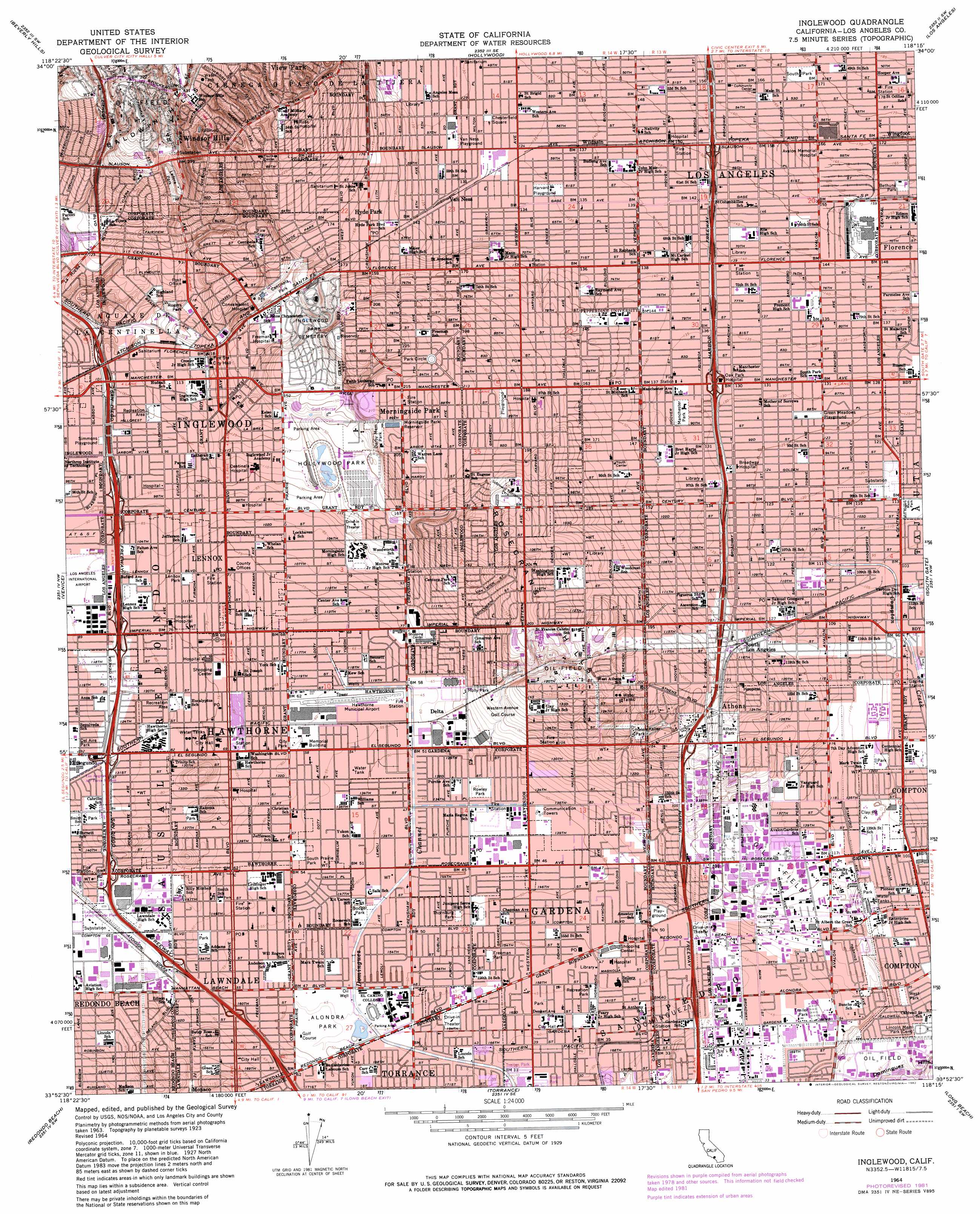
Inglewood Topo Map California
To zoom in, hover over the map of Inglewood
USGS Topo Quad 33118h3 - 1:24,000 scale
| Topo Map Name: | Inglewood |
| USGS Topo Quad ID: | 33118h3 |
| Print Size: | ca. 21 1/4" wide x 27" high |
| Southeast Coordinates: | 33.875° N latitude / 118.25° W longitude |
| Map Center Coordinates: | 33.9375° N latitude / 118.3125° W longitude |
| U.S. State: | CA |
| Filename: | o33118h3.jpg |
| Download Map JPG Image: | Inglewood topo map 1:24,000 scale |
| Map Type: | Topographic |
| Topo Series: | 7.5´ |
| Map Scale: | 1:24,000 |
| Source of Map Images: | United States Geological Survey (USGS) |
| Alternate Map Versions: |
Inglewood CA 1950, updated 1957 Download PDF Buy paper map Inglewood CA 1952 Download PDF Buy paper map Inglewood CA 1964, updated 1965 Download PDF Buy paper map Inglewood CA 1964, updated 1975 Download PDF Buy paper map Inglewood CA 1964, updated 1982 Download PDF Buy paper map Inglewood CA 1964, updated 1982 Download PDF Buy paper map Inglewood CA 2012 Download PDF Buy paper map Inglewood CA 2015 Download PDF Buy paper map |
1:24,000 Topo Quads surrounding Inglewood
Canoga Park |
Van Nuys |
Burbank |
Pasadena |
Mount Wilson |
Topanga |
Beverly Hills |
Hollywood |
Los Angeles |
El Monte |
Venice |
Inglewood |
South Gate |
Whittier |
|
Redondo Beach |
Torrance |
Long Beach |
Los Alamitos |
|
San Pedro |
Seal Beach |
> Back to 33118e1 at 1:100,000 scale
> Back to 33118a1 at 1:250,000 scale
> Back to U.S. Topo Maps home
Inglewood topo map: Gazetteer
Inglewood: Airports
Central Airport (historical) elevation 30m 98′Gardena Valley Airport (historical) elevation 14m 45′
Hawthorne Municipal Airport elevation 19m 62′
Kellys Airport (historical) elevation 26m 85′
Inglewood: Crossings
Exit 11 elevation 16m 52′Exit 12 elevation 23m 75′
Exit 13 elevation 46m 150′
Exit 15 elevation 46m 150′
Exit 16 elevation 46m 150′
Exit 17 elevation 46m 150′
Exit 18A elevation 48m 157′
Exit 18B elevation 55m 180′
Exit 2 elevation 31m 101′
Exit 40B elevation 22m 72′
Exit 42A elevation 22m 72′
Exit 42B elevation 24m 78′
Exit 43A elevation 26m 85′
Exit 43B elevation 28m 91′
Exit 44 elevation 31m 101′
Exit 45 elevation 26m 85′
Exit 46 elevation 31m 101′
Exit 47 elevation 23m 75′
Inglewood: Parks
Algin Sutton Recreation Center elevation 42m 137′Alondra Park elevation 15m 49′
Ashwood Park elevation 30m 98′
Athens Park elevation 48m 157′
Beach Boys Historic Landmark elevation 17m 55′
Bell Park elevation 16m 52′
Bethune Park elevation 49m 160′
Bicentennial Park elevation 18m 59′
Bodger Park elevation 15m 49′
Burrel McDonald Park elevation 29m 95′
Campanella Park elevation 33m 108′
Center Park elevation 22m 72′
Centinela Park elevation 44m 144′
Chesterfield Square elevation 41m 134′
Dale Page Park elevation 31m 101′
Darby Memorial Park elevation 63m 206′
Del Aire Park elevation 28m 91′
Enterprise Park elevation 31m 101′
Fortyeighth Street Park elevation 49m 160′
Freeman Park elevation 16m 52′
G W Carver Park elevation 26m 85′
Glen Anderson Park elevation 26m 85′
Green Meadows Playground elevation 39m 127′
Harvard Playground elevation 42m 137′
Hawthorne Memorial Park elevation 19m 62′
Helen Keller Park elevation 46m 150′
Holly Glen Park elevation 28m 91′
Holly Park elevation 32m 104′
Hollywood Park elevation 41m 134′
Jane Addams Park elevation 19m 62′
Jesse Owens County Park elevation 75m 246′
Jim Thorpe Park elevation 18m 59′
Ladera Park elevation 59m 193′
Lennox Park elevation 23m 75′
Malloy Park elevation 17m 55′
Monteith Park elevation 66m 216′
Mount Carmel Park elevation 44m 144′
Murdock Stadium elevation 11m 36′
Norman O Houston Park elevation 135m 442′
North Park elevation 69m 226′
Queen Park elevation 51m 167′
Recreation Park elevation 14m 45′
Rogers Park elevation 37m 121′
Rogers-Anderson Park elevation 16m 52′
Rosecrans Recreation Center elevation 16m 52′
Rowley Memorial Park elevation 14m 45′
Saint Andrews Recreation Center elevation 63m 206′
Sentinel Field elevation 31m 101′
Siminski Park elevation 30m 98′
Simmons Playground elevation 30m 98′
South Park elevation 53m 173′
Theresa Lindsay Park elevation 48m 157′
Thornburg Park elevation 16m 52′
Tragview Park elevation 31m 101′
Van Ness Playground elevation 41m 134′
Vernon Hemingway Memorial Park elevation 17m 55′
Will Rogers Memorial Park elevation 35m 114′
William Green Park elevation 28m 91′
Willowbrook Park elevation 34m 111′
Zella Davis Park elevation 17m 55′
Inglewood: Populated Places
Alondra Park elevation 16m 52′Athens elevation 52m 170′
Avalon Gardens elevation 40m 131′
Bridgedale elevation 13m 42′
Cypave elevation 17m 55′
Del Aire elevation 31m 101′
Delta elevation 18m 59′
Dorset Village elevation 48m 157′
Gardena elevation 15m 49′
Hawthorne elevation 22m 72′
Hermosillo elevation 11m 36′
Hyde Park elevation 50m 164′
Inglewood elevation 40m 131′
Lawndale elevation 18m 59′
Lennox elevation 22m 72′
Moneta elevation 13m 42′
Morningside Park elevation 67m 219′
South Los Angeles elevation 47m 154′
Strawberry Park elevation 15m 49′
Van Ness elevation 42m 137′
View Park elevation 97m 318′
West Athens elevation 58m 190′
West Compton elevation 25m 82′
Westmont elevation 66m 216′
Wildasin elevation 43m 141′
Willowbrook elevation 29m 95′
Windsor Hills elevation 98m 321′
Wingfoot elevation 53m 173′
Inglewood: Post Offices
Crenshaw Imperial Station Inglewood Post Office elevation 29m 95′Gardena Post Office elevation 16m 52′
Hancock Station Los Angeles Post Office elevation 44m 144′
Hillcrest Station Inglewood Post Office elevation 43m 141′
Lawndale Post Office elevation 18m 59′
Lennox Branch Inglewood Post Office elevation 23m 75′
Morningside Park Station Inglewood Post Office elevation 67m 219′
North Inglewood Station Inglewood Post Office elevation 37m 121′
Wagner Branch Station Los Angeles Post Office elevation 55m 180′
Inglewood: Ranges
Rosecrans Hills elevation 71m 232′Inglewood: Reservoirs
Morningside Park Reservoir elevation 66m 216′Inglewood digital topo map on disk
Buy this Inglewood topo map showing relief, roads, GPS coordinates and other geographical features, as a high-resolution digital map file on DVD: