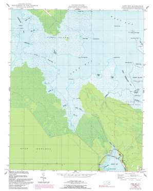
Long Bay Topo Map North Carolina
To zoom in, hover over the map of Long Bay
USGS Topo Quad 34076h4 - 1:24,000 scale
| Topo Map Name: | Long Bay |
| USGS Topo Quad ID: | 34076h4 |
| Print Size: | ca. 21 1/4" wide x 27" high |
| Southeast Coordinates: | 34.875° N latitude / 76.375° W longitude |
| Map Center Coordinates: | 34.9375° N latitude / 76.4375° W longitude |
| U.S. State: | NC |
| Filename: | o34076h4.jpg |
| Download Map JPG Image: | Long Bay topo map 1:24,000 scale |
| Map Type: | Topographic |
| Topo Series: | 7.5´ |
| Map Scale: | 1:24,000 |
| Source of Map Images: | United States Geological Survey (USGS) |
| Alternate Map Versions: |
Long Bay NC 1949, updated 1983 Download PDF Buy paper map Long Bay NC 1949, updated 1992 Download PDF Buy paper map Long Bay NC 1950 Download PDF Buy paper map Long Bay NC 1950 Download PDF Buy paper map Long Bay NC 2010 Download PDF Buy paper map Long Bay NC 2013 Download PDF Buy paper map Long Bay NC 2016 Download PDF Buy paper map |
1:24,000 Topo Quads surrounding Long Bay
> Back to 34076e1 at 1:100,000 scale
> Back to 34076a1 at 1:250,000 scale
> Back to U.S. Topo Maps home
Long Bay topo map: Gazetteer
Long Bay: Bays
Big Gut elevation 0m 0′Broad Creek elevation 0m 0′
Bull Creek elevation 0m 0′
Deep Gut elevation 0m 0′
Dowdy Bay elevation 0m 0′
Goose Bay elevation 0m 0′
Jacks Bay elevation 0m 0′
Long Bay elevation 0m 0′
Merkle Bay elevation 0m 0′
Owens Bay elevation 0m 0′
Piney Island Bay elevation 0m 0′
Sanborns Gut elevation 0m 0′
Stump Bay elevation 0m 0′
Turnagain Bay elevation 0m 0′
West Thorofare Bay elevation 0m 0′
Long Bay: Canals
Old Canal elevation 0m 0′Long Bay: Capes
Broad Creek Point elevation 0m 0′Corn Sage Point elevation 1m 3′
Hog Point elevation 1m 3′
Jacks Bay Point elevation 1m 3′
Long Bay Point elevation 0m 0′
Merkle Bay Point elevation 0m 0′
Swimming Point elevation 1m 3′
Tump Point elevation 1m 3′
Long Bay: Islands
Piney Island elevation 0m 0′Tump Island elevation 0m 0′
Long Bay: Streams
Benneys Creek elevation 0m 0′Cadduggen Creek elevation 0m 0′
Flag Creek elevation 0m 0′
Fur Creek elevation 0m 0′
Golden Creek elevation 0m 0′
Henrys Creek elevation 0m 0′
Mingo Creek elevation 1m 3′
Salters Creek elevation 0m 0′
Long Bay digital topo map on disk
Buy this Long Bay topo map showing relief, roads, GPS coordinates and other geographical features, as a high-resolution digital map file on DVD:
Atlantic Coast (NY, NJ, PA, DE, MD, VA, NC)
Buy digital topo maps: Atlantic Coast (NY, NJ, PA, DE, MD, VA, NC)


