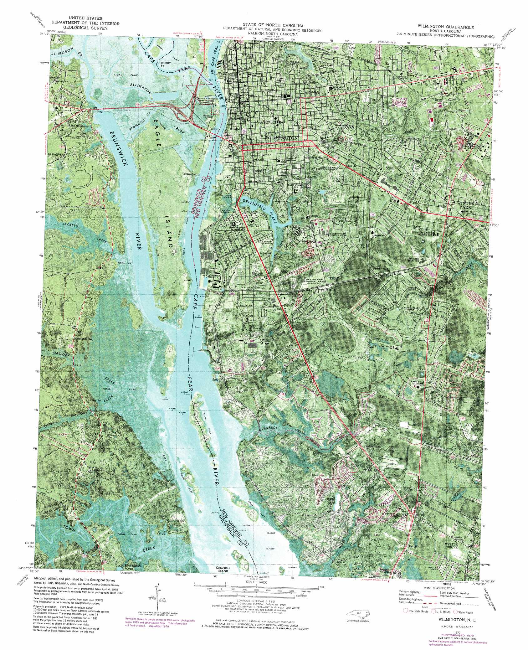
Wilmington Topo Map North Carolina
To zoom in, hover over the map of Wilmington
USGS Topo Quad 34077b8 - 1:24,000 scale
| Topo Map Name: | Wilmington |
| USGS Topo Quad ID: | 34077b8 |
| Print Size: | ca. 21 1/4" wide x 27" high |
| Southeast Coordinates: | 34.125° N latitude / 77.875° W longitude |
| Map Center Coordinates: | 34.1875° N latitude / 77.9375° W longitude |
| U.S. State: | NC |
| Filename: | p34077b8.jpg |
| Download Map JPG Image: | Wilmington topo map 1:24,000 scale |
| Map Type: | Orthophoto |
| Topo Series: | 7.5´ |
| Map Scale: | 1:24,000 |
| Source of Map Images: | United States Geological Survey (USGS) |
| Alternate Map Versions: |
Wilmington NC 1970, updated 1973 Download PDF Buy paper map Wilmington NC 1970, updated 1980 Download PDF Buy paper map Wilmington NC 1970, updated 1980 Download PDF Buy paper map Wilmington NC 1980, updated 1985 Download PDF Buy paper map Wilmington NC 1993, updated 1999 Download PDF Buy paper map Wilmington NC 2010 Download PDF Buy paper map Wilmington NC 2013 Download PDF Buy paper map Wilmington NC 2016 Download PDF Buy paper map |
1:24,000 Topo Quads surrounding Wilmington
Point Caswell |
Currie |
Rocky Point |
Mooretown |
Topsail |
Acme |
Leland |
Castle Hayne |
Scotts Hill |
Hampstead |
Lewis Swamp |
Winnabow |
Wilmington |
Wrightsville Beach |
|
Bolivia |
Funston |
Carolina Beach |
||
Lockwoods Folly |
Southport |
Kure Beach |
> Back to 34077a1 at 1:100,000 scale
> Back to 34076a1 at 1:250,000 scale
> Back to U.S. Topo Maps home
Wilmington topo map: Gazetteer
Wilmington: Capes
Dream Tree Point elevation 1m 3′Muddy Point elevation 0m 0′
Peter Point elevation 2m 6′
Wilmington: Channels
Big I Lower Range elevation 0m 0′Fourth East Jetty Range elevation 1m 3′
Lower Brunswick Range elevation 0m 0′
Upper Brunswick Range elevation 0m 0′
Wilmington: Dams
Greenfield Lake Dam elevation 2m 6′Wilmington: Islands
Clarks Island elevation 3m 9′Eagle Island elevation 4m 13′
Wilmington: Lakes
Silver Lake elevation 4m 13′Wilmington: Parks
Beaumont Park elevation 7m 22′Empie Park elevation 12m 39′
Legion Stadium elevation 4m 13′
Mac Rea Park elevation 11m 36′
Optimist Park elevation 1m 3′
University of North Carolina - Wilmington Campus Trask Coliseum elevation 13m 42′
USS North Carolina elevation 2m 6′
Wilmington: Populated Places
Arrowhead elevation 7m 22′Azalea Mobile Home Park elevation 12m 39′
Baldwin Estates Mobile Home Park elevation 7m 22′
Barclay Hills elevation 11m 36′
Belville elevation 1m 3′
Bowdens Mobile Home Park elevation 5m 16′
Charter Oaks Mobile Home Park elevation 11m 36′
Clairmont elevation 2m 6′
Delgado elevation 10m 32′
Devon Park elevation 11m 36′
Echo Farms elevation 5m 16′
Fairlawn elevation 11m 36′
Forest Hills elevation 9m 29′
Glen Meade elevation 19m 62′
Grants Mobile Home Park elevation 10m 32′
Greenbriar elevation 7m 22′
Grove Park Mobile Home Estates elevation 8m 26′
Hinsons Mobile Home Park elevation 9m 29′
Lake Forest elevation 10m 32′
Langleys Mobile Home Park Number 2 elevation 9m 29′
Lincoln Forest elevation 12m 39′
Maple Avenue Mobile Home Park elevation 12m 39′
Marquis Hills elevation 4m 13′
Myrtle Grove elevation 8m 26′
Myrtle Grove Junction elevation 8m 26′
Old Town elevation 3m 9′
Peachtree Mobile Home Park elevation 12m 39′
Pine Terrace Mobile Home Park elevation 10m 32′
Pine Valley Estates elevation 12m 39′
Ponderosa Mobile Home Park elevation 12m 39′
Princess Place elevation 7m 22′
Riverfront Mobile Home Park elevation 4m 13′
Royal Palms Mobile Home Park elevation 4m 13′
Silver Lake elevation 10m 32′
Silver Lake Mobile Home Park elevation 8m 26′
South Oleander elevation 13m 42′
Sunset Park elevation 8m 26′
Wilmington elevation 11m 36′
Winter Park elevation 12m 39′
Wilmington: Post Offices
Azalea Post Office elevation 12m 39′Dogwood Post Office elevation 9m 29′
Myrtle Grove Post Office elevation 9m 29′
Wilmington Post Office elevation 9m 29′
Wilmington: Reservoirs
Beaverdam Pond elevation 3m 9′Greenfield Lake elevation 2m 6′
McIlhennys Pond (historical) elevation 1m 3′
Wilmington: Streams
Alligator Creek elevation 1m 3′Barnards Creek elevation 1m 3′
Brunswick River elevation 0m 0′
Greenfield Creek elevation 0m 0′
Jackeys Creek elevation 1m 3′
Little Mallory Creek elevation 0m 0′
Mallory Creek elevation 1m 3′
Northeast Cape Fear River elevation 1m 3′
Redmond Creek elevation 0m 0′
Sturgeon Creek elevation 0m 0′
Town Creek elevation 0m 0′
Wilmington: Trails
Mohican Trail elevation 7m 22′Wilmington digital topo map on disk
Buy this Wilmington topo map showing relief, roads, GPS coordinates and other geographical features, as a high-resolution digital map file on DVD:
Atlantic Coast (NY, NJ, PA, DE, MD, VA, NC)
Buy digital topo maps: Atlantic Coast (NY, NJ, PA, DE, MD, VA, NC)
 map DVD")