Burgaw Topo Map North Carolina
To zoom in, hover over the map of Burgaw
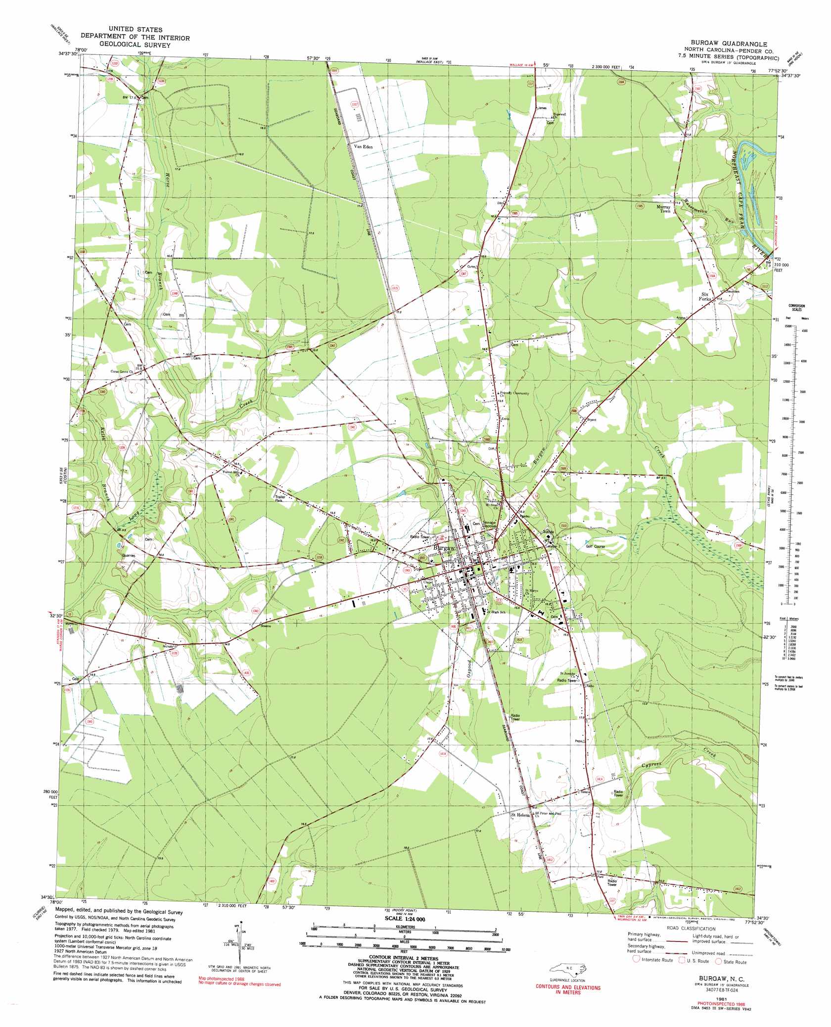
USGS Topo Quad 34077e8 - 1:24,000 scale
| Topo Map Name: | Burgaw |
| USGS Topo Quad ID: | 34077e8 |
| Print Size: | ca. 21 1/4" wide x 27" high |
| Southeast Coordinates: | 34.5° N latitude / 77.875° W longitude |
| Map Center Coordinates: | 34.5625° N latitude / 77.9375° W longitude |
| U.S. State: | NC |
| Filename: | o34077e8.jpg |
| Download Map JPG Image: | Burgaw topo map 1:24,000 scale |
| Map Type: | Topographic |
| Topo Series: | 7.5´ |
| Map Scale: | 1:24,000 |
| Source of Map Images: | United States Geological Survey (USGS) |
| Alternate Map Versions: |
Burgaw NC 1981, updated 1981 Download PDF Buy paper map Burgaw NC 1981, updated 1992 Download PDF Buy paper map Burgaw NC 2010 Download PDF Buy paper map Burgaw NC 2013 Download PDF Buy paper map Burgaw NC 2016 Download PDF Buy paper map |
1:24,000 Topo Quads surrounding Burgaw
Delway |
Rose Hill |
Charity |
Chinquapin |
Lyman |
Harrells |
Wallace West |
Wallace East |
Pin Hook |
Maple Hill |
Atkinson |
Costin |
Burgaw |
Stag Park |
Maple Hill Sw |
Point Caswell |
Currie |
Rocky Point |
Mooretown |
Topsail |
Acme |
Leland |
Castle Hayne |
Scotts Hill |
Hampstead |
> Back to 34077e1 at 1:100,000 scale
> Back to 34076a1 at 1:250,000 scale
> Back to U.S. Topo Maps home
Burgaw topo map: Gazetteer
Burgaw: Populated Places
Burgaw elevation 15m 49′Murray Town elevation 11m 36′
Saint Helena elevation 16m 52′
Six Forks elevation 10m 32′
Van Eden elevation 18m 59′
Burgaw: Post Offices
Burgaw Post Office elevation 13m 42′Burgaw: Streams
East Prong of Osgood Branch elevation 17m 55′Horse Branch elevation 10m 32′
Keith Branch elevation 8m 26′
Little Burgaw Creek elevation 16m 52′
Osgood Branch elevation 9m 29′
Resoe Creek elevation 14m 45′
Watermelon Run elevation 1m 3′
West Prong of Osgood Branch elevation 17m 55′
Burgaw digital topo map on disk
Buy this Burgaw topo map showing relief, roads, GPS coordinates and other geographical features, as a high-resolution digital map file on DVD:
Atlantic Coast (NY, NJ, PA, DE, MD, VA, NC)
Buy digital topo maps: Atlantic Coast (NY, NJ, PA, DE, MD, VA, NC)
 map DVD")