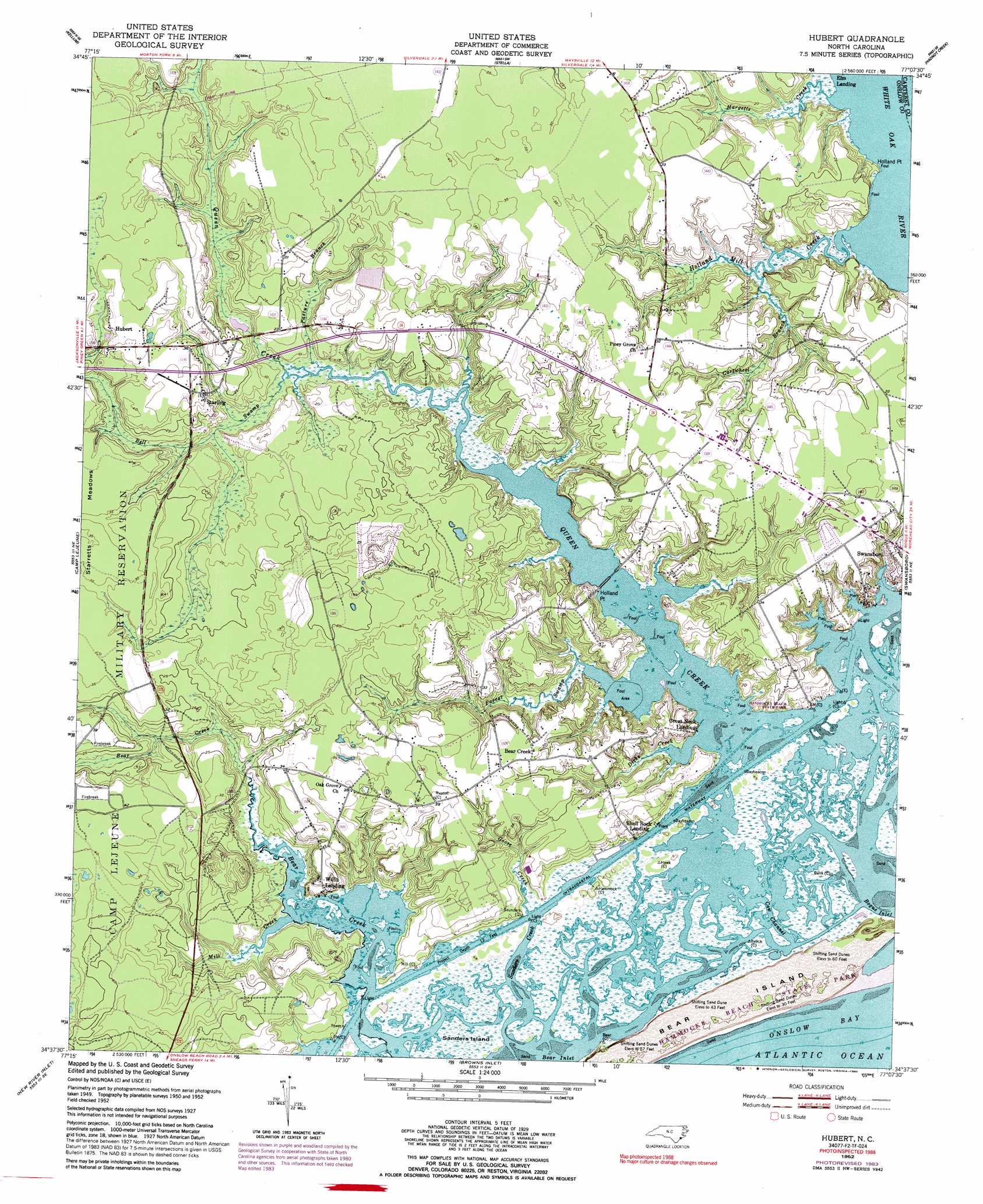
Hubert Topo Map North Carolina
To zoom in, hover over the map of Hubert
USGS Topo Quad 34077f2 - 1:24,000 scale
| Topo Map Name: | Hubert |
| USGS Topo Quad ID: | 34077f2 |
| Print Size: | ca. 21 1/4" wide x 27" high |
| Southeast Coordinates: | 34.625° N latitude / 77.125° W longitude |
| Map Center Coordinates: | 34.6875° N latitude / 77.1875° W longitude |
| U.S. State: | NC |
| Filename: | o34077f2.jpg |
| Download Map JPG Image: | Hubert topo map 1:24,000 scale |
| Map Type: | Topographic |
| Topo Series: | 7.5´ |
| Map Scale: | 1:24,000 |
| Source of Map Images: | United States Geological Survey (USGS) |
| Alternate Map Versions: |
Hubert NC 1952, updated 1954 Download PDF Buy paper map Hubert NC 1952, updated 1973 Download PDF Buy paper map Hubert NC 1952, updated 1992 Download PDF Buy paper map Hubert NC 1997, updated 2000 Download PDF Buy paper map Hubert NC 2010 Download PDF Buy paper map Hubert NC 2013 Download PDF Buy paper map Hubert NC 2016 Download PDF Buy paper map |
1:24,000 Topo Quads surrounding Hubert
Jacksonville Nw |
Jacksonville Ne |
Maysville |
Catfish Lake |
Havelock |
Jacksonville North |
Kellum |
Stella |
Hadnot Creek |
Masontown |
Jacksonville South |
Camp Lejeune |
Hubert |
Swansboro |
Salter Path |
Sneads Ferry |
New River Inlet |
Browns Inlet |
||
Spicer Bay |
> Back to 34077e1 at 1:100,000 scale
> Back to 34076a1 at 1:250,000 scale
> Back to U.S. Topo Maps home
Hubert topo map: Gazetteer
Hubert: Beaches
Headys Beach elevation 0m 0′Hubert: Capes
Holland Point elevation 2m 6′Holland Point elevation 3m 9′
Hubert: Channels
Cow Channel elevation -2m -7′Hubert: Guts
Sanders Creek elevation 0m 0′Hubert: Islands
Bear Island elevation 1m 3′Bear Island elevation 4m 13′
Finns Island elevation 2m 6′
Sanders Island elevation 0m 0′
Saunders Island elevation 0m 0′
Hubert: Parks
Hammocks Beach State Park elevation 4m 13′Hubert: Populated Places
Bear Creek elevation 10m 32′Hubert elevation 12m 39′
Lillipad Mobile Home Park elevation 8m 26′
Queen Creek Mobile Home Park elevation 12m 39′
Reid Acres Mobile Home Park elevation 7m 22′
Royal Valley Mobile Home Park elevation 11m 36′
Sea Pines Mobile Home Park elevation 10m 32′
Starling elevation 10m 32′
Sunshine Acres Mobile Home Park elevation 5m 16′
The Pines Mobile Home Park elevation 12m 39′
Turtle Cove Mobile Home Park elevation 10m 32′
Willis Landing elevation 5m 16′
Hubert: Post Offices
Hubert Post Office elevation 11m 36′Hubert: Streams
Bell Swamp elevation 6m 19′Cartwhell Branch elevation 0m 0′
Dicks Creek elevation 0m 0′
Goose Creek elevation 4m 13′
Hargetts Creek elevation 0m 0′
Holland Mill Creek elevation 3m 9′
Mill Creek elevation 0m 0′
Parrot Swamp elevation 0m 0′
Pasture Branch elevation 0m 0′
Queen Creek elevation 0m 0′
Hubert digital topo map on disk
Buy this Hubert topo map showing relief, roads, GPS coordinates and other geographical features, as a high-resolution digital map file on DVD:
Atlantic Coast (NY, NJ, PA, DE, MD, VA, NC)
Buy digital topo maps: Atlantic Coast (NY, NJ, PA, DE, MD, VA, NC)
 map DVD")