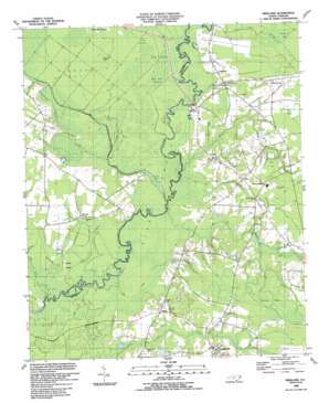
Freeland Topo Map North Carolina
To zoom in, hover over the map of Freeland
USGS Topo Quad 34078a5 - 1:24,000 scale
| Topo Map Name: | Freeland |
| USGS Topo Quad ID: | 34078a5 |
| Print Size: | ca. 21 1/4" wide x 27" high |
| Southeast Coordinates: | 34° N latitude / 78.5° W longitude |
| Map Center Coordinates: | 34.0625° N latitude / 78.5625° W longitude |
| U.S. State: | NC |
| Filename: | o34078a5.jpg |
| Download Map JPG Image: | Freeland topo map 1:24,000 scale |
| Map Type: | Topographic |
| Topo Series: | 7.5´ |
| Map Scale: | 1:24,000 |
| Source of Map Images: | United States Geological Survey (USGS) |
| Alternate Map Versions: |
Freeland NC 1943, updated 1962 Download PDF Buy paper map Freeland NC 1990, updated 1991 Download PDF Buy paper map Freeland NC 2010 Download PDF Buy paper map Freeland NC 2013 Download PDF Buy paper map Freeland NC 2016 Download PDF Buy paper map |
1:24,000 Topo Quads surrounding Freeland
> Back to 34078a1 at 1:100,000 scale
> Back to 34078a1 at 1:250,000 scale
> Back to U.S. Topo Maps home
Freeland topo map: Gazetteer
Freeland: Bridges
Bear Branch Bridge elevation 10m 32′Scippio Bridge elevation 8m 26′
Wet Ash Bridge elevation 9m 29′
Freeland: Islands
Beech Island elevation 7m 22′Cow Pen Island elevation 11m 36′
Freeland: Lakes
Gore Lake elevation 7m 22′Joe Lake elevation 6m 19′
Freeland: Parks
Waccamaw Township District Park elevation 20m 65′Freeland: Populated Places
Ash elevation 15m 49′Freeland elevation 11m 36′
Little Prong elevation 17m 55′
Longwood elevation 14m 45′
New Britton elevation 14m 45′
Reeves elevation 10m 32′
Regan elevation 13m 42′
Freeland: Post Offices
Ash Post Office elevation 15m 49′Freeland: Reservoirs
Butler Pond elevation 11m 36′Freeland: Streams
Bear Branch elevation 8m 26′Flat Branch elevation 10m 32′
Freeland Branch elevation 9m 29′
Gore Branch elevation 9m 29′
Gore Creek elevation 8m 26′
Horse Pen Swamp elevation 11m 36′
Milliken Swamp elevation 11m 36′
Possum Branch elevation 8m 26′
Regan Branch elevation 7m 22′
Seven Creeks elevation 6m 19′
Simmons Bay Creek elevation 7m 22′
Ward Branch elevation 10m 32′
Wet Ash Swamp elevation 8m 26′
Freeland: Summits
Sand Hill elevation 14m 45′Freeland: Swamps
Bee Tree Swamp elevation 8m 26′Clayton Bay elevation 13m 42′
Hog Swamp elevation 9m 29′
King Swamp elevation 8m 26′
Long Bays elevation 20m 65′
River Swamp elevation 7m 22′
Simmons Bay elevation 9m 29′
Soldier Bay elevation 17m 55′
Freeland digital topo map on disk
Buy this Freeland topo map showing relief, roads, GPS coordinates and other geographical features, as a high-resolution digital map file on DVD:
South Carolina, Western North Carolina & Northeastern Georgia
Buy digital topo maps: South Carolina, Western North Carolina & Northeastern Georgia


