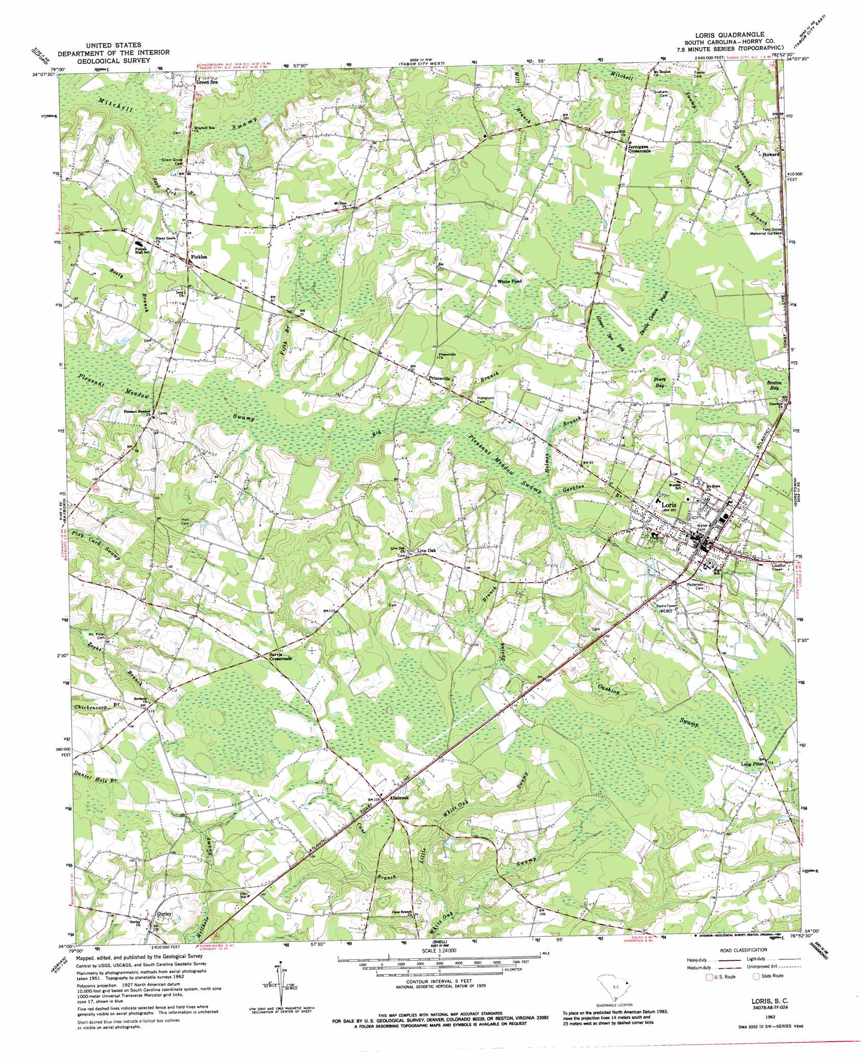
Loris Topo Map South Carolina
To zoom in, hover over the map of Loris
USGS Topo Quad 34078a8 - 1:24,000 scale
| Topo Map Name: | Loris |
| USGS Topo Quad ID: | 34078a8 |
| Print Size: | ca. 21 1/4" wide x 27" high |
| Southeast Coordinates: | 34° N latitude / 78.875° W longitude |
| Map Center Coordinates: | 34.0625° N latitude / 78.9375° W longitude |
| U.S. State: | SC |
| Filename: | o34078a8.jpg |
| Download Map JPG Image: | Loris topo map 1:24,000 scale |
| Map Type: | Topographic |
| Topo Series: | 7.5´ |
| Map Scale: | 1:24,000 |
| Source of Map Images: | United States Geological Survey (USGS) |
| Alternate Map Versions: |
Loris SC 1962, updated 1964 Download PDF Buy paper map Loris SC 1962, updated 1987 Download PDF Buy paper map Loris SC 2011 Download PDF Buy paper map Loris SC 2014 Download PDF Buy paper map |
1:24,000 Topo Quads surrounding Loris
Lake View |
Fair Bluff |
Cerro Gordo |
Chadbourn |
Whiteville |
Nichols |
Duford |
Tabor City West |
Tabor City East |
Nakina |
Galivants Ferry |
Bayboro |
Loris |
Goretown |
Pireway |
Horry |
Adrian |
Shell |
Hammond |
Longs |
Dongola |
Conway |
Nixonville |
Hand |
Wampee |
> Back to 34078a1 at 1:100,000 scale
> Back to 34078a1 at 1:250,000 scale
> Back to U.S. Topo Maps home
Loris topo map: Gazetteer
Loris: Airports
Loris Community Hospital Heliport elevation 29m 95′Loris: Dams
Allsbrook Pond Dam D-3619 elevation 24m 78′Loris Oxidation Pond Dam D-3615 elevation 23m 75′
Loris: Populated Places
Allsbrook elevation 32m 104′Finklea elevation 26m 85′
Glenn elevation 32m 104′
Gurley elevation 32m 104′
Howard elevation 28m 91′
Jernigans Crossroads elevation 30m 98′
Live Oak elevation 32m 104′
Long Point elevation 33m 108′
Loris elevation 30m 98′
Princeville elevation 27m 88′
Sarvis Crossroads elevation 33m 108′
White Pond elevation 35m 114′
Loris: Post Offices
Loris Post Office elevation 28m 91′Loris: Reservoirs
Allsbrook Pond elevation 24m 78′Loris Oxidation Pond elevation 23m 75′
Loris: Streams
Big Branch elevation 19m 62′Cane Branch elevation 17m 55′
Fifth Branch elevation 19m 62′
Gaskins Branch elevation 21m 68′
Holmes Branch elevation 20m 65′
Iron Springs Swamp elevation 17m 55′
Little White Oak Swamp elevation 16m 52′
Rooty Branch elevation 18m 59′
Savannah Branch elevation 26m 85′
Seed Tick Branch elevation 19m 62′
Spring Branch elevation 21m 68′
Loris: Swamps
Benton Bay elevation 29m 95′Cushion Swamp elevation 32m 104′
Devils Cotton Patch elevation 29m 95′
Fox Bay elevation 33m 108′
Green Sea Bay elevation 30m 98′
Piney Bay elevation 31m 101′
Loris digital topo map on disk
Buy this Loris topo map showing relief, roads, GPS coordinates and other geographical features, as a high-resolution digital map file on DVD:
South Carolina, Western North Carolina & Northeastern Georgia
Buy digital topo maps: South Carolina, Western North Carolina & Northeastern Georgia