Nakina Topo Map North Carolina
To zoom in, hover over the map of Nakina
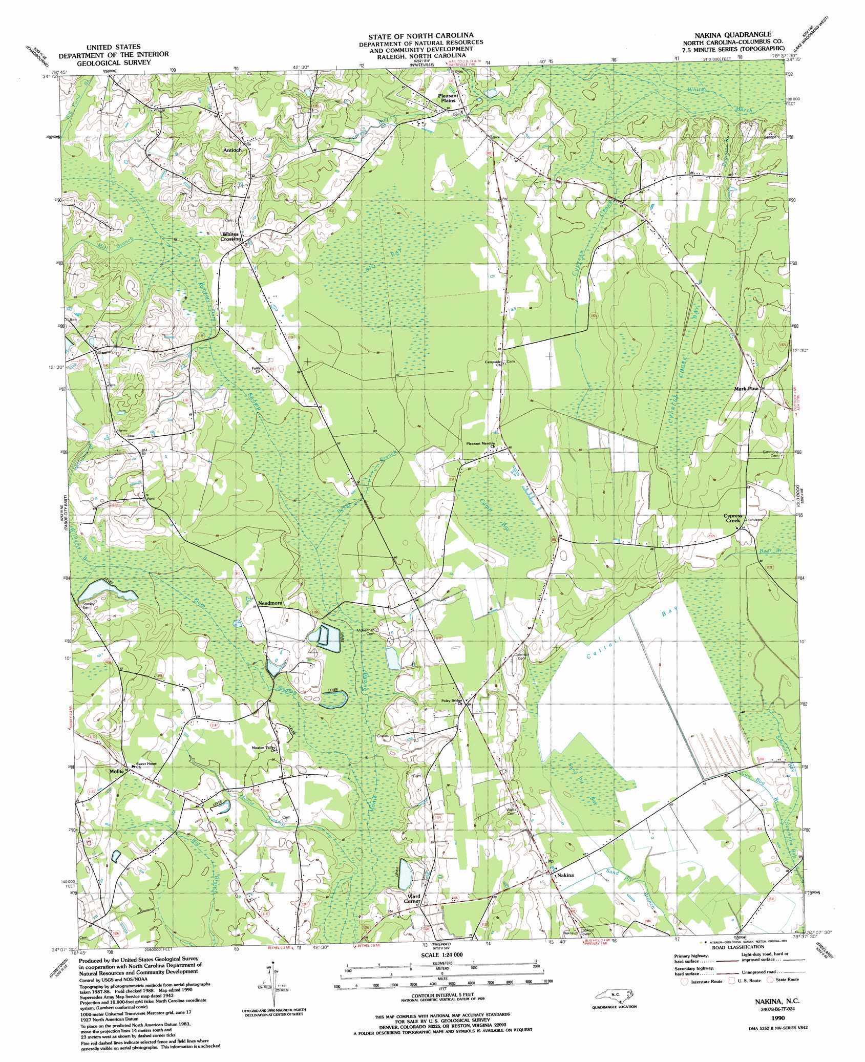
USGS Topo Quad 34078b6 - 1:24,000 scale
| Topo Map Name: | Nakina |
| USGS Topo Quad ID: | 34078b6 |
| Print Size: | ca. 21 1/4" wide x 27" high |
| Southeast Coordinates: | 34.125° N latitude / 78.625° W longitude |
| Map Center Coordinates: | 34.1875° N latitude / 78.6875° W longitude |
| U.S. State: | NC |
| Filename: | o34078b6.jpg |
| Download Map JPG Image: | Nakina topo map 1:24,000 scale |
| Map Type: | Topographic |
| Topo Series: | 7.5´ |
| Map Scale: | 1:24,000 |
| Source of Map Images: | United States Geological Survey (USGS) |
| Alternate Map Versions: |
Nakina NC 1943 Download PDF Buy paper map Nakina NC 1943, updated 1950 Download PDF Buy paper map Nakina NC 1990, updated 1991 Download PDF Buy paper map Nakina NC 2010 Download PDF Buy paper map Nakina NC 2013 Download PDF Buy paper map Nakina NC 2016 Download PDF Buy paper map |
1:24,000 Topo Quads surrounding Nakina
Evergreen |
Chadbourn Ne |
Clarkton |
Emerson |
Council |
Cerro Gordo |
Chadbourn |
Whiteville |
Lake Waccamaw West |
Lake Waccamaw East |
Tabor City West |
Tabor City East |
Nakina |
Old Dock |
Juniper Creek |
Loris |
Goretown |
Pireway |
Freeland |
Exum |
Shell |
Hammond |
Longs |
Calabash |
Shallotte |
> Back to 34078a1 at 1:100,000 scale
> Back to 34078a1 at 1:250,000 scale
> Back to U.S. Topo Maps home
Nakina topo map: Gazetteer
Nakina: Bridges
Boggy Branch Bridge elevation 14m 45′Cypress Creek Bridges elevation 16m 52′
Nellie Ford Bridge elevation 15m 49′
Peniten Bridges elevation 11m 36′
Pleasant Plains Bridge elevation 15m 49′
Pole Bridge elevation 20m 65′
Sand Pit Bridge elevation 11m 36′
Simmons Bay Bridge elevation 10m 32′
Stanley Ford Bridge elevation 13m 42′
Nakina: Canals
Peniten Canal elevation 12m 39′Nakina: Guts
Simmons Bay Creek elevation 10m 32′Nakina: Lakes
Sand Pit Bay elevation 14m 45′Nakina: Populated Places
Antioch elevation 32m 104′Cypress Creek elevation 15m 49′
Mark Pine elevation 20m 65′
Mollie elevation 18m 59′
Nakina elevation 14m 45′
Needmore elevation 16m 52′
Pleasant Plains elevation 17m 55′
Poley Bridge Crossing (historical) elevation 21m 68′
Simmons Bay elevation 12m 39′
Ward Corner elevation 17m 55′
Whites Crossing elevation 23m 75′
Nakina: Streams
Beaver Dam Swamp elevation 13m 42′Boggy Branch elevation 14m 45′
Cow Bog Branch elevation 11m 36′
Cypress Branch elevation 14m 45′
Cypress Creek elevation 15m 49′
Gum Swamp elevation 12m 39′
Lebanon Branch elevation 17m 55′
Loggy Branch elevation 13m 42′
Mill Branch elevation 14m 45′
Mill Branch elevation 19m 62′
Mill Branch Swamp elevation 13m 42′
Mollie Swamp elevation 12m 39′
Register Branch elevation 13m 42′
Williams Branch elevation 16m 52′
Nakina: Swamps
Big Bay elevation 17m 55′Camp Bay elevation 18m 59′
Cattail Bay elevation 12m 39′
Cypress Creek Bay elevation 22m 72′
Nakina digital topo map on disk
Buy this Nakina topo map showing relief, roads, GPS coordinates and other geographical features, as a high-resolution digital map file on DVD:
South Carolina, Western North Carolina & Northeastern Georgia
Buy digital topo maps: South Carolina, Western North Carolina & Northeastern Georgia