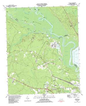
Leland Topo Map North Carolina
To zoom in, hover over the map of Leland
USGS Topo Quad 34078c1 - 1:24,000 scale
| Topo Map Name: | Leland |
| USGS Topo Quad ID: | 34078c1 |
| Print Size: | ca. 21 1/4" wide x 27" high |
| Southeast Coordinates: | 34.25° N latitude / 78° W longitude |
| Map Center Coordinates: | 34.3125° N latitude / 78.0625° W longitude |
| U.S. State: | NC |
| Filename: | o34078c1.jpg |
| Download Map JPG Image: | Leland topo map 1:24,000 scale |
| Map Type: | Topographic |
| Topo Series: | 7.5´ |
| Map Scale: | 1:24,000 |
| Source of Map Images: | United States Geological Survey (USGS) |
| Alternate Map Versions: |
Leland NC 1980, updated 1985 Download PDF Buy paper map Leland NC 1984, updated 1984 Download PDF Buy paper map Leland NC 1984, updated 1984 Download PDF Buy paper map Leland NC 1997, updated 2001 Download PDF Buy paper map Leland NC 2011 Download PDF Buy paper map Leland NC 2013 Download PDF Buy paper map Leland NC 2016 Download PDF Buy paper map |
1:24,000 Topo Quads surrounding Leland
> Back to 34078a1 at 1:100,000 scale
> Back to 34078a1 at 1:250,000 scale
> Back to U.S. Topo Maps home
Leland topo map: Gazetteer
Leland: Bays
Field Cove elevation 2m 6′Leland: Bends
Bulldog Cut elevation 1m 3′Devils Elbow elevation 1m 3′
Leland: Capes
Alligator Point elevation 2m 6′Big Island elevation 8m 26′
Bill Neal Island elevation 1m 3′
Maultbys Point elevation 1m 3′
Turkey Point elevation 1m 3′
Leland: Flats
Pine Pole Neck elevation 6m 19′Leland: Guts
Black River Cut elevation 1m 3′Field Creek elevation 1m 3′
Lyon Thorofare elevation 1m 3′
Leland: Islands
Raccoon Island elevation 1m 3′Roan Island elevation 1m 3′
Leland: Populated Places
Cedar Hill elevation 7m 22′Eastbrook elevation 11m 36′
Hooper Hill elevation 13m 42′
Leland elevation 7m 22′
Malmo elevation 19m 62′
Navassa elevation 6m 19′
Phoenix elevation 11m 36′
Leland: Streams
Alligator Branch elevation 4m 13′Banton Branch elevation 2m 6′
Bay Branch elevation 3m 9′
Bay Branch elevation 1m 3′
Black River elevation 1m 3′
Cherry Tree Prong elevation 2m 6′
Clabber Branch elevation 5m 16′
Cowpen Branch elevation 11m 36′
Double Run elevation 1m 3′
George Brown Branch elevation 3m 9′
Gibbs Creek elevation 1m 3′
Grist Mill Branch elevation 1m 3′
Hood Creek elevation 1m 3′
Indian Creek elevation 1m 3′
Line Creek elevation 0m 0′
Lyon Creek elevation 1m 3′
Machine Creek elevation 0m 0′
Mill Branch elevation 0m 0′
Mulberry Branch elevation 1m 3′
Neal Branch elevation 1m 3′
Otter Branch elevation 1m 3′
Rattlesnake Branch elevation 1m 3′
Rowel Branch elevation 2m 6′
Skipper Hill Branch elevation 3m 9′
Leland: Swamps
Big Bay elevation 14m 45′Dollisons Swamp elevation 1m 3′
Flat Bay elevation 14m 45′
Juniper Bay elevation 8m 26′
Long Bay elevation 21m 68′
Long Bay elevation 8m 26′
Ready Bay elevation 13m 42′
Singed Pig Bay elevation 10m 32′
Two Pond Bay elevation 7m 22′
Vines Bay elevation 7m 22′
Wildcat Bay elevation 13m 42′
Leland digital topo map on disk
Buy this Leland topo map showing relief, roads, GPS coordinates and other geographical features, as a high-resolution digital map file on DVD:
South Carolina, Western North Carolina & Northeastern Georgia
Buy digital topo maps: South Carolina, Western North Carolina & Northeastern Georgia


