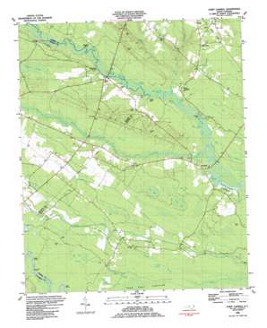
Point Caswell Topo Map North Carolina
To zoom in, hover over the map of Point Caswell
USGS Topo Quad 34078d2 - 1:24,000 scale
| Topo Map Name: | Point Caswell |
| USGS Topo Quad ID: | 34078d2 |
| Print Size: | ca. 21 1/4" wide x 27" high |
| Southeast Coordinates: | 34.375° N latitude / 78.125° W longitude |
| Map Center Coordinates: | 34.4375° N latitude / 78.1875° W longitude |
| U.S. State: | NC |
| Filename: | o34078d2.jpg |
| Download Map JPG Image: | Point Caswell topo map 1:24,000 scale |
| Map Type: | Topographic |
| Topo Series: | 7.5´ |
| Map Scale: | 1:24,000 |
| Source of Map Images: | United States Geological Survey (USGS) |
| Alternate Map Versions: |
Point Caswell NC 1980, updated 1985 Download PDF Buy paper map Point Caswell NC 1983, updated 1984 Download PDF Buy paper map Point Caswell NC 1997, updated 2001 Download PDF Buy paper map Point Caswell NC 2010 Download PDF Buy paper map Point Caswell NC 2013 Download PDF Buy paper map Point Caswell NC 2016 Download PDF Buy paper map |
1:24,000 Topo Quads surrounding Point Caswell
> Back to 34078a1 at 1:100,000 scale
> Back to 34078a1 at 1:250,000 scale
> Back to U.S. Topo Maps home
Point Caswell topo map: Gazetteer
Point Caswell: Basins
Black Bay elevation 7m 22′Flat Bay elevation 7m 22′
Long Bay elevation 6m 19′
Point Caswell: Bays
Aldermans Cove elevation 1m 3′Betty Hole Cove elevation 2m 6′
Colvins Cove elevation 1m 3′
Gaylor Cove elevation 1m 3′
Kelley Cove elevation 1m 3′
Larkins Cove elevation 1m 3′
Rock Hole Cove elevation 1m 3′
Wilson Cove elevation 2m 6′
Point Caswell: Canals
Lyon Swamp Canal elevation 5m 16′Point Caswell: Flats
Hunts Bluff elevation 3m 9′Nelson Bluff elevation 4m 13′
Point Caswell: Guts
Big Branch elevation 1m 3′Point Caswell: Lakes
Wheeler Lake elevation 2m 6′Point Caswell: Populated Places
A and W Camp Mobile Home Park elevation 8m 26′Long Bluff Landing elevation 1m 3′
Long View elevation 2m 6′
Point Caswell elevation 7m 22′
Red Star Camp elevation 1m 3′
Rooks elevation 17m 55′
Sparkleberry Landing elevation 3m 9′
Still Bluff elevation 3m 9′
Point Caswell: Streams
Big Branch elevation 1m 3′Black Swamp Creek elevation 4m 13′
Colly Creek elevation 1m 3′
Colvins Creek elevation 2m 6′
Double Branch elevation 4m 13′
Haw Mill Creek elevation 2m 6′
Rollins Branch elevation 1m 3′
Weyman Creek elevation 4m 13′
Point Caswell: Swamps
Bear Swamp elevation 2m 6′Bee Tree Bay elevation 5m 16′
Big Bay Swamp elevation 4m 13′
Buckle Swamp elevation 1m 3′
Colly Marsh elevation 6m 19′
Raccoon Swamp elevation 9m 29′
Point Caswell digital topo map on disk
Buy this Point Caswell topo map showing relief, roads, GPS coordinates and other geographical features, as a high-resolution digital map file on DVD:
South Carolina, Western North Carolina & Northeastern Georgia
Buy digital topo maps: South Carolina, Western North Carolina & Northeastern Georgia


