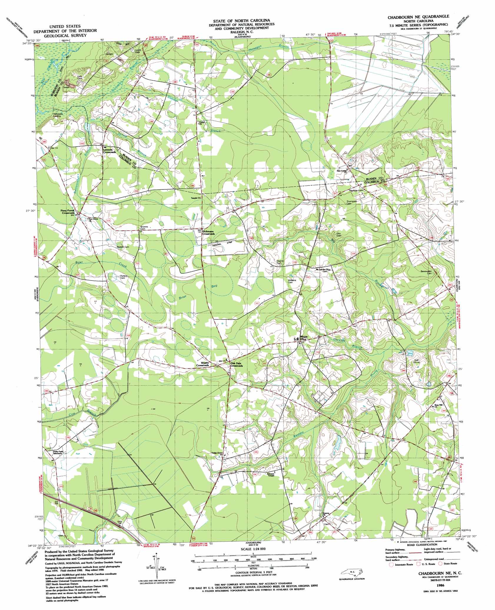
Chadbourn Ne Topo Map North Carolina
To zoom in, hover over the map of Chadbourn Ne
USGS Topo Quad 34078d7 - 1:24,000 scale
| Topo Map Name: | Chadbourn Ne |
| USGS Topo Quad ID: | 34078d7 |
| Print Size: | ca. 21 1/4" wide x 27" high |
| Southeast Coordinates: | 34.375° N latitude / 78.75° W longitude |
| Map Center Coordinates: | 34.4375° N latitude / 78.8125° W longitude |
| U.S. State: | NC |
| Filename: | o34078d7.jpg |
| Download Map JPG Image: | Chadbourn Ne topo map 1:24,000 scale |
| Map Type: | Topographic |
| Topo Series: | 7.5´ |
| Map Scale: | 1:24,000 |
| Source of Map Images: | United States Geological Survey (USGS) |
| Alternate Map Versions: |
Chadbourn NE NC 1986, updated 1987 Download PDF Buy paper map Chadbourn NE NC 2010 Download PDF Buy paper map Chadbourn NE NC 2013 Download PDF Buy paper map Chadbourn NE NC 2016 Download PDF Buy paper map |
1:24,000 Topo Quads surrounding Chadbourn Ne
Northwest Lumberton |
Northeast Lumberton |
Tar Heel |
Dublin |
Elizabethtown North |
Southwest Lumberton |
Southeast Lumberton |
Bladenboro |
Abbottsburg |
Elizabethtown South |
Fairmont |
Evergreen |
Chadbourn Ne |
Clarkton |
Emerson |
Fair Bluff |
Cerro Gordo |
Chadbourn |
Whiteville |
Lake Waccamaw West |
Duford |
Tabor City West |
Tabor City East |
Nakina |
Old Dock |
> Back to 34078a1 at 1:100,000 scale
> Back to 34078a1 at 1:250,000 scale
> Back to U.S. Topo Maps home
Chadbourn Ne topo map: Gazetteer
Chadbourn Ne: Flats
Brier Bay elevation 36m 118′Button Bay elevation 31m 101′
Rough Horn Bay elevation 31m 101′
Chadbourn Ne: Populated Places
Hickmans Crossroads elevation 35m 114′Lennons Crossroads elevation 32m 104′
Mount Olive elevation 31m 101′
Oak Dale Crossroads elevation 35m 114′
Piney Forest Crossroads elevation 32m 104′
Williams Cross Roads (historical) elevation 35m 114′
Wyatts Crossroads elevation 35m 114′
Chadbourn Ne: Streams
Big Branch elevation 21m 68′Greenes Branch elevation 22m 72′
Horsepen Branch elevation 27m 88′
Rattlesnake Branch elevation 26m 85′
Slender Branch elevation 28m 91′
Spring Branch elevation 31m 101′
Chadbourn Ne: Swamps
Beaver Dam Bay elevation 34m 111′Brown Morse Swamp elevation 34m 111′
Cow Bay elevation 31m 101′
Flat Bay elevation 32m 104′
Horsepen Swamp elevation 34m 111′
Slender Bay elevation 34m 111′
Chadbourn Ne digital topo map on disk
Buy this Chadbourn Ne topo map showing relief, roads, GPS coordinates and other geographical features, as a high-resolution digital map file on DVD:
South Carolina, Western North Carolina & Northeastern Georgia
Buy digital topo maps: South Carolina, Western North Carolina & Northeastern Georgia