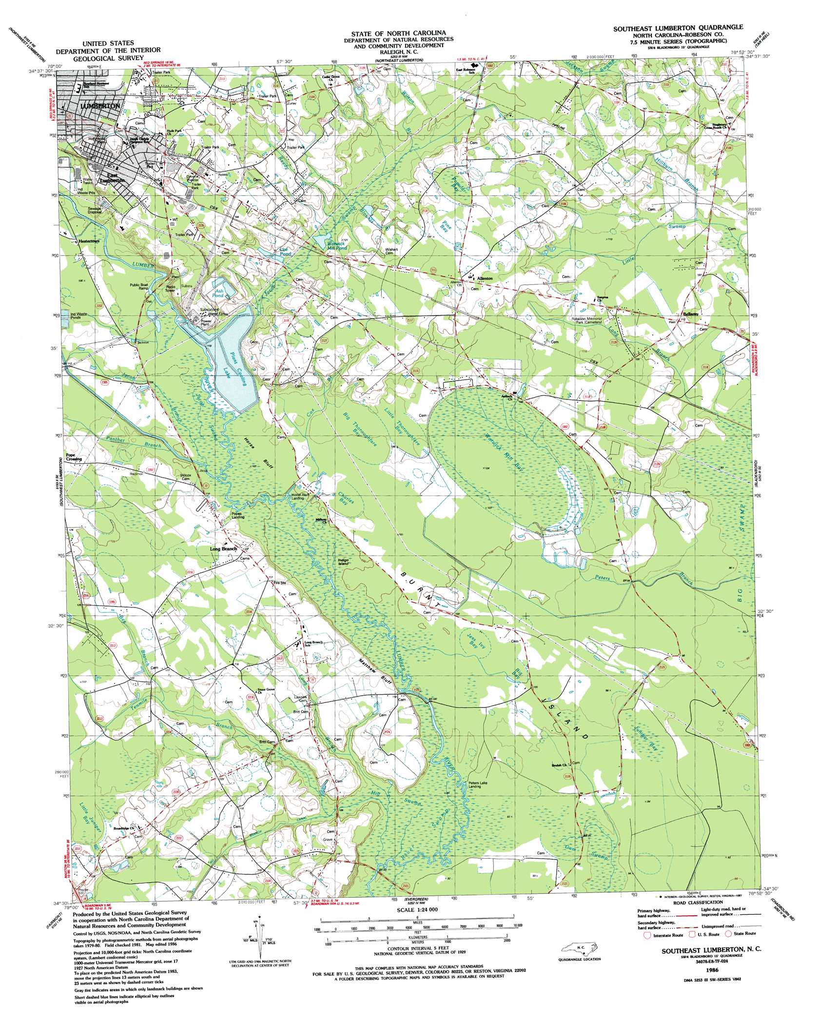
Southeast Lumberton Topo Map North Carolina
To zoom in, hover over the map of Southeast Lumberton
USGS Topo Quad 34078e8 - 1:24,000 scale
| Topo Map Name: | Southeast Lumberton |
| USGS Topo Quad ID: | 34078e8 |
| Print Size: | ca. 21 1/4" wide x 27" high |
| Southeast Coordinates: | 34.5° N latitude / 78.875° W longitude |
| Map Center Coordinates: | 34.5625° N latitude / 78.9375° W longitude |
| U.S. State: | NC |
| Filename: | o34078e8.jpg |
| Download Map JPG Image: | Southeast Lumberton topo map 1:24,000 scale |
| Map Type: | Topographic |
| Topo Series: | 7.5´ |
| Map Scale: | 1:24,000 |
| Source of Map Images: | United States Geological Survey (USGS) |
| Alternate Map Versions: |
Southeast Lumberton NC 1986, updated 1987 Download PDF Buy paper map Southeast Lumberton NC 1997, updated 2000 Download PDF Buy paper map Southeast Lumberton NC 2010 Download PDF Buy paper map Southeast Lumberton NC 2013 Download PDF Buy paper map Southeast Lumberton NC 2016 Download PDF Buy paper map |
1:24,000 Topo Quads surrounding Southeast Lumberton
Red Springs |
Rennert |
Saint Pauls |
Duart |
Jerome |
Pembroke |
Northwest Lumberton |
Northeast Lumberton |
Tar Heel |
Dublin |
Mcdonald |
Southwest Lumberton |
Southeast Lumberton |
Bladenboro |
Abbottsburg |
Gaddysville |
Fairmont |
Evergreen |
Chadbourn Ne |
Clarkton |
Lake View |
Fair Bluff |
Cerro Gordo |
Chadbourn |
Whiteville |
> Back to 34078e1 at 1:100,000 scale
> Back to 34078a1 at 1:250,000 scale
> Back to U.S. Topo Maps home
Southeast Lumberton topo map: Gazetteer
Southeast Lumberton: Basins
Big Bay elevation 29m 95′Big Thoroughfare Bay elevation 32m 104′
Charles Bay elevation 31m 101′
Jess Ivy Bay elevation 31m 101′
Juniper Bay elevation 28m 91′
Little Thoroughfare Bay elevation 31m 101′
Pine Bay elevation 41m 134′
Popular Bay elevation 41m 134′
Warwick Mill Bay elevation 32m 104′
Southeast Lumberton: Bays
Bear Bay elevation 33m 108′Southeast Lumberton: Canals
Big Branch Canal elevation 31m 101′Southeast Lumberton: Cliffs
Matthew Bluff elevation 33m 108′Southeast Lumberton: Dams
Cooling Lake Dam elevation 32m 104′Southeast Lumberton: Flats
Horse Bluff elevation 31m 101′Southeast Lumberton: Islands
Burnt Island elevation 30m 98′Indigo Island elevation 30m 98′
Southeast Lumberton: Populated Places
Allenton elevation 41m 134′Bellamy elevation 34m 111′
Country Side Mobile Home Park elevation 45m 147′
East Lumberton elevation 42m 137′
Hestertown elevation 34m 111′
Long Branch elevation 37m 121′
Phillips Mobile Home Park elevation 40m 131′
Pope Crossing elevation 36m 118′
West Mobile Home Park elevation 47m 154′
Southeast Lumberton: Reservoirs
Ash Pond elevation 42m 137′Cooling Lake elevation 32m 104′
Lee Pond elevation 35m 114′
Lennon Pond elevation 31m 101′
Plant Cooling Lake elevation 34m 111′
Warwick Mill Pond elevation 35m 114′
Southeast Lumberton: Streams
Bee Branch elevation 33m 108′Blounts Branch elevation 35m 114′
Cox Branch elevation 31m 101′
Hillburn Branch elevation 31m 101′
Jacob Branch elevation 31m 101′
Jacob Swamp elevation 32m 104′
Long Branch elevation 27m 88′
Long Branch elevation 29m 95′
Long Branch elevation 27m 88′
Panther Branch elevation 32m 104′
Peters Branch elevation 27m 88′
Reedy Branch elevation 35m 114′
Tenmile Branch elevation 29m 95′
Wilson Branch elevation 36m 118′
Southeast Lumberton: Swamps
Blounts Bay elevation 40m 131′Bog Bay elevation 30m 98′
Cypress Bay elevation 27m 88′
Gabriel Bay elevation 30m 98′
Gum Swamp elevation 27m 88′
Jacob Swamp elevation 31m 101′
Little Juniper Bay elevation 37m 121′
Mill Swamp elevation 28m 91′
Panther Bay elevation 41m 134′
Peters Swamp elevation 30m 98′
Pigeon Bay elevation 27m 88′
Pinks Bay elevation 41m 134′
River Swamp elevation 28m 91′
Thorofare Swamp elevation 32m 104′
Southeast Lumberton digital topo map on disk
Buy this Southeast Lumberton topo map showing relief, roads, GPS coordinates and other geographical features, as a high-resolution digital map file on DVD:
South Carolina, Western North Carolina & Northeastern Georgia
Buy digital topo maps: South Carolina, Western North Carolina & Northeastern Georgia