Ingold Topo Map North Carolina
To zoom in, hover over the map of Ingold
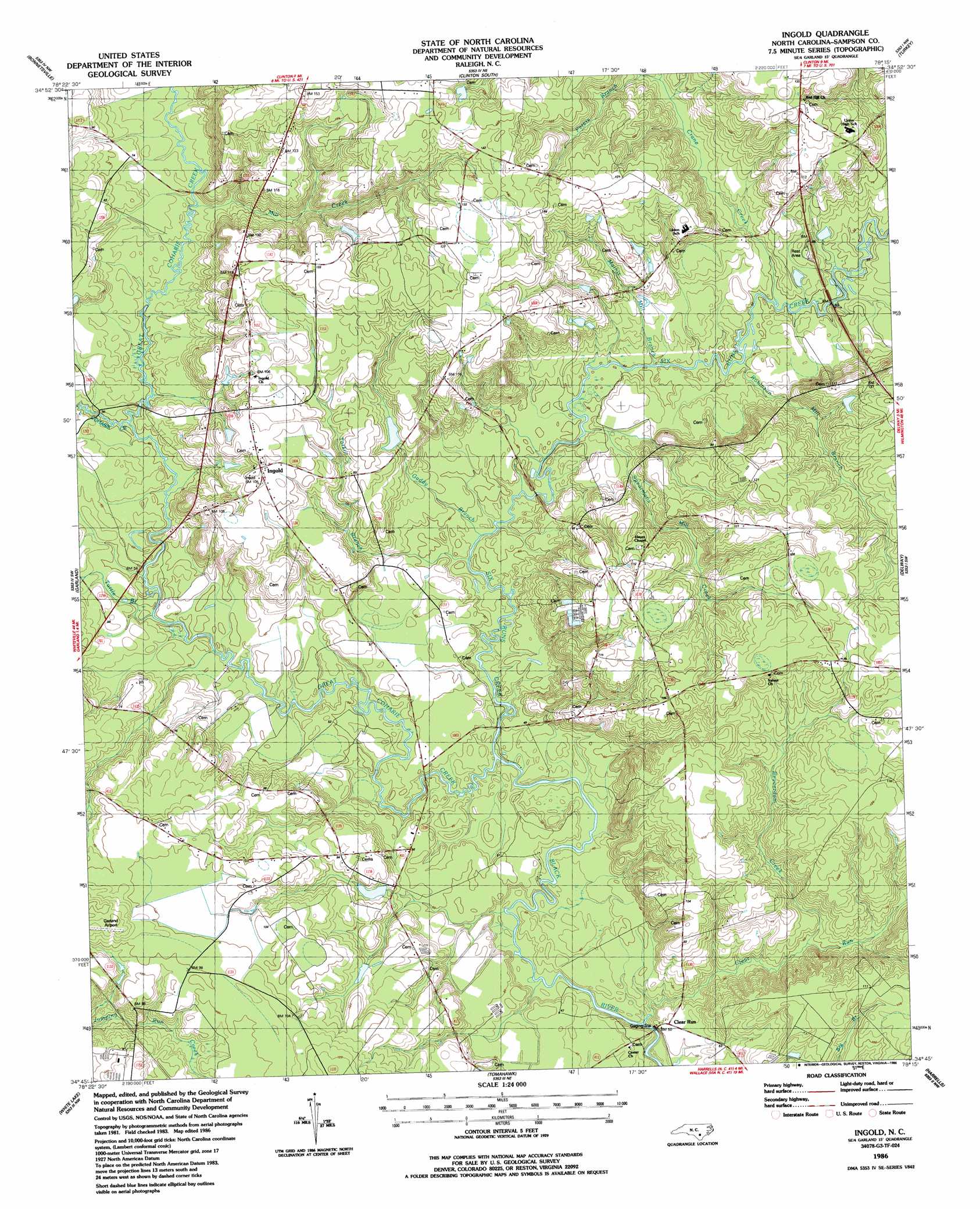
USGS Topo Quad 34078g3 - 1:24,000 scale
| Topo Map Name: | Ingold |
| USGS Topo Quad ID: | 34078g3 |
| Print Size: | ca. 21 1/4" wide x 27" high |
| Southeast Coordinates: | 34.75° N latitude / 78.25° W longitude |
| Map Center Coordinates: | 34.8125° N latitude / 78.3125° W longitude |
| U.S. State: | NC |
| Filename: | o34078g3.jpg |
| Download Map JPG Image: | Ingold topo map 1:24,000 scale |
| Map Type: | Topographic |
| Topo Series: | 7.5´ |
| Map Scale: | 1:24,000 |
| Source of Map Images: | United States Geological Survey (USGS) |
| Alternate Map Versions: |
Ingold NC 1986, updated 1986 Download PDF Buy paper map Ingold NC 2010 Download PDF Buy paper map Ingold NC 2013 Download PDF Buy paper map Ingold NC 2016 Download PDF Buy paper map |
1:24,000 Topo Quads surrounding Ingold
Salemburg |
Bearskin |
Clinton North |
Faison |
Warsaw North |
Roseboro |
Bonnetsville |
Clinton South |
Turkey |
Warsaw South |
Ammon |
Garland |
Ingold |
Delway |
Rose Hill |
Elizabethtown North |
White Lake |
Tomahawk |
Harrells |
Wallace West |
Elizabethtown South |
Singletary Lake |
Rowan |
Atkinson |
Costin |
> Back to 34078e1 at 1:100,000 scale
> Back to 34078a1 at 1:250,000 scale
> Back to U.S. Topo Maps home
Ingold topo map: Gazetteer
Ingold: Airports
Garland Airport elevation 35m 114′Ingold: Populated Places
Clear Run elevation 15m 49′Ingold elevation 30m 98′
Ingold: Streams
Beaverdam Creek elevation 16m 52′Bills Swamp elevation 15m 49′
Buckhorn Creek elevation 20m 65′
Clear Run elevation 10m 32′
Crane Creek elevation 16m 52′
Gaddy Branch elevation 13m 42′
Great Coharie Creek elevation 11m 36′
Little Coharie Creek elevation 15m 49′
Mathis Mill Branch elevation 16m 52′
Mill Creek elevation 18m 59′
Peters Branch elevation 21m 68′
Robinson Mill Branch elevation 15m 49′
Six Runs Creek elevation 11m 36′
Spearmans Mill Creek elevation 14m 45′
Tarkill Branch elevation 13m 42′
Turtle Branch elevation 16m 52′
Ingold: Swamps
Hog Island Swamp elevation 30m 98′Ingold digital topo map on disk
Buy this Ingold topo map showing relief, roads, GPS coordinates and other geographical features, as a high-resolution digital map file on DVD:
South Carolina, Western North Carolina & Northeastern Georgia
Buy digital topo maps: South Carolina, Western North Carolina & Northeastern Georgia