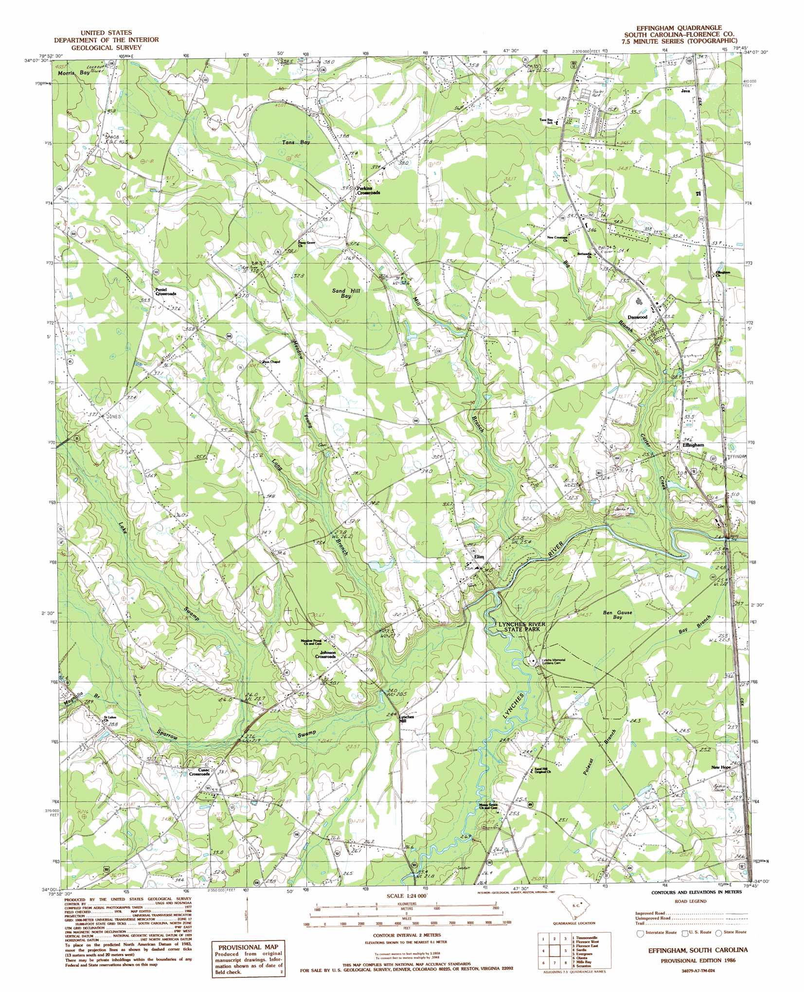
Effingham Topo Map South Carolina
To zoom in, hover over the map of Effingham
USGS Topo Quad 34079a7 - 1:24,000 scale
| Topo Map Name: | Effingham |
| USGS Topo Quad ID: | 34079a7 |
| Print Size: | ca. 21 1/4" wide x 27" high |
| Southeast Coordinates: | 34° N latitude / 79.75° W longitude |
| Map Center Coordinates: | 34.0625° N latitude / 79.8125° W longitude |
| U.S. State: | SC |
| Filename: | o34079a7.jpg |
| Download Map JPG Image: | Effingham topo map 1:24,000 scale |
| Map Type: | Topographic |
| Topo Series: | 7.5´ |
| Map Scale: | 1:24,000 |
| Source of Map Images: | United States Geological Survey (USGS) |
| Alternate Map Versions: |
Effingham SC 1986, updated 1987 Download PDF Buy paper map Effingham SC 2011 Download PDF Buy paper map Effingham SC 2014 Download PDF Buy paper map |
1:24,000 Topo Quads surrounding Effingham
Hartsville South |
Darlington West |
Darlington East |
Witherspoon Island |
Oak Grove |
Lamar |
Timmonsville |
Florence West |
Florence East |
Pee Dee |
Lynchburg |
Sardis |
Effingham |
Evergreen |
Pamplico North |
Turbeville |
Olanta |
Mill Bay |
Scranton |
Pamplico South |
Sardinia |
Hebron Crossroads |
Lake City West |
Lake City East |
Prospect Crossroads |
> Back to 34079a1 at 1:100,000 scale
> Back to 34078a1 at 1:250,000 scale
> Back to U.S. Topo Maps home
Effingham topo map: Gazetteer
Effingham: Basins
Sand Hill Bay elevation 36m 118′Whites Bay elevation 35m 114′
Effingham: Crossings
Old Saw Mill Ferry (historical) elevation 21m 68′Effingham: Dams
Blackwell Pond Dam D-3569 elevation 26m 85′Effingham: Parks
Lynches River State Park elevation 24m 78′Effingham: Populated Places
Cusac Crossroads elevation 32m 104′Danwood elevation 33m 108′
Effingham elevation 30m 98′
Elim elevation 33m 108′
Hamville (historical) elevation 32m 104′
Java elevation 36m 118′
Johnson Crossroads elevation 32m 104′
Jones Crossroads elevation 37m 121′
Lynches Mill elevation 24m 78′
New Hope elevation 24m 78′
Peniel Crossroads elevation 38m 124′
Perkins Crossroads elevation 37m 121′
Effingham: Post Offices
Effingham Post Office elevation 34m 111′Effingham: Reservoirs
Blackwell Pond elevation 26m 85′Effingham: Streams
Bay Branch elevation 21m 68′Big Branch elevation 29m 95′
Carter Creek elevation 20m 65′
Lake Swamp elevation 22m 72′
Little Bay Branch elevation 22m 72′
Long Branch elevation 21m 68′
Magnolia Branch elevation 26m 85′
Meadow Prong elevation 27m 88′
Mill Branch elevation 20m 65′
Polecat Branch elevation 24m 78′
Sparrow Swamp elevation 21m 68′
Effingham: Swamps
Ben Gause Bay elevation 24m 78′Tans Bay elevation 37m 121′
Effingham digital topo map on disk
Buy this Effingham topo map showing relief, roads, GPS coordinates and other geographical features, as a high-resolution digital map file on DVD:
South Carolina, Western North Carolina & Northeastern Georgia
Buy digital topo maps: South Carolina, Western North Carolina & Northeastern Georgia