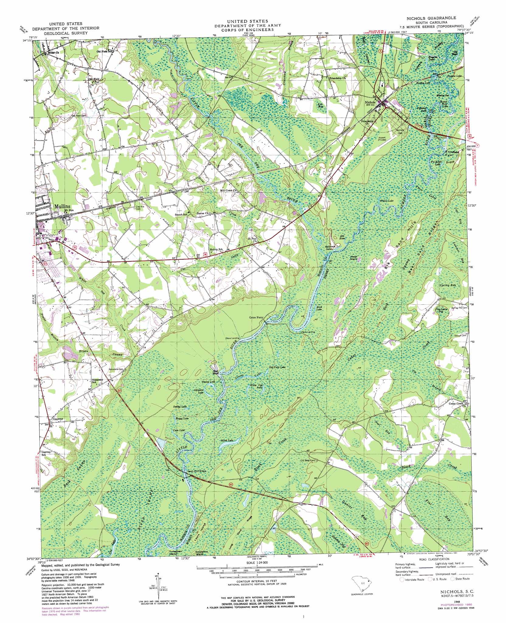
Nichols Topo Map South Carolina
To zoom in, hover over the map of Nichols
USGS Topo Quad 34079b2 - 1:24,000 scale
| Topo Map Name: | Nichols |
| USGS Topo Quad ID: | 34079b2 |
| Print Size: | ca. 21 1/4" wide x 27" high |
| Southeast Coordinates: | 34.125° N latitude / 79.125° W longitude |
| Map Center Coordinates: | 34.1875° N latitude / 79.1875° W longitude |
| U.S. State: | SC |
| Filename: | o34079b2.jpg |
| Download Map JPG Image: | Nichols topo map 1:24,000 scale |
| Map Type: | Topographic |
| Topo Series: | 7.5´ |
| Map Scale: | 1:24,000 |
| Source of Map Images: | United States Geological Survey (USGS) |
| Alternate Map Versions: |
Nichols SC 1948, updated 1981 Download PDF Buy paper map Nichols SC 1950 Download PDF Buy paper map Nichols SC 2011 Download PDF Buy paper map Nichols SC 2014 Download PDF Buy paper map |
1:24,000 Topo Quads surrounding Nichols
Dillon West |
Dillon East |
Gaddysville |
Fairmont |
Evergreen |
Latta |
Fork |
Lake View |
Fair Bluff |
Cerro Gordo |
Marion |
Mullins |
Nichols |
Duford |
Tabor City West |
Friendship |
Centenary |
Galivants Ferry |
Bayboro |
Loris |
Gresham |
Britton Neck |
Horry |
Adrian |
Shell |
> Back to 34079a1 at 1:100,000 scale
> Back to 34078a1 at 1:250,000 scale
> Back to U.S. Topo Maps home
Nichols topo map: Gazetteer
Nichols: Bays
Rice Field Cove elevation 14m 45′Nichols: Bends
Worly Cut elevation 14m 45′Nichols: Bridges
Nichols Bridge (historical) elevation 14m 45′Sandy Bluff Bridge elevation 12m 39′
Nichols: Cliffs
Red Bluff elevation 12m 39′Nichols: Crossings
Floyds Ferry (historical) elevation 14m 45′Grices Ferry (historical) elevation 12m 39′
Newsons Ferry (historical) elevation 14m 45′
Nichols: Dams
McMillen Lower Pond Dam D-0515 elevation 20m 65′McMillen Upper Pond Dam D-0514 elevation 23m 75′
Stroud Pond Dam D-3612 elevation 16m 52′
Nichols: Guts
Black Creek elevation 13m 42′Nichols: Islands
Grapevine Island elevation 12m 39′Hawk Island elevation 14m 45′
Lewis Island elevation 14m 45′
Turkeypen Island elevation 12m 39′
Nichols: Lakes
Alligator Lake elevation 13m 42′Anderson Lake elevation 14m 45′
Boggy Lake elevation 12m 39′
Brushy Lake elevation 14m 45′
Cain Lake elevation 11m 36′
Cox Lake elevation 11m 36′
Fishtrap Lake elevation 14m 45′
Grassy Lake elevation 13m 42′
Huggins Lake elevation 14m 45′
Mash Lake elevation 11m 36′
Old Field Lake elevation 13m 42′
Old River elevation 14m 45′
Old River elevation 14m 45′
Pitch Lake elevation 14m 45′
Rech Lake elevation 13m 42′
Round Hole Lake elevation 14m 45′
Shaley Lake elevation 13m 42′
Smoky Lake elevation 13m 42′
Vol Rowll Lake elevation 15m 49′
White Oak Lake elevation 13m 42′
Widow Lake elevation 15m 49′
Nichols: Populated Places
Gapway elevation 30m 98′Nichols elevation 17m 55′
Pitch Landing elevation 14m 45′
Stave Landing elevation 12m 39′
Nichols: Post Offices
Nichols Post Office elevation 16m 52′Nichols: Reservoirs
Stroud Pond elevation 16m 52′Nichols: Ridges
Bear Sand Ridges elevation 15m 49′Long Sand Ridge elevation 13m 42′
Nichols: Streams
Boggy Branch elevation 15m 49′Briar Creek elevation 14m 45′
Brown Swamp elevation 12m 39′
Cedar Creek elevation 12m 39′
Crutchlow Branch elevation 18m 59′
Fowler Branch elevation 21m 68′
Jet Branch elevation 14m 45′
Lumber River elevation 13m 42′
The Gully elevation 17m 55′
White Oak Creek elevation 14m 45′
Nichols: Summits
Big Sand Hills elevation 15m 49′Nichols: Swamps
Back Swamp elevation 14m 45′Cow Bog elevation 16m 52′
Crosstie Lake elevation 14m 45′
Flat Bay elevation 20m 65′
Fox Bay elevation 26m 85′
Gunter Bay elevation 18m 59′
Hannah Bay elevation 18m 59′
Jim Lewis Bay elevation 15m 49′
Juniper Bay elevation 17m 55′
Noel Bay elevation 17m 55′
River Swamp elevation 12m 39′
Spring Bay elevation 17m 55′
Three Lakes elevation 15m 49′
Nichols digital topo map on disk
Buy this Nichols topo map showing relief, roads, GPS coordinates and other geographical features, as a high-resolution digital map file on DVD:
South Carolina, Western North Carolina & Northeastern Georgia
Buy digital topo maps: South Carolina, Western North Carolina & Northeastern Georgia