Laurinburg Topo Map North Carolina
To zoom in, hover over the map of Laurinburg
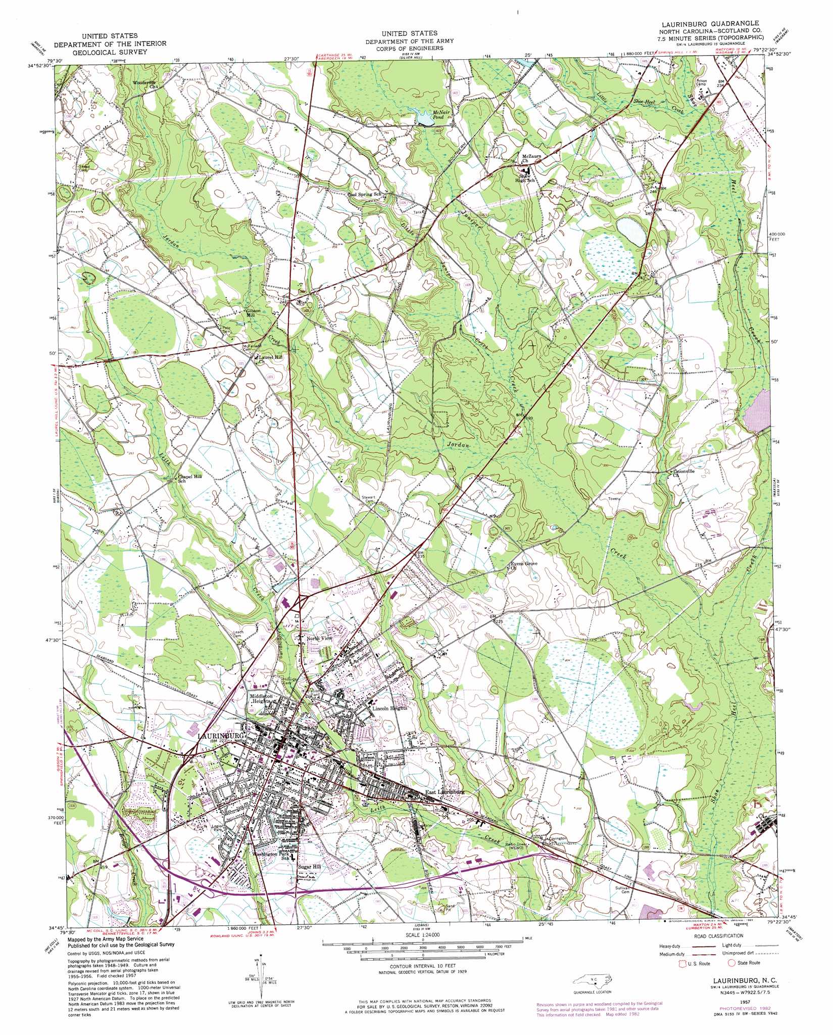
USGS Topo Quad 34079g4 - 1:24,000 scale
| Topo Map Name: | Laurinburg |
| USGS Topo Quad ID: | 34079g4 |
| Print Size: | ca. 21 1/4" wide x 27" high |
| Southeast Coordinates: | 34.75° N latitude / 79.375° W longitude |
| Map Center Coordinates: | 34.8125° N latitude / 79.4375° W longitude |
| U.S. State: | NC |
| Filename: | o34079g4.jpg |
| Download Map JPG Image: | Laurinburg topo map 1:24,000 scale |
| Map Type: | Topographic |
| Topo Series: | 7.5´ |
| Map Scale: | 1:24,000 |
| Source of Map Images: | United States Geological Survey (USGS) |
| Alternate Map Versions: |
Laurinburg NC 1949, updated 1953 Download PDF Buy paper map Laurinburg NC 1957, updated 1960 Download PDF Buy paper map Laurinburg NC 1957, updated 1983 Download PDF Buy paper map Laurinburg NC 1976, updated 1978 Download PDF Buy paper map Laurinburg NC 2010 Download PDF Buy paper map Laurinburg NC 2013 Download PDF Buy paper map Laurinburg NC 2016 Download PDF Buy paper map |
1:24,000 Topo Quads surrounding Laurinburg
Millstone Lake |
Hoffman |
Pinebluff |
Mccain |
Nicholson Creek |
Hamlet |
Marston |
Silver Hill |
Wagram |
Raeford |
Ghio |
Gibson |
Laurinburg |
Wakulla |
Red Springs |
Bennettsville North |
Mccoll |
Johns |
Maxton |
Pembroke |
Bennettsville South |
Clio |
Minturn |
Rowland |
Mcdonald |
> Back to 34079e1 at 1:100,000 scale
> Back to 34078a1 at 1:250,000 scale
> Back to U.S. Topo Maps home
Laurinburg topo map: Gazetteer
Laurinburg: Dams
Jones Pond Dam elevation 62m 203′Laurinburg: Parks
Pate Stadium elevation 69m 226′Laurinburg: Populated Places
Bel Air elevation 68m 223′Carolina Park elevation 68m 223′
College Park North elevation 68m 223′
College Park South elevation 65m 213′
East Laurinburg elevation 65m 213′
Gibson Mill elevation 69m 226′
Glen Acres elevation 66m 216′
Glynn Fields elevation 68m 223′
Hammon Heights elevation 66m 216′
Langley Place elevation 67m 219′
Langley Place Mobile Home Park elevation 69m 226′
Laurinburg elevation 68m 223′
Lincoln Heights elevation 69m 226′
McBryde Farm elevation 64m 209′
McLaurin Acres elevation 70m 229′
Middleton Heights elevation 70m 229′
Norman Heights elevation 68m 223′
North View elevation 70m 229′
Park Wood elevation 69m 226′
Scottsdale elevation 68m 223′
Stewartville Acres elevation 66m 216′
Sugar Hill elevation 66m 216′
Sunshine Park elevation 66m 216′
Tara Acres elevation 69m 226′
Westland Forest elevation 68m 223′
Westwood elevation 68m 223′
Laurinburg: Reservoirs
Jones Pond elevation 62m 203′McCormick Pond elevation 56m 183′
McNair Fishpond elevation 56m 183′
McNair Pond elevation 67m 219′
Laurinburg: Streams
Baidge Creek elevation 58m 190′Jordan Creek elevation 53m 173′
Juniper Creek elevation 58m 190′
Little Juniper Creek elevation 59m 193′
Little Shoe Heel Creek elevation 65m 213′
Laurinburg digital topo map on disk
Buy this Laurinburg topo map showing relief, roads, GPS coordinates and other geographical features, as a high-resolution digital map file on DVD:
South Carolina, Western North Carolina & Northeastern Georgia
Buy digital topo maps: South Carolina, Western North Carolina & Northeastern Georgia