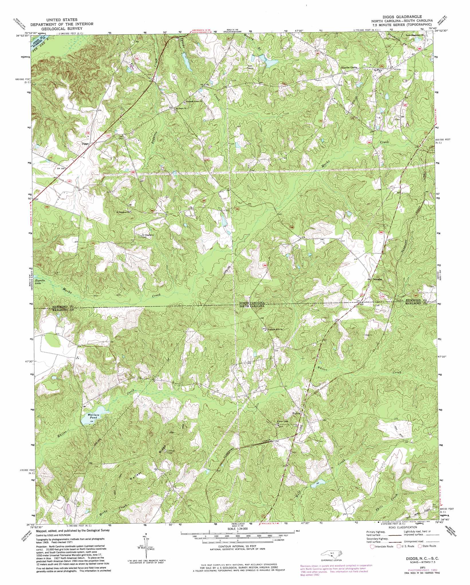
Diggs Topo Map North Carolina
To zoom in, hover over the map of Diggs
USGS Topo Quad 34079g7 - 1:24,000 scale
| Topo Map Name: | Diggs |
| USGS Topo Quad ID: | 34079g7 |
| Print Size: | ca. 21 1/4" wide x 27" high |
| Southeast Coordinates: | 34.75° N latitude / 79.75° W longitude |
| Map Center Coordinates: | 34.8125° N latitude / 79.8125° W longitude |
| U.S. States: | NC, SC |
| Filename: | o34079g7.jpg |
| Download Map JPG Image: | Diggs topo map 1:24,000 scale |
| Map Type: | Topographic |
| Topo Series: | 7.5´ |
| Map Scale: | 1:24,000 |
| Source of Map Images: | United States Geological Survey (USGS) |
| Alternate Map Versions: |
Diggs NC 1971, updated 1973 Download PDF Buy paper map Diggs NC 1971, updated 1983 Download PDF Buy paper map Diggs NC 1976, updated 1978 Download PDF Buy paper map Diggs NC 2011 Download PDF Buy paper map Diggs NC 2013 Download PDF Buy paper map Diggs NC 2016 Download PDF Buy paper map |
1:24,000 Topo Quads surrounding Diggs
Ansonville |
Mangum |
Ellerbe |
Millstone Lake |
Hoffman |
Wadesboro |
Lilesville |
Rockingham |
Hamlet |
Marston |
Morven West |
Morven East |
Diggs |
Ghio |
Gibson |
Chesterfield |
Cheraw |
Wallace |
Bennettsville North |
Mccoll |
Patrick |
Cash |
Society Hill |
Bennettsville South |
Clio |
> Back to 34079e1 at 1:100,000 scale
> Back to 34078a1 at 1:250,000 scale
> Back to U.S. Topo Maps home
Diggs topo map: Gazetteer
Diggs: Dams
Haire Pond Dam D-3431 elevation 49m 160′South Carolina Noname 35001 D-3426 Dam elevation 38m 124′
Wall Pond Dam elevation 55m 180′
Diggs: Populated Places
Diggs elevation 110m 360′Ellerbe Grove elevation 100m 328′
Fulton elevation 67m 219′
Little Mountain (historical) elevation 94m 308′
Osborne elevation 90m 295′
Diggs: Reservoirs
Everette Mill Pond elevation 38m 124′Gillespies Pond (historical) elevation 41m 134′
Haire Pond elevation 49m 160′
Wall Pond elevation 55m 180′
Wallace Pond elevation 38m 124′
Diggs: Ridges
Ballast Ridge elevation 107m 351′Diggs digital topo map on disk
Buy this Diggs topo map showing relief, roads, GPS coordinates and other geographical features, as a high-resolution digital map file on DVD:
South Carolina, Western North Carolina & Northeastern Georgia
Buy digital topo maps: South Carolina, Western North Carolina & Northeastern Georgia