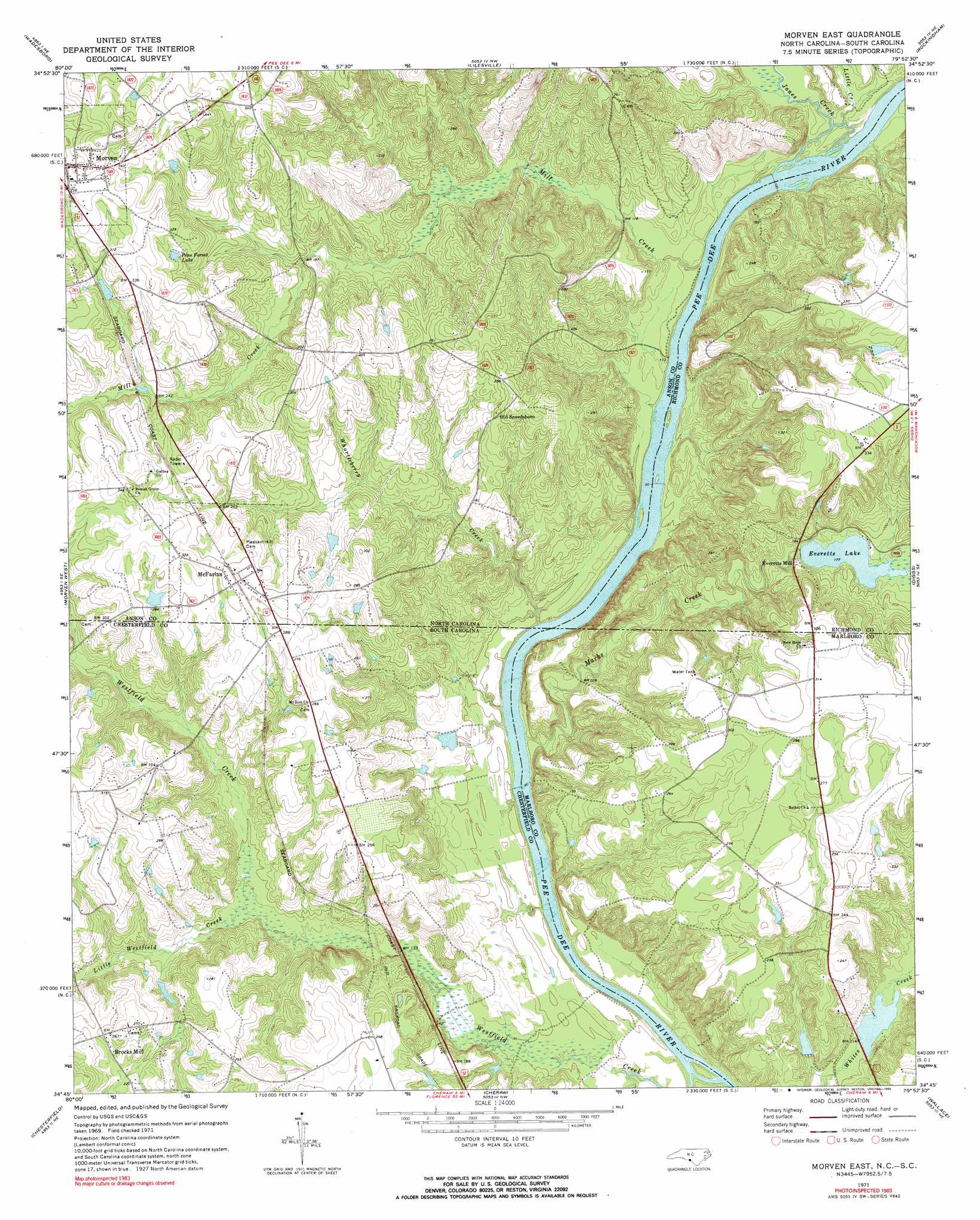
Morven East Topo Map North Carolina
To zoom in, hover over the map of Morven East
USGS Topo Quad 34079g8 - 1:24,000 scale
| Topo Map Name: | Morven East |
| USGS Topo Quad ID: | 34079g8 |
| Print Size: | ca. 21 1/4" wide x 27" high |
| Southeast Coordinates: | 34.75° N latitude / 79.875° W longitude |
| Map Center Coordinates: | 34.8125° N latitude / 79.9375° W longitude |
| U.S. States: | NC, SC |
| Filename: | o34079g8.jpg |
| Download Map JPG Image: | Morven East topo map 1:24,000 scale |
| Map Type: | Topographic |
| Topo Series: | 7.5´ |
| Map Scale: | 1:24,000 |
| Source of Map Images: | United States Geological Survey (USGS) |
| Alternate Map Versions: |
Morven East NC 1971, updated 1973 Download PDF Buy paper map Morven East NC 1971, updated 1990 Download PDF Buy paper map Morven East NC 1976, updated 1978 Download PDF Buy paper map Morven East NC 2011 Download PDF Buy paper map Morven East NC 2013 Download PDF Buy paper map Morven East NC 2016 Download PDF Buy paper map |
1:24,000 Topo Quads surrounding Morven East
Polkton |
Ansonville |
Mangum |
Ellerbe |
Millstone Lake |
Russellville |
Wadesboro |
Lilesville |
Rockingham |
Hamlet |
Mount Croghan |
Morven West |
Morven East |
Diggs |
Ghio |
Ruby |
Chesterfield |
Cheraw |
Wallace |
Bennettsville North |
Middendorf |
Patrick |
Cash |
Society Hill |
Bennettsville South |
> Back to 34079e1 at 1:100,000 scale
> Back to 34078a1 at 1:250,000 scale
> Back to U.S. Topo Maps home
Morven East topo map: Gazetteer
Morven East: Crossings
Parkers Ferry (historical) elevation 24m 78′Morven East: Dams
Everett Lake Dam elevation 54m 177′Nelson Lake Dam elevation 70m 229′
Phillips Pond Dam D-3215 elevation 30m 98′
Pusser Pond Dam D-3425 elevation 73m 239′
South Carolina Noname 35015 Dam D-3427 elevation 32m 104′
Morven East: Falls
Gordons Falls elevation 22m 72′Morven East: Islands
Horse Island elevation 29m 95′Stag Rock elevation 24m 78′
Morven East: Populated Places
Brocks Mill elevation 79m 259′Everetts Mill elevation 58m 190′
Laneys (historical) elevation 63m 206′
McFarlan elevation 92m 301′
Old Sneedsboro elevation 78m 255′
Morven East: Reservoirs
Everetts Lake elevation 54m 177′Nelson Lake elevation 70m 229′
Paul Wallace Pond elevation 32m 104′
Pine Forest Lake elevation 90m 295′
Pusser Pond elevation 73m 239′
Morven East: Streams
Goodmans Creek elevation 26m 85′Jones Creek elevation 31m 101′
Little Creek elevation 34m 111′
Little Westfield Creek elevation 42m 137′
Marks Creek elevation 26m 85′
Marks Creek elevation 24m 78′
Mill Creek elevation 34m 111′
Whortleberry Creek elevation 28m 91′
Morven East digital topo map on disk
Buy this Morven East topo map showing relief, roads, GPS coordinates and other geographical features, as a high-resolution digital map file on DVD:
South Carolina, Western North Carolina & Northeastern Georgia
Buy digital topo maps: South Carolina, Western North Carolina & Northeastern Georgia