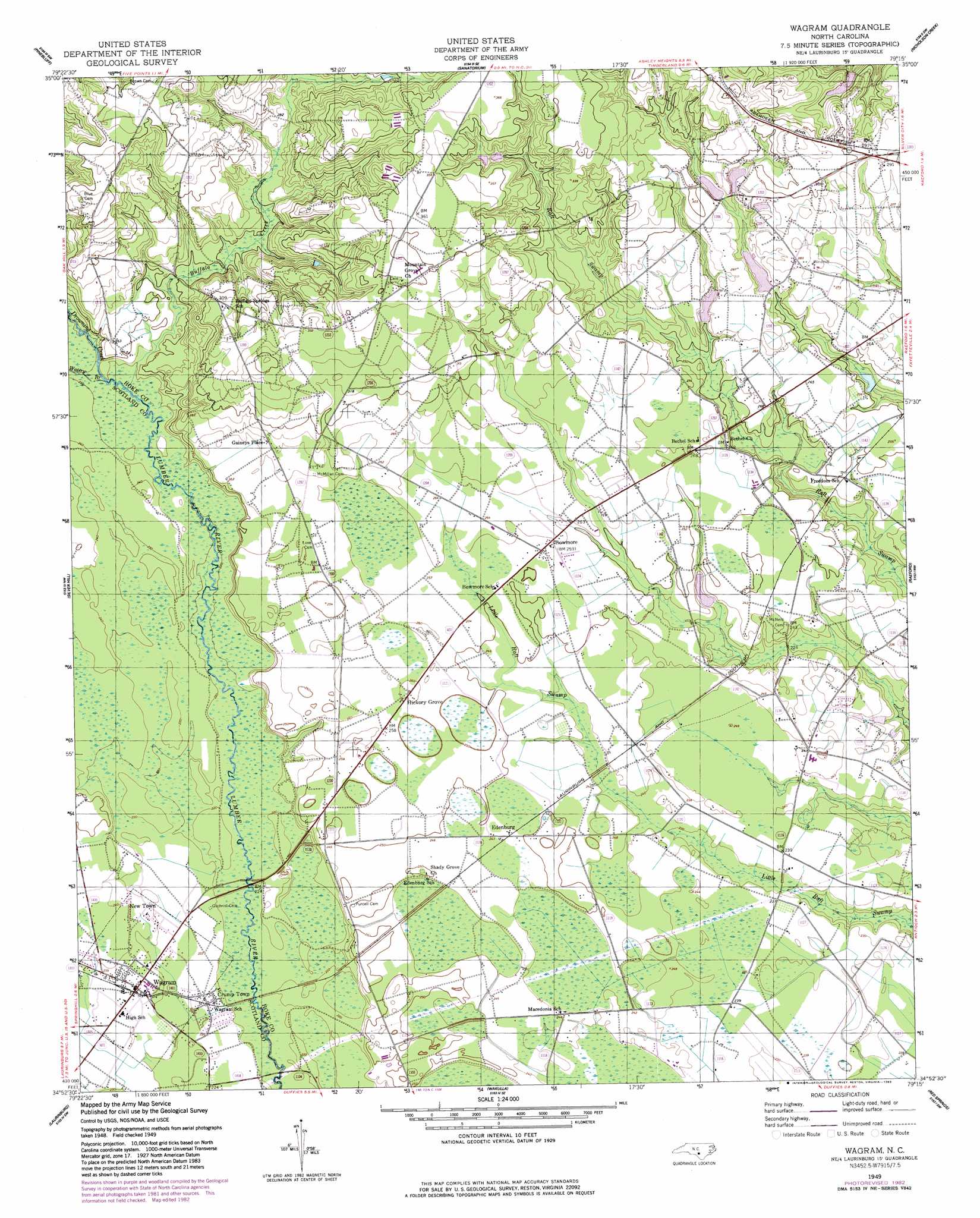
Wagram Topo Map North Carolina
To zoom in, hover over the map of Wagram
USGS Topo Quad 34079h3 - 1:24,000 scale
| Topo Map Name: | Wagram |
| USGS Topo Quad ID: | 34079h3 |
| Print Size: | ca. 21 1/4" wide x 27" high |
| Southeast Coordinates: | 34.875° N latitude / 79.25° W longitude |
| Map Center Coordinates: | 34.9375° N latitude / 79.3125° W longitude |
| U.S. State: | NC |
| Filename: | o34079h3.jpg |
| Download Map JPG Image: | Wagram topo map 1:24,000 scale |
| Map Type: | Topographic |
| Topo Series: | 7.5´ |
| Map Scale: | 1:24,000 |
| Source of Map Images: | United States Geological Survey (USGS) |
| Alternate Map Versions: |
Wagram NC 1949, updated 1953 Download PDF Buy paper map Wagram NC 1949, updated 1983 Download PDF Buy paper map Wagram NC 1976, updated 1978 Download PDF Buy paper map Wagram NC 2002, updated 2002 Download PDF Buy paper map Wagram NC 2010 Download PDF Buy paper map Wagram NC 2013 Download PDF Buy paper map Wagram NC 2016 Download PDF Buy paper map |
1:24,000 Topo Quads surrounding Wagram
West End |
Southern Pines |
Niagara |
Lobelia |
Overhills |
Hoffman |
Pinebluff |
Mccain |
Nicholson Creek |
Clifdale |
Marston |
Silver Hill |
Wagram |
Raeford |
Parkton |
Gibson |
Laurinburg |
Wakulla |
Red Springs |
Rennert |
Mccoll |
Johns |
Maxton |
Pembroke |
Northwest Lumberton |
> Back to 34079e1 at 1:100,000 scale
> Back to 34078a1 at 1:250,000 scale
> Back to U.S. Topo Maps home
Wagram topo map: Gazetteer
Wagram: Dams
Earl Hendrix Dam elevation 70m 229′Wrights Pond Dam elevation 81m 265′
Wagram: Populated Places
Bowmore elevation 79m 259′Crump Town elevation 69m 226′
Edinburgh elevation 75m 246′
Gaineys Place elevation 86m 282′
Hickory Grove elevation 80m 262′
New Town elevation 70m 229′
Wagram elevation 73m 239′
Wagram: Reservoirs
Wrights Pond elevation 81m 265′Wagram: Streams
Buffalo Creek elevation 70m 229′Drowning Creek elevation 70m 229′
Watery Branch elevation 70m 229′
Wagram digital topo map on disk
Buy this Wagram topo map showing relief, roads, GPS coordinates and other geographical features, as a high-resolution digital map file on DVD:
South Carolina, Western North Carolina & Northeastern Georgia
Buy digital topo maps: South Carolina, Western North Carolina & Northeastern Georgia