Hamlet Topo Map North Carolina
To zoom in, hover over the map of Hamlet
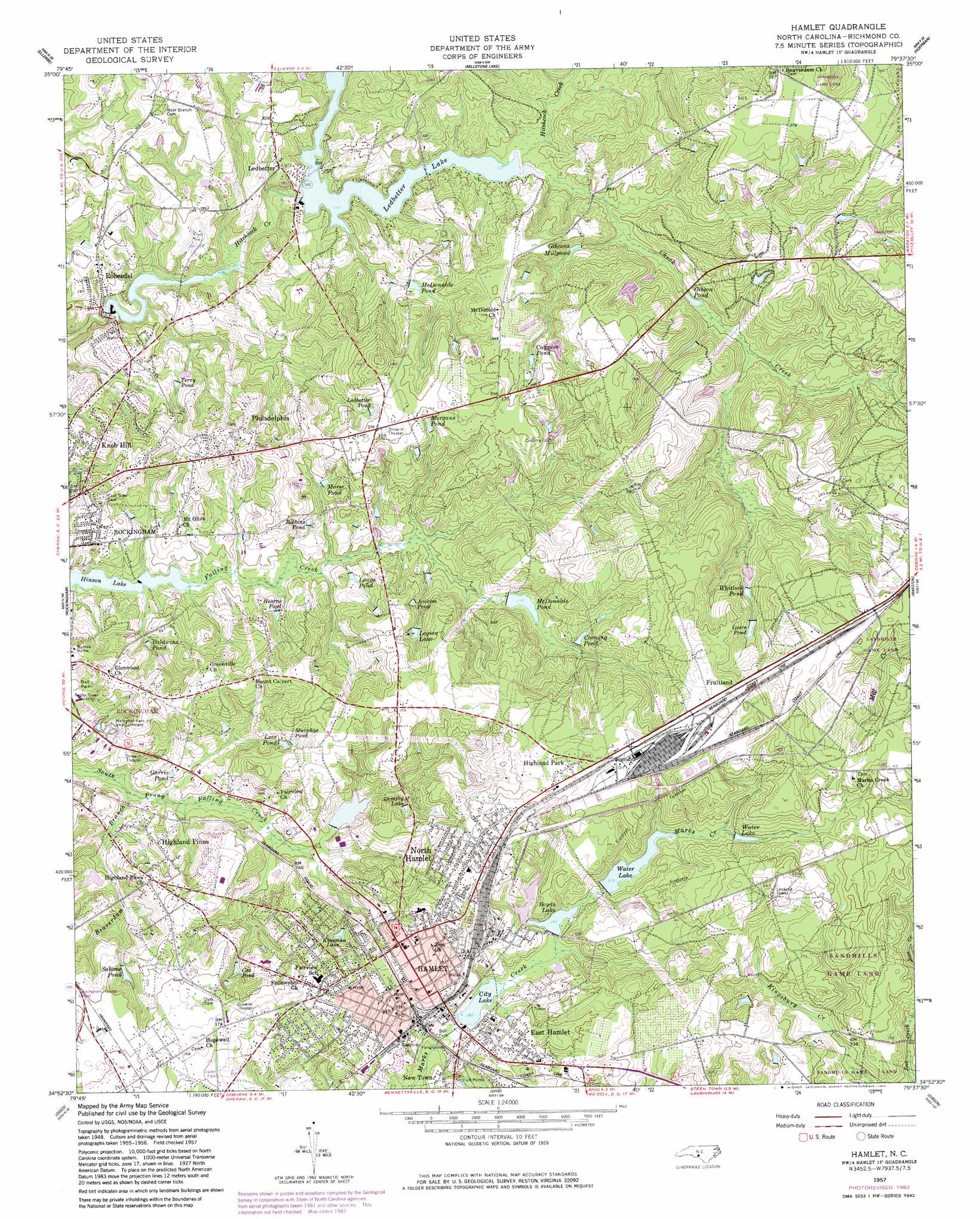
USGS Topo Quad 34079h6 - 1:24,000 scale
| Topo Map Name: | Hamlet |
| USGS Topo Quad ID: | 34079h6 |
| Print Size: | ca. 21 1/4" wide x 27" high |
| Southeast Coordinates: | 34.875° N latitude / 79.625° W longitude |
| Map Center Coordinates: | 34.9375° N latitude / 79.6875° W longitude |
| U.S. State: | NC |
| Filename: | o34079h6.jpg |
| Download Map JPG Image: | Hamlet topo map 1:24,000 scale |
| Map Type: | Topographic |
| Topo Series: | 7.5´ |
| Map Scale: | 1:24,000 |
| Source of Map Images: | United States Geological Survey (USGS) |
| Alternate Map Versions: |
Hamlet NC 1949, updated 1953 Download PDF Buy paper map Hamlet NC 1957, updated 1960 Download PDF Buy paper map Hamlet NC 1957, updated 1983 Download PDF Buy paper map Hamlet NC 1957, updated 1983 Download PDF Buy paper map Hamlet NC 1976, updated 1978 Download PDF Buy paper map Hamlet NC 2002, updated 2002 Download PDF Buy paper map Hamlet NC 2010 Download PDF Buy paper map Hamlet NC 2013 Download PDF Buy paper map Hamlet NC 2016 Download PDF Buy paper map |
1:24,000 Topo Quads surrounding Hamlet
Mount Gilead East |
Harrisville |
Norman |
West End |
Southern Pines |
Mangum |
Ellerbe |
Millstone Lake |
Hoffman |
Pinebluff |
Lilesville |
Rockingham |
Hamlet |
Marston |
Silver Hill |
Morven East |
Diggs |
Ghio |
Gibson |
Laurinburg |
Cheraw |
Wallace |
Bennettsville North |
Mccoll |
Johns |
> Back to 34079e1 at 1:100,000 scale
> Back to 34078a1 at 1:250,000 scale
> Back to U.S. Topo Maps home
Hamlet topo map: Gazetteer
Hamlet: Dams
Bland Pond Dam elevation 95m 311′Boyds Lake Dam elevation 88m 288′
Hamlet City Lake Dam elevation 86m 282′
Hamlet City Lake Upper Dam elevation 98m 321′
Hinson Pond Dam elevation 66m 216′
Ledbetter Lake Dam elevation 70m 229′
Richmond Technical Inst Lake Dam elevation 79m 259′
Roberdel Pond Dam elevation 70m 229′
Shephard Lake Dam elevation 85m 278′
Hamlet: Populated Places
Dobbins Heights elevation 119m 390′East Hamlet elevation 96m 314′
Fruitland elevation 128m 419′
Hamlet elevation 91m 298′
Highland Park elevation 125m 410′
Highland Pines elevation 90m 295′
Knob Hill elevation 95m 311′
Ledbetter elevation 86m 282′
New Town elevation 85m 278′
North Hamlet elevation 115m 377′
Philadelphia elevation 103m 337′
Roberdell elevation 66m 216′
Hamlet: Post Offices
Hamlet Post Office elevation 103m 337′Hamlet: Reservoirs
Baldwins Pond elevation 76m 249′Bland Pond elevation 95m 311′
Boyds Lake elevation 88m 288′
Capples Pond elevation 97m 318′
City Lake elevation 86m 282′
Corning Pond elevation 93m 305′
Cox Pond elevation 92m 301′
Garris Pond elevation 80m 262′
Gibson Pond elevation 80m 262′
Gibsons Millpond elevation 79m 259′
Goire Pond elevation 106m 347′
Hamlet City Lake elevation 86m 282′
Hamlet City Lake Upper elevation 98m 321′
Hearne Pond elevation 79m 259′
Hinson Lake elevation 66m 216′
Jenkins Pond elevation 91m 298′
Kinsman Lake elevation 93m 305′
Ledbetter Lake elevation 70m 229′
Ledbetter Pond elevation 95m 311′
Lees Pond elevation 92m 301′
Legion Lake elevation 90m 295′
Longs Pond elevation 79m 259′
McDonald Pond elevation 83m 272′
McDonalds Pond elevation 84m 275′
Morgans Pond elevation 99m 324′
Morse Pond elevation 84m 275′
Murphys Pond elevation 91m 298′
Ormsby Lake elevation 94m 308′
Richmond Technical Institute Lake elevation 79m 259′
Robbins Pond elevation 85m 278′
Roberdel Pond elevation 70m 229′
Salome Pond elevation 91m 298′
Shephard Lake elevation 85m 278′
Terry Pond elevation 81m 265′
Water Lake elevation 96m 314′
Whitlook Pond elevation 98m 321′
Hamlet: Streams
Beaverdam Branch elevation 70m 229′Chock Creek elevation 70m 229′
Rocky Fork Creek elevation 70m 229′
Hamlet digital topo map on disk
Buy this Hamlet topo map showing relief, roads, GPS coordinates and other geographical features, as a high-resolution digital map file on DVD:
South Carolina, Western North Carolina & Northeastern Georgia
Buy digital topo maps: South Carolina, Western North Carolina & Northeastern Georgia