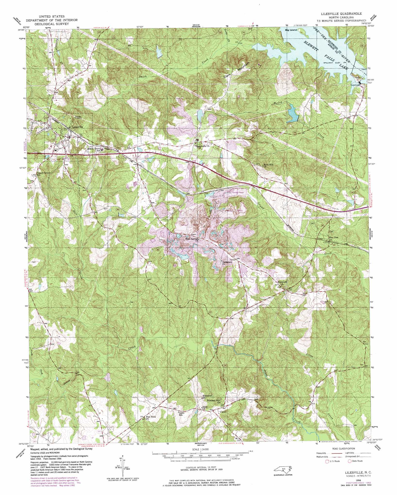
Lilesville Topo Map North Carolina
To zoom in, hover over the map of Lilesville
USGS Topo Quad 34079h8 - 1:24,000 scale
| Topo Map Name: | Lilesville |
| USGS Topo Quad ID: | 34079h8 |
| Print Size: | ca. 21 1/4" wide x 27" high |
| Southeast Coordinates: | 34.875° N latitude / 79.875° W longitude |
| Map Center Coordinates: | 34.9375° N latitude / 79.9375° W longitude |
| U.S. State: | NC |
| Filename: | o34079h8.jpg |
| Download Map JPG Image: | Lilesville topo map 1:24,000 scale |
| Map Type: | Topographic |
| Topo Series: | 7.5´ |
| Map Scale: | 1:24,000 |
| Source of Map Images: | United States Geological Survey (USGS) |
| Alternate Map Versions: |
Lilesville NC 1956, updated 1957 Download PDF Buy paper map Lilesville NC 1956, updated 1957 Download PDF Buy paper map Lilesville NC 1956, updated 1983 Download PDF Buy paper map Lilesville NC 1976, updated 1978 Download PDF Buy paper map Lilesville NC 2010 Download PDF Buy paper map Lilesville NC 2013 Download PDF Buy paper map Lilesville NC 2016 Download PDF Buy paper map |
1:24,000 Topo Quads surrounding Lilesville
Aquadale |
Mount Gilead West |
Mount Gilead East |
Harrisville |
Norman |
Polkton |
Ansonville |
Mangum |
Ellerbe |
Millstone Lake |
Russellville |
Wadesboro |
Lilesville |
Rockingham |
Hamlet |
Mount Croghan |
Morven West |
Morven East |
Diggs |
Ghio |
Ruby |
Chesterfield |
Cheraw |
Wallace |
Bennettsville North |
> Back to 34079e1 at 1:100,000 scale
> Back to 34078a1 at 1:250,000 scale
> Back to U.S. Topo Maps home
Lilesville topo map: Gazetteer
Lilesville: Dams
Blewett Falls Dam elevation 69m 226′Blewitt Falls Lake Dam elevation 53m 173′
Bonsal Company Lake Dam elevation 140m 459′
Hogan Lake Dam elevation 81m 265′
W R Bonsal Tailings Reservoir Dam elevation 143m 469′
Lilesville: Islands
Big Island elevation 55m 180′Lilesville: Populated Places
Cairo elevation 126m 413′Gravelton elevation 142m 465′
Lilesville elevation 152m 498′
Pee Dee elevation 72m 236′
Tindallsville (historical) elevation 151m 495′
Lilesville: Reservoirs
B V Hedrick Sand and Gravel Lake elevation 59m 193′Blewett Falls Lake elevation 49m 160′
Bonsal Company Lake elevation 140m 459′
Hogan Lake elevation 81m 265′
W R Bonsal Tailings Reservoir elevation 143m 469′
Lilesville: Streams
Hale Creek elevation 56m 183′North Fork Smith Creek elevation 56m 183′
Smith Creek elevation 53m 173′
Lilesville: Summits
Clark Mountain elevation 143m 469′Lilesville digital topo map on disk
Buy this Lilesville topo map showing relief, roads, GPS coordinates and other geographical features, as a high-resolution digital map file on DVD:
South Carolina, Western North Carolina & Northeastern Georgia
Buy digital topo maps: South Carolina, Western North Carolina & Northeastern Georgia