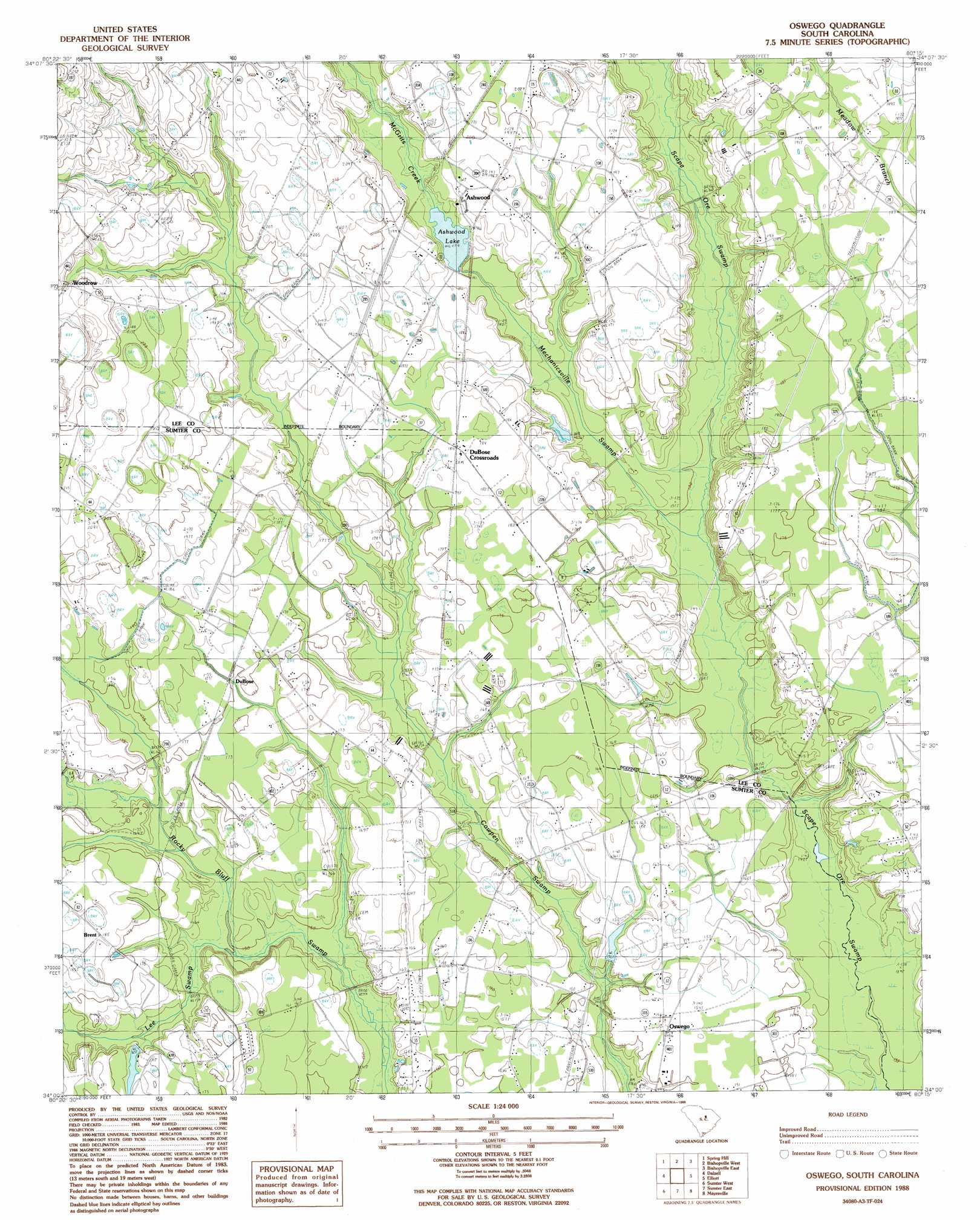
Oswego Topo Map South Carolina
To zoom in, hover over the map of Oswego
USGS Topo Quad 34080a3 - 1:24,000 scale
| Topo Map Name: | Oswego |
| USGS Topo Quad ID: | 34080a3 |
| Print Size: | ca. 21 1/4" wide x 27" high |
| Southeast Coordinates: | 34° N latitude / 80.25° W longitude |
| Map Center Coordinates: | 34.0625° N latitude / 80.3125° W longitude |
| U.S. State: | SC |
| Filename: | o34080a3.jpg |
| Download Map JPG Image: | Oswego topo map 1:24,000 scale |
| Map Type: | Topographic |
| Topo Series: | 7.5´ |
| Map Scale: | 1:24,000 |
| Source of Map Images: | United States Geological Survey (USGS) |
| Alternate Map Versions: |
Oswego SC 1988, updated 1988 Download PDF Buy paper map Oswego SC 2011 Download PDF Buy paper map Oswego SC 2014 Download PDF Buy paper map |
1:24,000 Topo Quads surrounding Oswego
Camden North |
Cassatt |
Lucknow |
Kellytown |
Hartsville South |
Camden South |
Spring Hill |
Bishopville West |
Bishopville East |
Lamar |
Rembert |
Dalzell |
Oswego |
Elliott |
Lynchburg |
Wedgefield |
Sumter West |
Sumter East |
Mayesville |
Turbeville |
Poinsett State Park |
Privateer |
Brogdon |
Tearcoat Branch |
Sardinia |
> Back to 34080a1 at 1:100,000 scale
> Back to 34080a1 at 1:250,000 scale
> Back to U.S. Topo Maps home
Oswego topo map: Gazetteer
Oswego: Dams
Hill Pond Dam D-1980 elevation 64m 209′South Carolina Noname 31012 D-2414 Dam elevation 55m 180′
Oswego: Populated Places
Aman (historical) elevation 58m 190′Ashwood elevation 58m 190′
Brent elevation 56m 183′
DuBose elevation 53m 173′
DuBose Crossroads elevation 55m 180′
McCabe (historical) elevation 60m 196′
Mechanicsville elevation 54m 177′
Oswego elevation 47m 154′
Oswego: Reservoirs
Ashwood Lake elevation 55m 180′Hill Pond elevation 64m 209′
Oswego: Streams
Lee Swamp elevation 46m 150′McGirts Creek elevation 55m 180′
Oswego: Swamps
Mechanicsville Swamp elevation 48m 157′Oswego digital topo map on disk
Buy this Oswego topo map showing relief, roads, GPS coordinates and other geographical features, as a high-resolution digital map file on DVD:
South Carolina, Western North Carolina & Northeastern Georgia
Buy digital topo maps: South Carolina, Western North Carolina & Northeastern Georgia