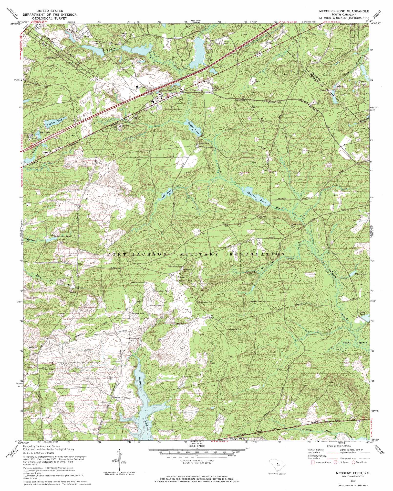
Messers Pond Topo Map South Carolina
To zoom in, hover over the map of Messers Pond
USGS Topo Quad 34080a7 - 1:24,000 scale
| Topo Map Name: | Messers Pond |
| USGS Topo Quad ID: | 34080a7 |
| Print Size: | ca. 21 1/4" wide x 27" high |
| Southeast Coordinates: | 34° N latitude / 80.75° W longitude |
| Map Center Coordinates: | 34.0625° N latitude / 80.8125° W longitude |
| U.S. State: | SC |
| Filename: | o34080a7.jpg |
| Download Map JPG Image: | Messers Pond topo map 1:24,000 scale |
| Map Type: | Topographic |
| Topo Series: | 7.5´ |
| Map Scale: | 1:24,000 |
| Source of Map Images: | United States Geological Survey (USGS) |
| Alternate Map Versions: |
Messers Pond SC 1953, updated 1957 Download PDF Buy paper map Messers Pond SC 1972, updated 1973 Download PDF Buy paper map Messers Pond SC 1972, updated 1973 Download PDF Buy paper map Messers Pond SC 2011 Download PDF Buy paper map Messers Pond SC 2014 Download PDF Buy paper map |
1:24,000 Topo Quads surrounding Messers Pond
Winnsboro Mills |
Ridgeway |
Longtown |
Rabon Crossroads |
Camden North |
Irmo Ne |
Blythewood |
Elgin |
Lugoff |
Camden South |
Columbia North |
Fort Jackson North |
Messers Pond |
Leesburg |
Rembert |
Southwest Columbia |
Fort Jackson South |
Congaree |
Eastover |
Wedgefield |
Gaston |
Saylors Lake |
Gadsden |
Wateree |
Poinsett State Park |
> Back to 34080a1 at 1:100,000 scale
> Back to 34080a1 at 1:250,000 scale
> Back to U.S. Topo Maps home
Messers Pond topo map: Gazetteer
Messers Pond: Crossings
Interchange 80 elevation 122m 400′Interchange 82 elevation 108m 354′
Messers Pond: Dams
Cobbs Pond Dam D-1675 elevation 77m 252′Coopers Lake D-0574 Dam elevation 77m 252′
Dupre Pond Dam D-1674 elevation 79m 259′
Hughes Pond D-0573 Dam elevation 105m 344′
Messers Pond Dam D-1676 elevation 64m 209′
Rotureau Lake Dam D-0572 elevation 93m 305′
Rutledges Pond D-0137 Dam elevation 80m 262′
South Carolina Noname 28045 D-2521 Dam elevation 87m 285′
South Carolina Noname 40089 D-0575 Dam elevation 68m 223′
Upper Davis Pond Dam D-1677 elevation 59m 193′
Messers Pond: Lakes
Old Barstow Pond elevation 86m 282′Messers Pond: Populated Places
Chimney Ridge elevation 117m 383′Lisbon (historical) elevation 137m 449′
Royal Pines Estates elevation 128m 419′
Messers Pond: Reservoirs
Bells Pond elevation 94m 308′Cobbs Pond elevation 77m 252′
Coopers Lake elevation 77m 252′
Davis Pond elevation 58m 190′
Dupre Pond elevation 79m 259′
F Coopers Pond elevation 68m 223′
Hughes Pond elevation 103m 337′
Messers Pond elevation 64m 209′
Odom Pond elevation 62m 203′
Powell Pond elevation 87m 285′
Rotureau Lake elevation 93m 305′
Ruthledges Pond elevation 80m 262′
Wise Pond elevation 79m 259′
Messers Pond: Streams
Buffalo Creek elevation 59m 193′Messers Pond: Swamps
Noahs Marsh elevation 54m 177′Wise Marsh elevation 68m 223′
Messers Pond digital topo map on disk
Buy this Messers Pond topo map showing relief, roads, GPS coordinates and other geographical features, as a high-resolution digital map file on DVD:
South Carolina, Western North Carolina & Northeastern Georgia
Buy digital topo maps: South Carolina, Western North Carolina & Northeastern Georgia